|
Latest Seasonal Assessment -
Since the previous outlook issued during mid-March, drought coverage and intensity remained nearly steady across the West with more than two-thirds of California
designated with extreme to exceptional drought. Drought intensified during the past month across the central and southern Great Plains, while the Midwest experienced
drought reduction. Most of the eastern U.S. remains drought-free.
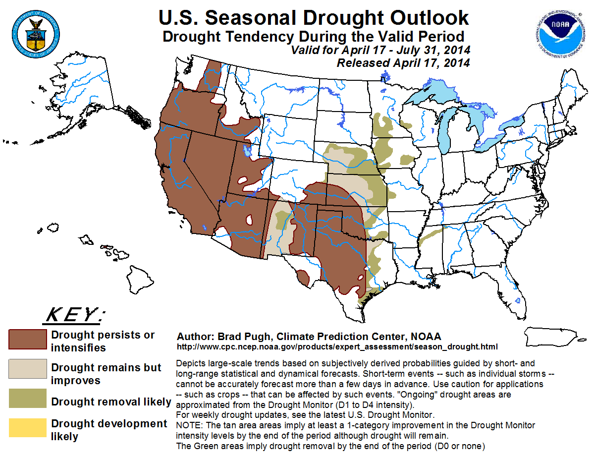
The drought outlook valid from April 17 to July 31, 2014 is based primarily on initial conditions, short-, medium-, and long-range forecasts, and climatology. Persistence
or intensification is likely for the ongoing drought areas of the Pacific Northwest, California, and Great Basin as those areas enter an increasingly dry time of year.
Also, the CPC seasonal outlook calls for enhanced odds for above-normal temperatures across the West. Persistence is forecast for much of the Southwest, although
improvement/removal is forecast for western New Mexico as the CPC May-June-July outlook calls for increased chances of above-median precipitation. Improvement is not
expected to occur until July with the onset of monsoon rainfall. Improvement and removal of drought across the central/southern Great Plains and Midwest is based on
expected rainfall during the remainder of April and a relatively wet time of year as the convective season peaks. However, persistence is most likely for the protracted
drought areas of the high Plains.
Although drought is not expected to develop through the end of July along and east of the Mississippi River, summer heat coupled with insufficient rainfall over a
multi-week period can result in rapid drought development during the summer.
|
|
Tools used in the U.S. Seasonal Drought Outlook (SDO) included the official Climate Prediction Center (CPC) temperature and precipitation outlooks for
May 2014, the long lead forecast for May-June-July 2014, various short- and medium-range forecasts and models such as the 5-day and 7-day precipitation totals from
the Weather Prediction Center, 6-10 day and 8-14 day CPC forecasts, the NAEFS precipitation outlooks, the soil moisture tools
based on the Constructed Analog on Soil (CAS) moisture, dynamical models (CFSv2, NMME, and IMME), the 384-hour total precipitation forecasts from several runs of
the GFS, the four-month Palmer drought termination and amelioration probabilities, climatology, and initial conditions. The chances of El Niño increase during the
2014 summer, with the CPC/IRI consensus forecast indicating a 52% chance of El Niño developing by August.
Insufficient precipitation occurred during the past three wet seasons across California. According to the National Climatic Data Center’s State of the Climate report, the
30-month period from October 2011-March 2014 is the driest 30-month period, statewide, in the 1895-2014 record. Therefore, a large coverage of extreme to exceptional
drought continues to plague California with more than two-thirds of the state designated in these two drought categories, as of the U.S. Drought Monitor on April 8.
Lake Shasta, California’s largest reservoir, increased storage from 53% to 60% of the long-term average during March, but snow water equivalent values remain very low
across the Sierras at this time of the year. Due to the extremely dry initial conditions and a drier climatology during the outlook period, persistence or
intensification of drought is forecast for California.
Forecast confidence for California is high.
Following a slow start to the wet season across the Pacific Northwest, March became much wetter due to an increase in onshore flow. Seattle, Washington recorded its
wettest March in a 67-year record at 9.44 inches of precipitation, while Portland, Oregon tied 1957 for the second wettest March dating back to 1938. The wetter
pattern resulted in a significant increase in snowpack across the northern Cascades and drought reduction across Washington. Drought coverage and intensity remained
nearly steady across the Great Basin. Although the upper-level pattern favors near to above-median precipitation during the remainder of April, no widespread drought
improvement is expected for the Pacific Northwest and Great Basin. Based on a drier climatology, persistence is most likely for these areas.
Forecast confidence for the Pacific Northwest and Great Basin is high.
Long-term drought continues across the Southwest with the most intense drought centered over eastern New Mexico. October 2010-March 2014 ranked as the 3rd driest
42-month period for New Mexico in the 1895-2014 record. During the past 90-days, precipitation is within 1 inch of average across most of New Mexico, while larger
precipitation deficits exist at this time scale across most of Arizona, southwest Colorado, and southern Utah. The CPC May-June-July precipitation outlook calls for
increased chances of above-median precipitation across the Southwest. Drought improvement or removal (where D1 is depicted in the U.S. Drought Monitor) is forecast
for western New Mexico where drought levels are moderate to severe and 90-day precipitation deficits are smaller than the remainder of the Southwest. It should be
noted that monsoon rainfall typically does not increase until July. For example, May and June are the two driest months of the year in Tucson, Arizona with the
normal July rainfall increasing to more than 2 inches. Any improvement of drought is likely not to occur until mid to late July. Enhanced odds for above-normal
temperatures across the Southwest in the CPC May and May-June-July temperature outlooks reduce forecast confidence for any improvement by the end of July.
Forecast confidence for the Southwest is low.
Due to a relatively dry February and March, drought intensified across Kansas, Oklahoma, and much of Texas. Multiple lakes in the Dallas-Fort Worth, Texas area are
around 50 percent of full pool. The CPC monthly and seasonal outlooks call for equal chances of above, near, or below-median precipitation across the central and
southern Great Plains during MJJ. However, the upper-level pattern featuring a trough upstream during the remainder of April and possibly into the beginning of May
is favorable for at least seasonal rainfall amounts. Rainfall associated with the convective season peaks during the next two months. Climatology and near to
above-median precipitation, as forecast in the CPC 6-10/8-14 Day outlook on April 16, favor improvement or removal of drought across parts of the central/southern
Great Plains and southeast Texas. However, persistence is more likely for the entrenched drought areas of the high Plains. The CPC monthly and seasonal temperature
outlooks call for enhanced odds for above-normal temperatures which could intensify drought conditions if rainfall remains at or below-normal.
Forecast confidence for the central/southern Great Plains and southeast Texas is moderate.
During early to mid-April, moderate to heavy precipitation reduced or alleviated drought across the Midwest. Near to above-median precipitation is favored during
the remainder of April across this region. 35 to 45 percent of the annual precipitation occurs during May through July across the Midwest. Given the relatively wet
climatology and favorable pattern for precipitation during the next two weeks, improvement or removal of drought is expected for the Midwest.
Forecast confidence for the Midwest is high.
On the March 25 U.S. Drought Monitor, a small area of moderate drought was depicted across northern Mississippi. During the past week, 0.5 to 2.0 inches of rain fell across this area. Since no precipitation tool offers a dry signal, removal is likely for this small drought area.
Forecast confidence for northern Mississippi is high.
Drought continued to ease across the Hawaiian Islands during the past couple of months. The only remaining drought area (as depicted on the April 8 U.S. Drought
Monitor) exists on Molokai. This drought area is associated with low water levels on the Kualapuu reservoir. Since the Hawaiian Islands are entering their dry season,
persistence is forecast for the remaining drought area in Hawaii.
Forecast confidence for Hawaii is moderate.
|


