|
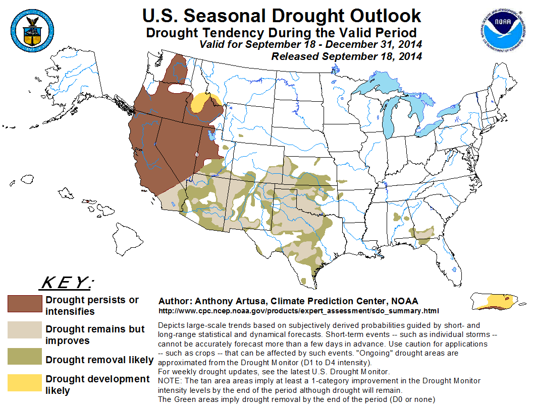
During the past 30-days, much of the Four Corners region experienced a continuation of robust monsoon conditions along with beneficial precipitation, while other areas
received subnormal precipitation. The Pacific Northwest, most of California, and western and central Nevada remained fairly dry. Other areas of the country which received
surplus precipitation included northern Kansas, the southern High Plains, far southern Texas, and much of Georgia and adjacent parts of the Florida Panhandle. Eastern and
southern Puerto Rico, and Hawaii continue to dry out. For the upcoming October-November-December (OND) 2014 season, a wet pattern is expected to continue across the
Southwest, the southern third of California, the southern Great Plains region, and the eastern Gulf Coast states. This is based on such factors as the CPC 1-month and
3-month precipitation outlooks, various dynamical and statistical models, and the expectation of a weak El Niño which is often characterized by an active subtropical jet
stream across the southern tier of the contiguous U.S. However, the Pacific Northwest, and northern and central sections of California and Nevada, and much of western Utah
are predicted to have elevated odds of below-median precipitation during the OND period, based in part on the factors noted above. For California, historical composites of
weak El Niño's favor enhanced odds of above-median precipitation across the southern third of the state, with much less support for surplus precipitation farther north.
Therefore, improvement or removal of drought is anticipated from southern sections of California and Nevada eastward across the Southwest into the central and southern
Great Plains, as well as the eastern Gulf Coast states. Persistence/intensification of drought is favored over the Pacific Northwest, northern and central California, and
most of the central Inter-mountain region. Persistence and/or intensification of drought are also favored over Hawaii and Puerto Rico during autumn.
|
|
Tools used in the U.S. Seasonal Drought Outlook (SDO) included the official Climate Prediction Center (CPC) temperature and precipitation outlooks for
October 2014 and October-December 2014,
various short- and medium-range forecasts and models such as the forecast 5-day and 7-day precipitation totals from the Weather
Prediction Center (WPC), the 6-10 day and 8-14 day CPC forecasts, the NAEFS precipitation outlooks, the soil moisture tools
based on the Constructed Analog on Soil Moisture (CAS), dynamical models (CFSv2, NMME, IRI, and IMME), the 384-hour total precipitation forecasts from several runs of
the GFS, the four-month Palmer drought termination and amelioration probabilities, climatology, and initial conditions. An El Niño Watch is currently in effect, with
the September 4 ENSO Diagnostic Discussion indicating a 60-65% chance of El Niño during the fall and early winter.
During the past two weeks, rainfall surpluses (1-3 inches, locally more) have accumulated over much of Georgia, northern Florida, and to a lesser extent Alabama.
Typically, only 15-20 percent of the region's annual precipitation is received during the October-December season. There are elevated odds for near to above-median
precipitation during the Week 2 period. CPC's precipitation outlook for October-November-December (OND) calls for weak tilts in the probabilities towards above-median
precipitation. A one-category improvement is anticipated across this area (D1 areas on the U.S. Drought Monitor are therefore expected to become D0 which indicates
drought removal).
Forecast confidence for the Southeast is moderate.
Within the past two weeks, precipitation deficits of 1-2 inches were noted in central and eastern portions of Kansas, and precipitation surpluses of 1-4 inches
(locally heavier) were observed in the Texas Panhandle, extreme southern Texas, and scattered portions of Oklahoma. Kansas and the high plains of both Oklahoma and
Texas normally receive from 10-20 percent of their annual precipitation during OND, while the lower plains of both Oklahoma and Texas typically receive 20-30 percent
of their annual precipitation during the same period. Between 2.5-3.5 inches of rain is forecast during the first few days of this Outlook across central Oklahoma,
and central and southeast Texas, while moderate precipitation (0.5-2.0 inches) is anticipated over most of the remainder of this region. The CPC precipitation
outlook for OND 2014 calls for elevated chances of above-median precipitation for most of the region, with EC deemed the best bet for Kansas. As a result, a
1-category improvement is predicted across the southern Great Plains. The outlook for this region is also consistent with the expectation of a somewhat enhanced El
Niño-related subtropical jet stream across the southern tier of the U.S., especially later in the season.
Forecast confidence for the central and southern Great Plains is moderate.
In the Southwest, both the summer monsoon and the eastern Pacific hurricane season continue to be quite active, where rainfall surpluses have generally ranged
from 1-4 inches in southern and central Arizona, and 1-2 inches in southern portions of both New Mexico (1-5 inches in extreme southeast New Mexico) and Nevada
during the past two weeks. Percent of Normal Precipitation (PNP) has ranged from 150-400 percent of normal (locally greater) during the past 30 days in these same
areas. By October, the monsoon typically winds down rapidly, though the eastern Pacific hurricane season can still be very active. Near-median rainfall is favored
during the Week 2 period, and above-median precipitation is predicted for both the month of October and the OND season. Therefore, areas of drought improvement and
removal are anticipated.
Forecast confidence for the Southwest is moderate to high.
During the past 30-days, portions of far southern California, eastern Nevada, and western Utah have received significant amounts of precipitation (PNPs 150-400
percent of normal). However, most remaining areas of California and Nevada have PNP values ranging from 5-25 percent. Northern and central California, and western
Nevada, typically receive 30-40 percent of their annual precipitation during the OND season, while remaining portions of those two states and Utah receive between
20-30 percent. For October, there are enhanced odds of above-median precipitation in Utah, and southeast portions of California and Nevada, with Equal Chances (EC) of
below, near, and above-median precipitation amounts expected elsewhere. For the OND season, CPC's precipitation outlook favors below-median precipitation over
northern California and northwestern Nevada, above-median precipitation over far southern California, and EC anticipated elsewhere. The U.S. Seasonal Drought Outlook
favors drought persistence/intensification across all but far southern sections of both California and Nevada, and much of western Utah, with improvement or removal
of drought conditions favored south of this persistence/intensification area.
Forecast confidence for the central Intermountain Region and California is low.
In the Pacific Northwest, the past 30-days have featured low precipitation amounts, as is typical during the dry summer season. PNPs across most of the region
generally range from 5 to 50 percent. The Pacific Northwest typically receives 30-45 percent of its annual precipitation during OND, which coincides with the
climatological onset of the region's wet season. Uncertainty is too high to predict areas of drought development in Washington and Oregon, though a small area of
possible development is retained in central Idaho. The October 2014 precipitation outlook favors below-median precipitation over western sections of both Washington
and Oregon, and EC elsewhere. Below-median precipitation is favored for most of the Pacific Northwest during the OND season.
Forecast confidence for the Pacific Northwest is moderate.
A small area of moderate drought - D1(L) - remained on Hawaii's Molokai Island, based upon a low reservoir. Although there is a correlation between El Niño
conditions and below-normal rainfall across Hawaii, this relationship is more pronounced during the winter months, rather than in autumn. Based on climatology,
current conditions, and outlooks, drought persistence is anticipated.
Forecast confidence for Hawaii is moderate.
According to the National Weather Service's Advanced Hydrologic Prediction Service (AHPS), during the past 14-days Puerto Rico experienced surplus rainfall (PNP
values between 150-300) over northwest and northern parts of the island, and deficits (PNP values between 10-50) over eastern and southern parts of the island. The
tropical wave that was yet to become Tropical Storm Cristobal brought anywhere from 4-13 inches of rain to Puerto Rico over the three day period, August 22-24. This
long duration of heavy rain resulted in widespread flooding across the Island, despite the fact that soils were still rather dry after a summer of below-normal
precipitation. The 2014 Atlantic hurricane season as a whole, though, has featured well-below normal activity, and drought persistence and development is still
anticipated to dominate southern and eastern Puerto Rico during the OND season.
Forecast confidence for Puerto Rico is moderate.
|


