|
Latest Seasonal Assessment -
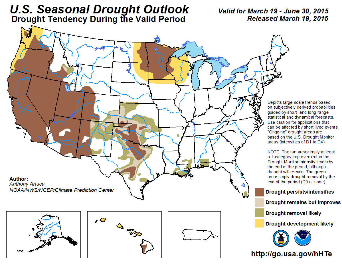
With the gradual winding down of the wet season in the West, prospects for drought relief during the spring are low. Persistence and/or intensification of drought
conditions is anticipated across the West, with drought development favored in western sections of both Washington and Oregon. In Arizona, Utah, and western portions of
both Colorado and New Mexico, drought persistence/intensification is deemed most likely, as spring tends to be a relatively dry time of year, in advance of the summer
Monsoon. For much of the southern Rockies and south-central Plains, drought improvement and/or removal is predicted, based on the latest precipitation outlooks from CPC
for April and April-June, and on spring climatology. Persistence and/or intensification of drought is forecast for the core drought areas of the south-central Plains,
however, which are currently experiencing extreme or exceptional drought conditions. These core drought areas will need significant amounts of rain to offset the long
duration and severity of present drought conditions. In the Upper Midwest, the areal coverage of moderate drought has expanded in the past week, and a sizable region of
drought development is anticipated around it. With a relatively dry antecedent autumn and winter, soils in the region have become very dry, and a lack of snowpack has
likely contributed to the record warm temperatures that occurred during the last 1-2 weeks. The CPC monthly and seasonal precipitation outlooks favor the continuation of
below-median precipitation across the Upper Midwest, which would lead to further expansion of drought. In contrast, the CPC precipitation outlooks anticipate enhanced
odds of above-median precipitation across the lower Mississippi Valley and central Gulf Coast region, prompting a forecast for removal of drought in those areas. For the
Florida Everglades, the climatological onset of the rainy season in late May warrants the removal of drought conditions. In Hawaii, though above-median rainfall is
expected during April and AMJ by CPC, it will be difficult to get a one-category improvement. Therefore, areas of drought persistence and/or intensification and drought
development are indicated.
|
|
Tools used in the U.S. Seasonal Drought Outlook (SDO) included the official Climate Prediction Center (CPC) temperature and precipitation outlooks
for April 2015 and April-June 2015, various short- and medium-range forecasts and models such as the 5-day and 7-day precipitation totals forecast (QPFs) from the
Weather Prediction Center (WPC), the 6-10 day and 8-14 day CPC extended-range forecasts (ERFs), the
NAEFS precipitation outlooks, the soil moisture tools based on
the Constructed Analog on Soil Moisture (CAS), dynamical models (CFSv2, NMME, IRI, IMME, and ECMWF), the 384-hour total precipitation forecasts from several runs of the
GFS, the four-month Palmer drought termination and amelioration probabilities, Apr and Apr-Jun climatology, and initial conditions. An El Niño (ENSO) Advisory is now in
effect, with the March 5 ENSO Diagnostic Discussion indicating a 50-60 percent chance of El Niño conditions continuing through Northern Hemisphere summer 2015.
During the past 30 days, much of California and Nevada have received less than a half-inch of precipitation (liquid equivalent). Very localized amounts between 0.5-3.0
inches fell in parts of the Sierras, extreme northwest and extreme southeast California, and along the southern coast, especially in mountainous areas, and southern
Nevada. In both Washington and Oregon, the coastal ranges and Cascades reported anywhere from 4-10 inches of precipitation during this period, with spotty heavier amounts.
Generally under one inch of precipitation fell east of the Cascades in both states. Percent of Normal Precipitation (PNP) has ranged between the 25th and 75th percentiles
in the past 30-days across Washington and Oregon, and southern sections of Nevada and California. PNP values below the 25th percentile were noted in approximately the
northern halves of California and Nevada. Water-Year-To-Date (WYTD) precipitation (since October 1, 2014) ranges between 50-100 percent in Washington and Oregon, and
between 25-75 percent in California and Nevada. In general, the winter season has been characterized by persistent upper-level ridging over the western contiguous U.S.,
and warmer than normal temperatures. This has resulted in well below-normal mountain snowpack (less than 25 percent of median in Oregon, and less than 50 percent of median
in Washington, Nevada and the California Sierras), as much of the precipitation fell as rain. SNOTEL Snow Water Content (SWC) is currently less than 50 percent of normal
in most of Washington, Oregon, Nevada, and the Sierras. Reservoir levels continue to run well below-normal in California; from about 29-37 percent of capacity in the
southern third of the state, 17-68 percent in the central third of the state, and 48-59 percent of capacity in the northern third of California (Department of Water
Resources, California Data Exchange Center). The Palmer Drought Termination and Amelioration tool indicates approximately 18-21 inches of rain would be needed to end the
current drought in central and southern coastal areas of California and the Central Valley, 15-18 inches for the northern coast of California, and about 12-15 inches for
the interior of northern California. Unfortunately, with such low snowpack and SWC's by the start of spring, the amount of melt water available for gradual release during
the spring and summer months will be seriously inadequate.
The CPC April 2015 and April-June 2015 temperature outlooks call for elevated odds of above-normal temperatures across the West. CPC's April and April-June precipitation
outlooks favor below-median in western Washington and western Oregon, above-median in eastern Nevada, and Equal Chances (EC) elsewhere. With the climatological rainy
season winding down in March and April, and the reduced precipitation received across the West during the past month, prospects for any significant drought relief are low.
Therefore, persistence and/or intensification of drought is anticipated in the West. Drought development is favored in parts of the Pacific Northwest.
Forecast confidence for the West is high for persistence areas and moderate for additional drought expansion across the Northwest.
In the Southwest, WYTD precipitation ranges between 25-50 percent of normal in Utah, western Colorado, much of Arizona, and far western and east-central New Mexico. WYTD
precipitation ranges between 110-200 percent of normal in west-central and far eastern New Mexico, and eastern Colorado. SWC values are less than 50 percent in the
Mogollon Rim area of south-central Arizona, and southwestern New Mexico, and 50-90 percent of normal for most of the remainder of New Mexico, Utah, and western Colorado.
Mountain snowpack has been less than 50 percent of median in northern and central Arizona, and 25-70 percent in western New Mexico. Snowpack has been much more variable in
spatial coverage across central Utah (25-130 percent) and west-central Colorado and north-central New Mexico (50-130 percent of median).
Precipitation normally winds down in April across the Southwest, and pre-monsoon dryness dominates the months of May and June. CPC's April and AMJ temperature outlooks
indicate elevated odds for above-normal temperatures in western portions of the Four Corners region, and favor below-normal temperatures in eastern portions of the Four
Corners region, separated by a band of EC. The CPC April and AMJ outlooks for precipitation show enhanced odds of above-median precipitation, centered over New Mexico.
Most, if not all, of the anticipated precipitation, is expected to fall in April. A major challenge for the Seasonal Drought Outlook across the Southwest is to determine
how much drought relief is likely, given a forecast favoring wetter-than-median conditions. With such a dry climatology at this time of year, even a few millimeters of
rain could result in above-median precipitation in many areas. It is reasoned that even though the region may experience short-term improvements due to April rainfall, it
is unlikely to result in any long-term improvements such as significantly boosted reservoir levels. A one-category improvement appears to be most likely in the outlooked
area of highest probability for above-median precipitation, namely New Mexico and nearby parts of southwestern Colorado and eastern Arizona. Elsewhere,
persistence/intensification of drought conditions is expected.
Forecast confidence for the Southwest is low to moderate.
In the north-central Rockies (southern Idaho, southwestern Wyoming, and northwestern Colorado), mountain snowpack generally varies between 25-90 percent of median. SNOTEL
SWC varies between 50-110 percent of median. The NMME, IMME, and CFS favor near- to above-median precipitation for the month of April, with the greater tendency for
abnormal wetness farther east, which is more consistent with climatology. These same tools predict enhanced odds of above-median precipitation for the AMJ season. The CPC
30-day and 90-day precipitation outlooks favor borderline conditions between EC and a very modest tilt toward above-median precipitation. Some drought relief is possible
in east-central Idaho, while Persistence is thought to be the best forecast for remaining areas.
Forecast confidence for the north-central Rockies is low.
During the past 30-days, 4-6 inches of precipitation (locally heavier) fell in eastern portions of both Texas and Oklahoma, while most other areas of the southern Plains
received less than 2 inches. The April and April-June precipitation forecasts from the NMME, IMME, and CFS generally favor above-median precipitation in this region.
The 30-day and 90-day precipitation outlooks from CPC favor above-median precipitation across the High Plains, and EC for the lower Plains. This is generally consistent
with a wetter spring climatology in the southern Plains. Approximately 35-40 percent of the annual precipitation for the southern High Plains is received during the AMJ
season. Based on these considerations, a one-category (or more) improvement is expected over much of the region, except for the core drought region of extreme drought (D3)
and exceptional drought (D4), where more substantial rainfall is needed.
Forecast confidence for the south-central Plains is low to moderate.
Temperature observations for the Dec-Feb 2014-15 winter season reveal a prominent gradient across the Upper Midwest. Central Minnesota and central Iowa represent the
approximate dividing line, separating above-normal temperatures to the west and below-normal temperatures to the east. Soils in the eastern areas have thawed significantly
from the long duration of arctic air masses this winter season, and are quite dry. It is thought that the dryness of the soils throughout the antecedent autumn and winter
contributed to the record warm temperatures in parts of the Upper Midwest during the past 1-2 weeks. In addition, abnormally low snow cover has receded, with the last
remaining areas of snow in the Arrowhead region of northeastern Minnesota and the Upper Peninsula of Michigan. The CPC 30-day and 90-day precipitation outlooks favor
below-median precipitation across the Upper Midwest. Near to below-median precipitation is predicted by the NMME, IMME, and CFS dynamical tools. In contrast, the spring is
typically a wetter time of year for this region. Given the dynamical input, and the persistence of dry soils, areas of persistence/intensification and drought development
are indicated on the map.
Forecast confidence for the upper Midwest is moderate.
During the last 60-days, much of Arkansas has reported surplus precipitation (1-4 inches), while the central Gulf Coast region has reported deficit
precipitation (generally 1-3 inches, except 2-6 inches (locally greater) in extreme southeastern Alabama. The NMME, IMME, and CFS predict above-median precipitation for
both April and April-June. The official CPC April and AMJ precipitation outlooks also generally favor above-median precipitation for most areas. Therefore, either drought
improvement or removal is predicted. For the Florida Everglades, the wet season usually begins toward very late May, and so drought removal is anticipated there.
Forecast confidence for the lower Mississippi Valley/central Gulf Coast region is moderate, and moderate to high for the Florida Everglades.
Despite CPC's relatively wet forecast for parts of Hawaii in both April and AMJ, it will be difficult to achieve a one-category improvement. Therefore, Persistence and/or
Intensification of drought is considered most likely.
Forecast confidence for Hawaii is low to moderate.
|


