|
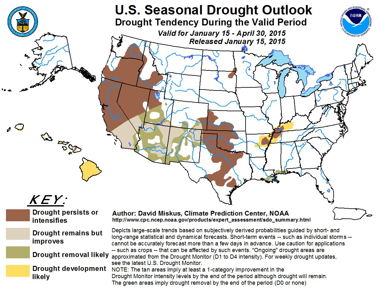
Latest Seasonal Assessment -
Drought (D1 or drier) remained nearly non-existent in the eastern half of the Nation, with only a few small areas along the central Gulf Coast and in the western Tennessee
Valley. Recent widespread and heavy precipitation diminished the coverage and intensity of dryness and drought in the East and South. In contrast, long-term drought
remained entrenched in California, the Intermountain West, most of the Great Basin and Southwest, and the southern third of the Plains, although there were some
improvements made since the last SDO (released December 18, 2014). In north-central California, a 1-category improvement (from D4 to D3) occurred due to copious
precipitation from late November until mid-December, causing localized flooding that also raised major reservoir capacities to levels where drought improvement was
necessary. Minor improvements were also made in parts of the Northwest and Southwest. Since December 20, however, precipitation has been nearly non-existent across much of
California and Nevada, halting the favorable moisture conditions that had raised hopes for additional winter drought improvement in California. In addition, the mild
winter weather has allowed most of the precipitation to fall as rain instead of snow in higher elevations, reducing the snow water content (SWC) of Cascade and Sierra
Nevada sites to less than 40 percent of normal as of January 13. In the Plains, spotty precipitation since mid-December produced a mixed bag of some improvement and
deterioration. Finally, small areas of drought persisted on Maui and Molokai in Hawaii, although coverage of abnormal dryness increased. The January 12 ENSO Diagnostic
Discussion indicated a 50-60 percent chance of El Niño conditions during the next few months, with ENSO-neutral favored thereafter.
The drought outlook valid from January 15 through April 30 is based primarily on initial conditions, the February and February-April precipitation outlooks, El Niño
precipitation composites (a weak episode is possible this winter), and climatology. In California, the wet climatology for February and March (especially in the south) and
a tilt of the odds toward above-normal precipitation in the monthly and seasonal outlooks across the southern half of the state should bring improvement there, but it must
be emphasized that improvement is not elimination, and that most of the state will still be in drought to some degree by the end of April. Farther north, snowfall in the
Sierras and Cascades will also be critical to ensure adequate spring and summer snowmelt and runoff, but with such low SWCs as of January 13, equal chances in northern
California and southern Oregon and slight odds for sub-median precipitation in Washington in both the monthly and seasonal outlooks, spring runoff conditions are not
looking promising, hence persistence in northern California and the Northwest. Elsewhere, monthly and seasonal precipitation odds favor some drought improvement across the
Four Corners region into the southern High Plains. Along the central Gulf Coast, short-term forecasts point toward a continuation of the recent wet spell (although equal
chances in the monthly or seasonal outlooks), thus improvement was rendered here. In contrast, drought is expected to persist in the southern third of the Great Plains
and in the eastern Dakotas. Drought expansion is expected in the Tennessee Valley (dryness hinted by many dynamical models), and on the leeward sides of the Hawaiian
Islands and much of the Big Island (monthly and seasonal Hawaiian outlooks favor submedian rainfall during their wet time of the year).
|
|
Tools used in the U.S. Seasonal Drought Outlook (SDO) included the official Climate Prediction Center (CPC) temperature and precipitation outlooks for
February 2015 and February-April 2015, various short- and medium-range forecasts and models such as the 5-day and 7-day precipitation totals forecast (QPFs) from the Weather
Prediction Center (WPC), the 6-10 day and 8-14 day CPC extended-range forecasts (ERFs), the NAEFS precipitation outlooks, the soil moisture tools based on
the Constructed Analog on Soil Moisture (CAS), dynamical models (CFSv2, NMME, IRI, IMME, and European),
the 384-hour total precipitation forecasts from several runs of the GFS, the four-month Palmer drought termination and amelioration probabilities, Feb and Feb-Apr
climatology, and initial conditions. An El Niño (ENSO) Watch is still in effect, with the January 12 ENSO Diagnostic Discussion indicating a 50-60 percent chance of El
Niño conditions during the next few months, with ENSO-neutral favored thereafter.
As of January 14, although the Water Year-to-Date (WYTD) precipitation has been at or above normal for the Northwest and northern California, the snow pack is very low in
the Cascade and Sierra Nevada Mountains. This is because mild air has accompanied the storm systems, generating precipitation that falls as rain even in the higher
elevations. This has produced very low snow water content (SWC) in the Cascades (0-50 percent of normal) and Sierra Nevada (34 to 52 percent of normal). A good snowpack is
essential to spring and summer snowmelt runoff that continually feeds the rivers and reservoirs. The next 7-days should bring heavy precipitation (good news) and mild
weather (bad news)from northern California northward. The 6-10 and 8-14 day ERFs then favor sub median precipitation and above median temperatures, as do the 1- and
3-month outlooks (except that dry odds are limited to Washington, and equal-chances of precipitation southward into northern California). Although there may be some
short-term minimal improvement made to the edges of the drought in the Northwest due to the expected QPF heavy precipitation, the recent dry spell in California, the
unfavorable or uncertain longer-term outlooks, and current low SWCs are not conducive for improvement in this region, hence status-quo (persistence).
Forecast confidence for northern California and the Northwest is moderate.
Thanks to a robust summer monsoon season, drought is not as widespread or severe across the Southwest as it is in California. Nevertheless, pockets of severe (or worse)
drought still existed in parts of Arizona, Utah, New Mexico, and southern Colorado. Although the short- and medium-term forecasts call for little or no precipitation
(except in eastern sections), the monthly and seasonal outlooks both have favorable chances of above median precipitation from southern California eastward into the
southern half of the High Plains, mainly from dynamical models that incorporate a weak El Niño signal the next few months. With February and March climatologically wet in
southern California, surplus precipitation would definitely help with the drought there. This would also boost mountain SWCs across Arizona and New Mexico and southern
sections of Utah and Colorado that stand at 50-75 percent of normal as of Jan. 13. However, there is a chance that the possible El Niño could fizzle instead of developing
during the next few months, hence the lowering of confidence of this forecast.
Forecast confidence is low to moderate in southern California and the Four Corners Region.
Although a large area of abnormal dryness (D0) envelops the northern Great Plains and upper Midwest, only a small area of the eastern Dakotas was in drought (D1). Much of
the dryness came from a very dry fall (after a fairly wet summer), but frigid winter temperatures have frozen the ground, locking conditions in place until the spring
thaw. Not much change is expected until the ground thaws, possibly in March or early April, but another factor to consider is the anemic snow cover across the region
(trace to 4 inches). If additional snow fails to accumulate, or the existing snow sublimes or melts away, this area is primed for degradation when the ground completely
thaws. Only the 6-10 day forecast has favorable odds of above-median precipitation; the 7-day QPF is dry while the 8-14 day ERF is near normal, and the monthly and
seasonal outlooks have equal chances. Because the wet season climatologically starts during April in the north-central Plains, the uncertainty of April's forecast
slightly lowers the confidence.
Forecast confidence for the northern Great Plains (eastern Dakotas) is moderate to high.
In the southern Plains, surplus precipitation during the past 30 days provided some drought relief in eastern, southeastern, and southwestern Texas, and eastern Oklahoma,
but drier conditions across central Texas, the Panhandle, and western Oklahoma worsened the drought. The 7-day QPF is mostly dry for this region, but the 6-10 and 8-14 day
ERFs probabilities are tilted toward above median precipitation. The February outlook calls for enhanced chances of subnormal temperatures and above median precipitation.
The FMA outlook remains confident for subnormal temperatures but only predicts equal chances of precipitation, with the above median precipitation odds shifted farther
west into the Southwest. A second limiting factor for seasonal improvement in Texas was that February and March are climatologically dry, with April only a bit wetter.
Lastly, many of the drought impacts are long-term (hydrologic) with many reservoirs near record low levels. It will take a sustained period of above normal precipitation
to significantly raise the reservoir capacities. Therefore, drought persistence is forecast for the southern Great Plains.
Forecast confidence for the southern Plains is moderate.
A small area of drought in the lower Mississippi and western Tennessee Valleys (northeastern Arkansas into western Kentucky) has recently expanded as 90-day precipitation
deficits of 6-8 inches have accumulated. Heavier precipitation from recent storm systems have bypassed this area, dropping surplus precipitation just to the north and
south. Although short-term forecasts are dry, the ERFs favor somewhat above-median chances of precipitation. Although there is no tilt either way in both the monthly and
seasonal precipitation outlooks, the dynamical models have weak El Niño signals for sub median precipitation at the FMA time scale here and northeastward into the Ohio
Valley. Since the Ohio Valley has been wetter (and above-normal) than the Tennessee Valley, only the latter region is included for development.
Forecast confidence in the Tennessee Valley is low to moderate.
Improvement is forecast along the central Gulf Coast as recent (past 30 days) heavy rains have eased drought conditions across much of the Southeast from deficits that had
accumulated during the fall months. The short- and medium-term forecasts are favorable in continuing the recent wet spell in the Southeast - although the monthly and
seasonal precipitation outlooks have equal chances (no odds either way). With the months of February and March somewhat climatologically wet in the Deep South, the
dynamical models having weak (but diminishing) signals for wetness (related to expected El Niño conditions), and that now is a good time for soil moisture recharge
(low temperatures and evaporation, minimal vegetative growth), the overall balance went toward improvement instead of persistence.
Forecast confidence for the central Gulf Coast is moderate.
There is a decent tilt toward submedian precipitation in both the monthly and seasonal outlooks across Hawaii during the typically wettest time of the year (winter). Since
precipitation during the cool season are the most critical in determining the evolution of any drought across the islands, the small D1 areas are expected to persist, and
the current abnormally dry (D0) portions are forecast to deteriorate. By the end of April, drought should cover the leeward sides of the islands and most of the Big
Island. Although the 1- and 3-month models are quite confident in the odds for subnormal rainfall, there is some inherent uncertainty in forecasting development of drought
out to three months where recent dryness (D0) was recently added, therefore the confidence is slightly reduced from high to moderate.
Forecast confidence for Hawaii is moderate.
|


