|
Latest Seasonal Assessment -
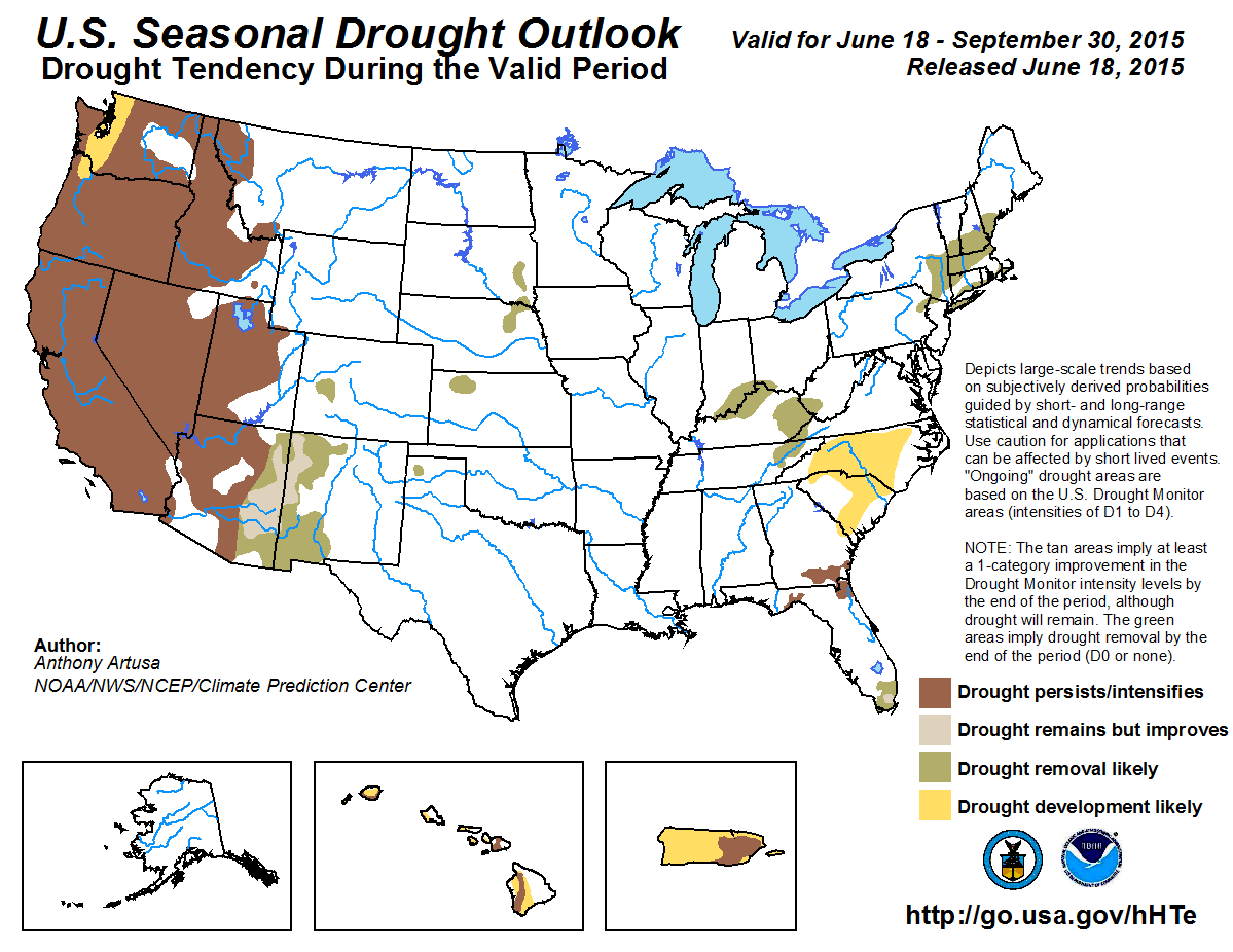
During the past 14-days, above-median rainfall amounts were reported across portions of the Four Corners region, the central and southern Rockies, much of the Great
Plains, the middle Mississippi and northern Ohio Valleys, the Great Lakes region, and the interior Northeast. For the upcoming three-month period (July-August-September,
or JAS 2015), most climate models favor above-median rainfall from eastern Arizona to west Texas, in connection with the seasonal Summer Monsoon. A one-category
improvement is favored in this region. With El Niño now established across the tropical Pacific, there are enhanced chances of an active eastern Pacific hurricane season.
Moisture from tropical systems may reach the Southwest CONUS, especially towards the tail end of this seasonal outlook. For most of the remainder of the West, however,
drought is expected to persist and/or intensify, as is climatologically the case each summer. Drought is anticipated to develop across the lowlands of western Washington
and nearby northwestern Oregon. Small pockets of residual drought across the Great Plains are forecast to be removed during the JAS season, largely due to passing frontal
systems, and nocturnal thunderstorm clusters. Residual drought across the Northeast is also ripe for removal, due to the proximity of the summer storm track, and the
overall historical tendency for above-median precipitation during the past 10-15 summers. Portions of the Ohio and Tennessee Valley have very recently experienced
moderate drought conditions, as designated by the U.S. Drought Monitor. It is anticipated that these areas of increasing rainfall deficits and budding drought will be
reversed and eliminated during this Outlook. Across most of the Southeast, above-normal temperatures and below-median precipitation is predicted for all time scales out
to 90-days. Drought development is anticipated primarily across the Carolinas, though Georgia is another area that bears careful monitoring. Drought is expected to persist
and/or intensify across southern Georgia and adjacent northern Florida, and a one-category improvement is anticipated in southern Florida, even though the traditional
rainy season has been off to a slow and unimpressive start. Persistent trade winds are predicted to contribute to sufficient rainfall across the windward (generally,
east-facing) slopes of the Hawaiian Islands, while drought development appears more likely across the leeward (generally, west-facing) slopes. During El Niño summers,
there is a strong signal for unusual dryness across the Caribbean basin, and a reduction in Atlantic tropical cyclone activity. Therefore, current drought in eastern
Puerto Rico is forecast to persist and/or intensify, while drought development is favored for the remainder of the Island.
|
|
Tools used in the U.S. Seasonal Drought Outlook (SDO) included the official Climate Prediction Center (CPC) temperature and precipitation outlooks for
July 2015 and July-August-September (JAS) 2015, various short- and medium-range forecasts and models such as the 5-day and 7-day precipitation totals forecast (QPFs) from the Weather
Prediction Center (WPC), the 6-10 day and 8-14 day CPC extended-range forecasts (ERFs), the NAEFS precipitation outlooks, the soil moisture tools based on the
Constructed Analog on Soil Moisture (CAS), dynamical
models (CFSv2, NMME, IRI, IMME, and ECMWF), the 384-hour total precipitation forecasts from several runs of the GFS, the four-month Palmer drought termination and
amelioration probabilities, July and JAS climatology, and initial conditions. An El Niño (ENSO) Advisory continues in effect, with the June 11, 2015 ENSO Diagnostic
Discussion indicating a 90 percent chance of El Niño conditions continuing through Northern Hemisphere autumn 2015, and near 85 percent chance of lasting through the
2015-16 boreal winter.
During the last 30-days, precipitation has been above-median across the interior Northeast, and below-median near the Atlantic Coast. Above-median rainfall is forecast
across the Northeast during the extended-range period (days 6-14), though there is no clear signal for precipitation tilts at the 30-day and 90-day time
scales. Historically, it is very difficult for persistent droughts to continue over the Northeast during the summer. This region is far enough north to experience
occasional frontal passages. Accordingly, a 1-category improvement (from D1 to D0 on the U.S. Drought Monitor depiction) is anticipated, resulting in the removal of
residual drought.
Forecast confidence in the Northeast is moderate.
In the Southeast, several small areas of drought remain in southern Georgia and parts of Florida. Odds for below-median rainfall are elevated during the extended-range
period. This is due to the presence of the subtropical ridge, which is expected to stretch across most of the southern CONUS. CPC's rainfall outlooks for both July and
July-September depict enhanced odds of below-median rainfall from the Florida Panhandle northeastward through North Carolina, and Equal Chances (EC) of above-, near-,
and below-median rainfall elsewhere. These factors favor persistence and/or drought intensification in this area. Across far southern Florida, a 1-category improvement is
depicted, due in large part to the slow/delayed onset of the traditional rainy season. However, it is not clear as to how much of an impact the expected dry signal over
the Caribbean for JAS 2015 will have on far southern Florida, resulting in a decrease in confidence for this area. For the Carolinas, odds of above-normal temperatures
and below- to near- median precipitation for all time-scales out to 90-days warrants the depiction of a drought development region. With high evapotranspiration rates and
high water demand at this time of year, coupled with rapidly drying soils and high heat, there is the potential for flash drought conditions across this region.
Forecast confidence is low to moderate across Georgia and Florida. Confidence for developing drought in the Carolinas is moderate to high.
Conditions have deteriorated across portions of the Ohio and Tennessee Valleys, with moderate drought now being reported across eastern and northern Kentucky, and eastern
Tennessee. In general, 2-3 inch precipitation deficits have mounted during the past 30-days, as indicated by the Advanced Hydrologic Prediction Service (AHPS). Generally
near-median rainfall is favored for the 6-10 day and 8-14 day periods (extended-range). The July 2015 precipitation outlook shows no clear tilt in the odds for either
above- or below-median rainfall, so EC is favored. For JAS, there is a slight tilt toward below-median rainfall across far eastern sections of both Kentucky and
Tennessee, with EC predicted elsewhere. A 1-category improvement in drought conditions (favoring removal) seems reasonable for this region.
Forecast confidence is moderate across the Ohio and Tennessee Valleys.
During the past 4-6 weeks, a series of shortwave troughs ejecting from the Pacific interacted with ample Gulf moisture, producing repeated, widespread and very heavy
precipitation events, as well as significant flooding across the Plains states. All that remains are a few scattered pockets of drought. Primarily near- to below-normal
temperatures and near- to above-median rainfall is favored for the extended-range period. CPC's 30-day and 90-day precipitation outlooks both favor above-median rainfall
across these small areas of lingering drought. In addition, frontal activity and nocturnal thunderstorm clusters (MCS's) are expected to help eliminate these residual
areas of drought.
Forecast confidence in the Plains is moderate to high.
In the West, the climatological dry season is in full swing, and current drought is likely to persist and/or intensify throughout most, if not all of, the JAS 2015
season. Drought development is favored across the western Washington low- lands and a portion of northwestern Oregon. The exception to the summer dryness/drought across
much of the West is the Southwest, as the climatological onset of the Summer Monsoon draws near. The extended-range outlooks call for near- to above-median precipitation,
and for the subtropical ridge to stretch across nearly all of the southern contiguous U.S. The NMME, IMME, and CFS climate models predict elevated odds of above-normal
temperatures across the western monsoon region (WMR, southern California, and all but far eastern Arizona), and near- to below-normal temperatures across the eastern
monsoon region (EMR, far eastern Arizona to west Texas). These same models also favor above-median rainfall across most of the Southwest for JAS 2015. CPC's 30-day and
90-day precipitation outlooks favor above-median precipitation across the EMR, and mostly EC across the WMR. Accordingly, CPC's Seasonal Drought Outlook for JAS depicts
a 1-class improvement in current drought conditions across the EMR, and persistence/intensification of drought across the WMR. Another factor to consider is the
anticipated active eastern Pacific hurricane season, which is already off to a good start. In a typical year, some of these storms recurve toward the Southwest U.S.,
bringing significant (sometimes torrential) rainfall. The most likely time climatologically of this happening is late September and throughout October, which covers the
tail end of this Seasonal Drought Outlook period. The eastern Pacific hurricane season is a significant wildcard; and it only takes one system to make or break a
forecast.
Forecast confidence in the Southwest is low to moderate, and high for the remainder of the West.
For Hawaii, there is a tendency toward wetter conditions during El Niño summers, but trade winds occurring about 90 percent of the time favor the windward
(generally east-facing) slopes of the Islands getting sufficient rainfall. This also favors developing dryness/drought for the leeward (generally west-facing) slopes.
Forecast confidence in Hawaii is moderate.
Suppressed convection across much of Puerto Rico has resulted in deteriorating conditions. Climate anomalies associated with El Niño strongly favor suppressed
convection and reduced tropical cyclone activity across the Caribbean, and this signal is supported by seasonal dynamical model guidance. Therefore, drought is
expected to expand/develop across the remainder of the Island.
Forecast confidence in Puerto Rico is moderate to high.
|


