|
Latest Seasonal Assessment -
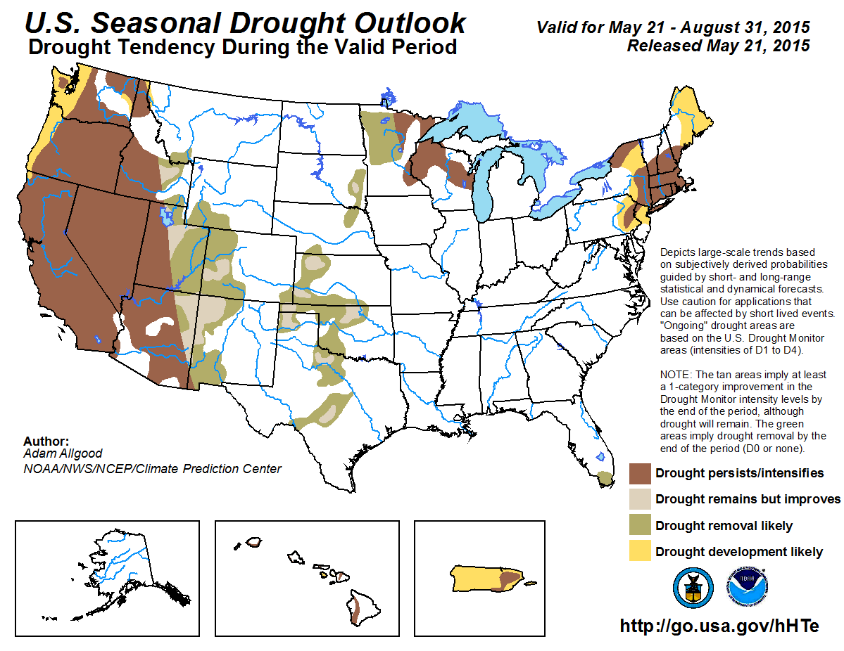
During late Spring, multiple shortwave troughs ejecting over the Plains and interacting with ample Gulf moisture brought widespread, significantly above normal
rainfall to the central and southern Plains. Additionally, heavy snowfall (1 to 2 feet) fell across parts of the northern Plains. This precipitation resulted in
widespread drought reduction and removal across the Plains. Above normal rain and mountain snowfall also fell over the central and southern Rockies, resulting in
more localized drought improvements. In contrast, abnormal dryness coupled with unseasonable May warmth resulted in declining streamflows and drought development
across parts of the Northeast. Drought conditions also worsened across the northwestern quadrant of the Nation, where below normal precipitation provided no
boosts to extremely low mountain snowpack conditions. Although there is not a clear climate anomaly signal favoring below normal precipitation for the Northeast,
current conditions are likely to continue to degrade as evapotranspiration increases during the Summer months. Therefore, drought persistence and further
expansion is forecast for the Northeast where streamflows are already low, although periodic summer thunderstorms may erode drought conditions in many areas
before the end of August. A continuation of above normal precipitation is favored across the central Rockies, central and southern Plains, and southeastern U.S.
during the Summer months, which would favor further drought reductions. Additionally, the onset of the Summer rainy season is likely to remove the lingering
drought area over South Florida. Seasonal dryness, a potential for abnormal warmth, and poor snowpack conditions are likely to result in drought persistence and
intensification across the West, with additional development possible over the Pacific Northwest. Over the Southwest, monsoonal thunderstorms are likely to bring
highly localized relief, but climate anomalies associated with El Niño favor below normal monsoonal rainfall, making persistence the most likely outcome for
Arizona and southeastern California. Suppressed convection is also favored during El Niño summers over the Caribbean, which favors further drought expansion
across Puerto Rico. For Hawaii, although El Niño conditions favor above normal dry season precipitation, it is unlikely to significantly benefit the lingering
leeward drought areas.
|
|
Tools used in the U.S. Seasonal Drought Outlook (SDO) included the official Climate Prediction Center (CPC) temperature and precipitation outlooks for
June 2015 and June-August 2015,
various short- and medium-range forecasts and models such as the 5-day and 7-day precipitation totals forecast (QPFs) from
the Weather Prediction Center (WPC), the 6-10 day and 8-14 day CPC extended-range forecasts (ERFs), the
NAEFS precipitation outlooks, the soil moisture tools
based on the Constructed Analog on Soil Moisture (CAS), dynamical models (CFSv2, NMME, IRI, IMME, and ECMWF), the 384-hour total precipitation forecasts from
several runs of the GFS, the four-month Palmer drought termination and amelioration probabilities, June and June-August climatology, and initial conditions.
An El Niño (ENSO) Advisory is now in effect, with the April 9, 2015 ENSO Diagnostic Discussion indicating a 90 percent chance of El Niño conditions
continuing through Northern Hemisphere summer 2015.
Precipitation deficits have been growing from northern Maryland through New England during the Spring, with 60-day anomalies exceeding 5 inches from northern
New Jersey across southeastern New England. Longer term deficits are also becoming apparent, with year-to-date percent of normal precipitation values
between 50 and 70 percent across much of the region. Unseasonably cold weather slowed snowmelt and evapotranspiration rates during March and April, which
limited impacts; however, recent warmth has accelerated plant growth and soil moisture loss, and streamflow values have been steadily decreasing. Accordingly,
moderate drought (D1) conditions developed across parts of eastern Pennsylvania, New York, and southeastern New England, while abnormal dryness (D0) was
indicated for the remainder of the Northeast. Due to a fairly even distribution of generous climatological rainfall throughout the year, which mitigates the
effects of subseaonal dry spells, prolonged drought conditions are more difficult to maintain across the Northeast than regions with long dry seasons such as
California. Average soil moisture content usually decreases during the summer months across the Northeast, however, which makes the region vulnerable to the
incipient conditions coming out of the Spring months. During the upcoming 7-day period, WPC QPF forecasts indicate widespread light to moderate
precipitation, with accumulations of up to an inch across the interior Northeast, although values decrease to below a half-inch closer to the coast. CPC
6-10 and 8-14 day outlooks show enhanced chances for above-median precipitation across the mid-Atlantic and southern New England. While this forecasted
precipitation during the remainder of May would boost moisture locally, it is unlikely to be sufficient to overturn increasing moisture deficits on a large
scale. Additionally, temperature forecasts for the remainder of May and June depict a climate signal favoring above-median temperatures, which would
continue to promote high evapotranspiration rates. At the seasonal time scale, there is little signal for climate anomalies, as ENSO impacts are less
apparent during the summer months over the Northeast than in winter months. Therefore, the CPC monthly and seasonal outlooks maintain equal chances for
below, near, or above median precipitation. Some dynamical models, such as the CFS, do depict a dry signal across the Northeast during JJA, and the ECMWF
forecast indicates abnormal dryness during the Weeks 3 and 4 period. Based primarily on current conditions, climatological precipitation, and the prospects
for above normal temperatures early in the forecast period, additional drought development is favored for eastern Pennsylvania, northern New Jersey, eastern
New York, and eastern Maine, with persistence favored for existing drought areas. There is reduced confidence for existing or newly developing drought
conditions to persist through the entire summer period, however. Additionally, recent heavy thunderstorm activity across parts of far south-central
Pennsylvania and north-central Maryland make short term drought development there less likely than areas further north and east, so no development was
indicated.
Forecast confidence in the Northeast is low.
Keetch Byram Drought Index values have been increasing across South Florida, where short term moderate drought conditions remain across primarily the
Everglades. The rainy season begins during late May in southern Florida, which should begin to improve the dry Spring conditions. Generally light
(under 0.5 inch) rainfall accumulations are forecast during the upcoming week, although heavier rainfall is forecast across Central Florida. CPC 8-14 day
outlooks maintain near normal precipitation for southern Florida, while the monthly and seasonal outlooks favor near to above median precipitation. Climate
anomalies associated with ENSO conditions also favor enhanced precipitation across Florida. Based on both climatology and these outlooks, drought removal
is anticipated for South Florida.
Forecast confidence in South Florida is high.
A series of shortwave troughs ejecting from the Pacific and interacting with ample Gulf moisture has produced repeated widespread and very heavy
precipitation events across the Plains states. The generous rainfall has resulted in significant large scale drought reductions, particularly across Texas
and Oklahoma, but also unfortunately has caused localized issues with flooding and severe weather. Thirty-day surpluses of 5-10 inches are common across the
eastern two thirds of Texas and much of Oklahoma. Further north, heavy snowfall (1 to 2 feet) fell across parts of Nebraska and the Dakotas, easing drought
conditions there as well. The Spring precipitation events have also improved long term drought conditions across the Great Plains, with surpluses now
observed on the 12 month time scale across Texas, Oklahoma, and western Kansas. Widespread deficits on the 3-year time scale are still present, however, and
reservoirs have been slower to recover than soils and rivers. Therefore, areas of moderate to severe drought with long term impacts only remain on the latest
U.S. Drought Monitor. During the next 7-days, additional widespread heavy rainfall (3-6 inches) is expected from Texas and Oklahoma through the central Corn
Belt. This precipitation will continue the pattern of drought reduction across the central and southern Plains. Accumulations of 0.5 to 1.5 inches are also
forecast across South Dakota and Nebraska, which will continue to erode lingering drought in those states. CPC 8-14 day, monthly, and seasonal outlooks all
indicate enhanced chances for above median precipitation across the central and southern Plains. Below median precipitation is favored across the far
northern Plains during the 8-14 day period, with equal chances for below, near, or above median precipitation thereafter. The summer months are a relatively
wet time of year across the northern Plains, which favors further drought reductions. Based on these outlooks, further improvements or removal of remaining
drought areas are expected.
Forecast confidence in the Plains is moderate to high.
During the past 30 days, above average precipitation fell across much of Minnesota, while below average rainfall persisted across much of Wisconsin. The
summer months are climatologically wet across the upper Midwest, particularly across Minnesota, which would favor drought reduction. Precipitation
accumulations generally under 0.5 inches are forecast during the upcoming week, while the CPC 8-14 day outlooks favor below median precipitation. The
monthly and seasonal outlooks indicate no anomalous climate signals during the summer. ENSO precipitation composites are fairly noisy across the upper
Midwest during the summer months. Based primarily on climatology, therefore, drought removal is anticipated across western and central Minnesota, where the
percent of annual precipitation and positive soil moisture change values are the greatest. Drought persistence is slightly more favored across eastern
Minnesota and Wisconsin, where soil moisture is more likely to decrease during the Summer.
Forecast confidence in the upper Midwest is low to moderate.
Recent cool weather and above normal rainfall resulted in drought improvements across Colorado, eastern Utah, and southeastern Wyoming. In fact, SNOTEL snow
water content (SWE) values across central Colorado are now above normal. In contrast, drier weather promoted expansion of abnormal dryness across much of
Idaho, Montana, and western Wyoming, where snow water content values are considerably lower. During the next 7 days, WPC QPF forecasts indicate widespread
precipitation across much of the Intermountain West and central Rockies. This precipitation would boost moisture across much of Idaho, northern Utah,
Wyoming, and Colorado. The CPC 8-14 day outlook indicates enhanced chances of above median precipitation during Week-2 across the northern and central
Rockies as well. The wet signal is persisted in the CPC monthly and seasonal outlooks as well. Based on these outlooks, drought improvement or removal is
favored for much of the central and northern Rockies, including all of Colorado, eastern Utah, and eastern Idaho. Drought persistence is maintained across
the remainder of the Intermountain West, where current SWE values are much lower and climatological precipitation is less.
Forecast confidence in the northern and central Rockies is moderate.
The Southwest Monsoon season presents difficulties for this outlook when drought is in place, since improvements under a convective regime tend to be spotty
and difficult to pinpoint. CPC monthly and seasonal outlooks indicate enhanced chances for above median precipitation across New Mexico, and equal chances
for below, near, or above median precipitation for Arizona. ENSO composites depict a statistically significant dry climate anomaly across Arizona and New
Mexico during the summer months, corresponding to the early monsoon period. Gulf surges due to tropical cyclone activity over the eastern Pacific may
mitigate this dry signal later in the monsoon season. Based on the ENSO composites and CPC outlooks, drought persistence is forecast for southeastern
California and most of Arizona. Drought improvement or removal is forecast for New Mexico and far northeastern Arizona, although these improvement will be
spotty in nature.
Forecast confidence in the Southwest Monsoon region is moderate.
The dry season is in full swing across the Western U.S., although a series of troughs have brought some moisture to the Cascades, northern Sierras, and
Great Basin. SNOTEL SWE values remain extremely low across the West. 7-day precipitation forecasts indicate another round of decent off-season moisture
across Washington, Oregon, northern California, northern Nevada, and Idaho. The CPC 8-14 day outlook persists this wet pattern for the Great Basin region,
while the monthly and seasonal outlooks both maintain equal chances for below, near, or above median precipitation across the West. While the short term
rainfall may result in localized ephemeral drought relief, the summer climatology favors persistence. Since streams and reservoirs largely rely on snowmelt
for maintenance during the dry season, further drought degradations are also likely throughout the western states. Additional drought expansion is likely
across the Pacific Northwest.
Forecast confidence in the West is high.
Suppressed convection across Puerto Rico resulted in declining streamflow values and an expansion of abnormal dryness (D0) and moderate drought (D1) across
the eastern half of the island. Climate anomalies associated with El Niño strongly favor suppressed convection and reduced tropical cyclone activity across
the Caribbean, and this signal is supported by seasonal dynamical model guidance. Therefore, further drought degradations and expansion are likely across
Puerto Rico, although any summer tropical cyclone impacts could reverse conditions fairly quickly.
Forecast confidence in Puerto Rico is moderate.
Climate anomalies associated with El Niño generally favor above average summer precipitation across the Hawaiian Islands, although the benefits from these
rains are limited due to the dry seasonal climatology. Any potential rainfall would likely have little impact on the remaining moderate drought conditions.
Therefore, drought persistence is maintained for these drought areas, and drought development is possible for leeward portions of Maui County.
Forecast confidence in Hawaii is moderate.
|


