|
Latest Seasonal Assessment -
During the past four weeks, persistently dry, warm weather contributed to an expansion and degradation of drought across the
southern Plains and lower Mississippi Valley away from the immediate Gulf Coast, with many stations across the region recording
top-5 driest Septembers on record. Short term abnormal dryness and areas of moderate drought also developed over parts of the middle
Mississippi Valley. In contrast, excessive rainfall associated with an upper level low and a stalled frontal boundary inundated
parts of the East. In particular, rainfall in excess of 20 inches across central and eastern South Carolina generated widespread
catastrophic flooding. Rainfall also eased drought conditions across the Northeast, but pockets of moderate drought remain in
southeastern New England and the Tri-State region. Abnormal heat dominated the western half of the CONUS, and while most regions
remained status quo with respect to drought, areas of above average precipitation brought relief to parts of southern Arizona and
New Mexico, southern Idaho, and Montana.
Strong El Niño conditions are ongoing across the equatorial Pacific, with robust atmospheric coupling. The latest CPC ENSO
advisory indicates a 95 percent chance that El Niño conditions will persist through the winter months. Therefore, climate
anomalies associated with El Niño events, which become increasingly prominent over the U.S. during the Fall and Winter
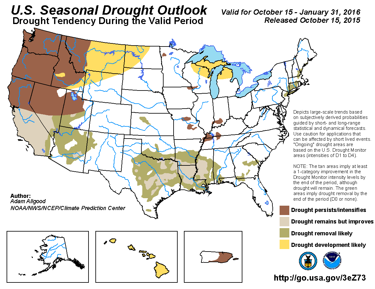
months, played a significant role in this outlook. Through the end of January, widespread drought relief is anticipated across the
central and southern Plains, lower Mississippi Valley, and the eastern U.S. In contrast, a drier ENSO climate signal over the middle
Mississippi and Ohio Valleys makes substantial relief of the short term drought conditions less likely, although there is too much
uncertainty to warrant additional drought expansion in this outlook. Based on the CPC seasonal forecasts, the greatest potential
for drought development is across the northern tier of states, including the Great Lakes region and northern Plains. Drought
persistence or intensification is forecast across the Northwest. For the Southwest, El Niño associated climate anomalies
favor an enhancement of the early wet season. Therefore, drought improvement is favored across central and southern California.
There is greater confidence for improvement across the coastal regions and valleys, whereas significant improvement across the
Sierras relies on colder temperatures to support substantial snowfall. Further east, drought removal or improvement is forecast
across the southern Great Basin and interior deserts. A pronounced dry signal during El Niño years favors drought
development across Hawaii. Drought persistence with no further expansion is forecast across Puerto Rico, where the start of the dry
season may be offset by a wet climate signal during El Niño years. Drought development is not anticipated across Alaska
during the first part of the winter season.
|
|
Tools used in the U.S. Seasonal Drought Outlook (SDO) included the official Climate Prediction Center (CPC) temperature and
precipitation outlooks for November 2015 and November - January (NDJ) 2015-2016, various short- and medium-range forecasts and
models such as the 5-day and 7-day quantitative precipitation forecast (QPF) totals from the Weather Prediction Center (WPC), the
6-10 day and 8-14 day CPC extended-range forecasts (ERFs), the NAEFS (North American Ensemble Forecast System) precipitation
outlooks, the soil moisture tools based on the Constructed Analog on Soil Moisture (CAS), dynamical models (CFSv2, NMME, IRI, IMME,
and ECMWF), the 384-hour total precipitation forecasts from several runs of the GFS, the four-month Palmer drought termination and
amelioration probabilities, climatology for each month and the season as a whole, and initial conditions. An El Niño (ENSO)
Advisory remains in effect, with the October 8, 2015 ENSO Diagnostic Discussion indicating a 95 percent chance of El Niño
conditions continuing through Northern Hemisphere winter 2015-16. Collectively, current oceanic and atmospheric conditions
reflected a strong El Niño, according to the ENSO Diagnostic Discussion, and strong El Niño conditions are expected
to continue for at least the next few months. Additionally, El Niño impacts over the U.S. become increasingly apparent during
the Fall and Winter seasons. Therefore, climate anomalies associated with El Niño played a substantial role in this
outlook.
September and October are the final months of the dry season for California, so any precipitation occurring during this period
would produce very high percent of normal values, even if the amounts are relatively modest. During the first week of October, a
trough of low pressure over the West promoted a flow of tropical moisture that generated unseasonable precipitation across parts
of southern California, including coastal areas near San Diego, and the southern Sierra Nevada Mountains. Although this moisture
was extremely beneficial, it made little to no dent in the ongoing multi-year drought conditions, and therefore the drought
depiction on the U.S. Drought Monitor remained unchanged. The wet season in California begins in November, and climatological
precipitation increases substantially during December and January, so drought reduction would be more likely to occur during these
months. El Niños have historically enhanced the wet season across California through an active Pacific jet, with the highest
climatological anomalies across central and southern California during the NDJ period. This is reflected in the most recent CPC
monthly and seasonal outlooks. Uncertainty about whether the precipitation will be sufficient to begin eroding the largely extreme
to exceptional multi-year drought, and whether temperatures will support for significant snowpack building across the Sierras is
high. The CPC seasonal outlook indicates enhanced chances for above-median temperatures, which is not a good indicator for ideal
snowpack development, but warmer temperatures can potentially be overcome by increased total precipitation amounts due to El
Niño. Based on these considerations, the best chances for drought reduction are in the regions favored for enhanced
precipitation, which are central and southern California. Coastal regions and valleys are more likely to see improvements to soil
moisture and reservoir levels. Drought persistence is maintained for northern California in this outlook, but prospects may improve
during February and March.
Forecast confidence for California is moderate.
Areas of above-normal rainfall associated with tropical moisture entrained by a trough of low pressure brought modest improvements
to areas of drought and abnormal dryness across parts of southern Arizona and New Mexico during the past four weeks. Although not
as wet climatologically as during the monsoon months, Pacific storm systems can generate precipitation over Arizona and the Great
Basin during the Fall and Winter months. Climate anomalies associated with El Niño would favor above average precipitation
across the Southwest. During the next week, widespread moderate to heavy precipitation is forecast across the southern Great Basin
and the Four Corners states. This short term rainfall would continue to bring improvements to drought conditions across the
Southwest. The CPC 8-14 day and November monthly outlooks both favor above-median precipitation for the Four Corners states, and
the seasonal forecast favors above-median precipitation for the southern Great Basin, southern Utah, Arizona, and New Mexico. Based
on these forecasts, drought removal or improvement is forecast across southern Nevada, southern Utah, and all remaining drought
areas of Arizona and New Mexico.
Forecast confidence for the Desert Southwest and Great Basin is moderate to high.
Across the northwestern quadrant of the Nation, early October precipitation eased drought conditions across southern Idaho and
north-central and eastern Montana. Elsewhere, dry, warm weather maintained the status quo for widespread severe to extreme drought
conditions. The November - January period is a climatologically wet time of year across the Northwest, and the period is critical
for snowpack building and reservoir recharge. El Niño conditions are associated with below-normal precipitation across the
Northwest, particularly away from the Pacific coast. Accordingly, both the CPC monthly and seasonal outlooks indicate enhanced
chances for below-median precipitation over much of the interior Northwest, with the highest probabilities centered over the
northern Rockies. The corresponding temperature outlooks depict enhanced chances for above-median temperatures, which may further
limit snowpack development. Therefore, persistence of existing drought areas is anticipated across the Northwest through the end
of January. Additionally the region favored for below-median precipitation in the CPC seasonal outlooks extends eastward to western
North Dakota. Therefore, drought conditions are anticipated to expand eastward across the northern Rockies and possibly across the
northern High Plains during the period.
Forecast confidence for the Northwest is moderate.
Dry, warm conditions during September led to expanding flash drought conditions across the southern Plains and lower Mississippi
Valley. Pine Bluff, AR, Shreveport, LA, and Little Rock, AR all recorded their driest Septembers on record, measuring only 0.03,
0.07, and 0.12 inches of rainfall for the month, respectively. Many other stations across Texas, Louisiana, and Arkansas also
recorded top-5 dry Septembers. Fall and winter climatology is favorable for moisture recharge across the lower Mississippi Valley,
with climatological precipitation decreasing towards the west. Soil moisture almost always increases during the period across
Louisiana, Mississippi, and Arkansas. The El Niño climate signal strongly favors enhanced precipitation across the southern
tier. Although little precipitation is forecast over the next 7 days, which may lead to additional degradation in the short term,
the CPC 8-14 day outlook favors enhanced chances for above-median rainfall. Both the CPC monthly and seasonal outlooks favor
enhanced rainfall as well, with a greater than 50 percent chance of above-median across southern Texas through the end of January
(which corresponds to a less than 17 percent chance of below). Based on the climatology favoring recharge and the strong ENSO
signal and the corresponding CPC long lead outlooks, significant drought reduction is forecast for the southern Plains and lower
Mississippi Valley. A wet signal during El Niño years also favors removal of the small remaining drought area in Kansas.
Further north, there is a tight anomaly gradient during El Niños between enhanced precipitation near the Gulf Coast, and
below normal precipitation across the Midwest and Ohio Valley. The CPC monthly and seasonal outlooks maintain equal chances for
near, above, and below median precipitation across the middle Mississippi and Ohio Valleys, and the various dynamical models and
tools have a mixed signal regarding the strength of the below normal anomaly feature. Generally, the dry signal across the Ohio
Valley becomes more pronounced later in the winter season. Therefore, persistence is indicated for the small areas of moderate
drought across the middle Mississippi and Ohio Valleys, but no additional development is indicated.
Forecast confidence is high for the central and southern Plains and lower Mississippi Valley, and low for the middle Mississippi
and Ohio Valleys.
Areas of abnormal dryness developed over the upper Great Lakes region and upper Midwest during the past four weeks. Abnormally dry
conditions are typical along the northern tier during El Niño Fall and Winter months, and the CPC monthly and seasonal
outlooks both favor below-median precipitation, particularly across the Great Lakes. Based on the incipient dryness and the long
lead outlooks, drought development is favored for the Great Lakes region, from northern Wisconsin through northern Michigan.
Forecast confidence for the Great Lakes region is moderate.
Drought concerns across the Southeast were transformed within a period of a few days into catastrophic flooding across central and
eastern South Carolina, where rainfall in excess of 20 inches fell due to a slow moving, upper-level low-pressure system along a
stalled front. Heavy rainfall fell across much of the eastern seaboard, easing drought conditions. A few areas of drought continue
to linger in northern Florida, Georgia, the Tri-State region (New Jersey, New York, Connecticut), and southeastern New England. El
Niño winters tend to be wet along the East Coast, due to an active and moist southern stream and a displaced storm track
favoring the East Coast. Fall and winter are also climatologically favorable times of year for moisture recharge, due to decreased
evapotranspiration rates. Therefore, removal of the lingering drought areas is likely.
Forecast confidence for the East is high.
El Niño is associated with a suppressed rainy season across Hawaii. Accordingly, the CPC seasonal outlook depicts enhanced
chances for below-median rainfall through January. Based on the climate signal and these outlooks, drought development is likely
across all of Hawaii.
Forecast confidence for Hawaii is moderate to high.
The climatological dry season begins during November in Puerto Rico. El Niño associated climate anomalies favoring
suppressed convection across the Caribbean promoted drought expansion across much of eastern Puerto Rico during the past several
months. During the dry season, El Niño conditions begin to promote wetter than average conditions. The potential for
above-average precipitation will likely prevent further drought expansion or intensification, but due to the drier climatology,
it is uncertain whether significant drought relief will be realized. Therefore, drought persistence is indicated for the existing
drought areas.
Forecast confidence for Puerto Rico is low to moderate.
|


