|
Latest Seasonal Assessment -
Since the previous seasonal outlook release on July 16, unseasonable warmth and subnormal rainfall (e.g. no measureable rain
at DFW, TX, since July 9) have expanded short-term drought across parts of the southern Great Plains, lower Mississippi
Valley, and parts of the Southeast. After a very wet June and July in the Northeast, rains have also been spotty, slightly
increasing abnormal dryness in New England. Similarly, small areas of short-term dryness were found in the upper Midwest. In
contrast, improvement occurred in parts of Florida and southern Georgia from heavy rains, and in portions of the Rockies and
central and northern Plains from a strong flow of Pacific monsoonal moisture. Record July rains fell on parts of southern
California thanks to remnant moisture from Hurricane Delores (e.g. 1.69 inches at San Diego, CA, on July 18-19), but this did
not make a dent in the long-term drought. Short-term drought lingered across parts of Alaska, but rains have increased
lately. Short-term drought continued on the leeward sides of the Hawaiian Islands as remnant tropical moisture in early
August from TS Guillermo kept windward sides drought free. Meanwhile, the drought worsened across the eastern half of Puerto
Rico (and much of the Caribbean) as the quiet 2015 Atlantic tropical season continued, although San Juan did receive its
greatest daily total (1.82 inches) of the year on Aug. 16. The current El Niño event is one of the strongest on record at this
time of the year, and is expected to continue through the winter (90 percent chance) and into the spring (70 percent chance).
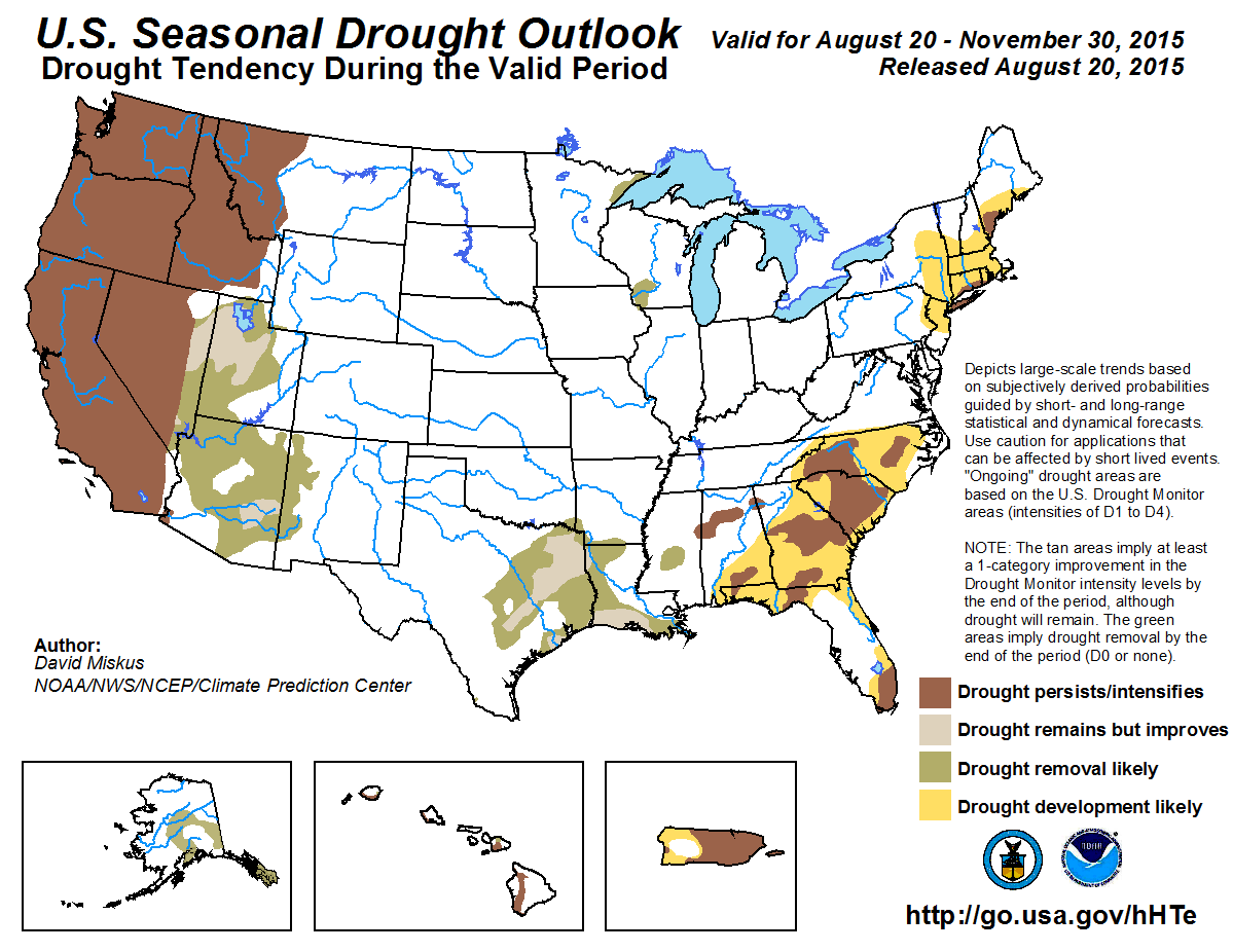
The drought outlook valid from August 20, 2015 through the end of November 2015 is based primarily on initial conditions, the
CPC seasonal (September-October-November (SON)) and monthly (September) precipitation and temperature outlooks, climatology,
and El Niño composites. Although some drought improvement is expected across parts of the Southwest due to increased chances
of enhanced September monsoon rainfall and then later from possible enhancement of the autumn subtropical Pacific jet from the
strong El Niño, long-term hydrological drought is likely to continue in the Far West. Since SON is a climatologically dry for
most of the lower 48 States (although November is wet in the Pacific Northwest), persistence is likely for most of California,
except some possible improvement in the southeastern desert. Persistence and intensification of drought (due to increased
chances of above-normal temperatures and subnormal precipitation during SON) is expected across the Pacific Northwest and into
western Montana.
Due to the very wet spring and early summer across most of the central and eastern U.S., most of the Nation east of the
Rockies was drought-free. However, very dry and warm weather during the past 30 days in the southern Plains, lower Mississippi
Valley, Great Lakes region, and Northeast have developed or expanded short-term abnormal dryness and drought, especially from
the southern Great Plains eastward into the Carolinas. September precipitation odds favor sub-median rainfall along the
eastern Gulf and southern Atlantic Coast States, along with above-normal temperatures. Since October and November are
climatologically drier than September, and an enhanced sub-tropical jet would most-likely favor areas farther to the west,
drought that persists or develops early in the SON period in eastern sections (Georgia-Carolinas-Florida) should linger to the
end of November. In contrast, the increased odds for above-median precipitation in western areas (Texas-Louisiana-Arkansas)
are due to September monsoonal moisture and a possible El Ni&mtilde;o enhanced sub-tropical jet later, allowing for more and earlier
chances of moisture to improve the drought during the SON period. In Florida, a normally wet September combined with
sub-median precipitation probabilities (and quiet Atlantic tropical season) favors drought continuation and expansion. In the
Northeast, dryness is favored during SON based upon strong El Niño analogs, hence drought persistence and expansion was made.
Drought removal is expected across Alaska as September is climatologically wet and the monthly precipitation outlook favors
above-median totals (as does SON along the southern coast). The areas of moderate drought along the leeward sides of the
Hawaiian Islands is forecast to persist as above-median September rainfall should be limited to the windward, east-facing
slopes. This should eliminate some small D1 areas on Maui's and Kauai's windward sides. Concerns for expansion of Hawaiian
drought during the winter and spring months are possible as strong El Ni&mtilde;os tend to bring reduced rainfall. In Puerto Rico,
suppression of summer convection has continued, including minimal tropical cyclone activity across the Caribbean region which
is typical during El Niño summers. Therefore, barring any unforeseen tropical system(s), drought persistence with some
expansion is the most likely outcome across Puerto Rico.
|
|
Tools used in the U.S. Seasonal Drought Outlook (SDO) included the official Climate Prediction Center (CPC)
temperature and precipitation outlooks for September 2015 and September-October-November (SON) 2015,
various short- and medium-range forecasts and models such as the 5-day and
7-day precipitation totals forecast (QPFs) from the Weather Prediction Center (WPC), the 6-10 day and 8-14 day CPC
extended-range forecasts (ERFs), the NAEFS precipitation outlooks,
the soil moisture tools based on the Constructed Analog on Soil Moisture (CAS),
dynamical models (CFSv2, NMME, IRI, IMME, and ECMWF), the 384-hour total precipitation forecasts from several runs of the GFS,
the four-month Palmer drought termination and amelioration probabilities, September and SON climatology, and initial
conditions. An El Niño (ENSO) Advisory continues in effect, with the August 13, 2015 ENSO Diagnostic Discussion indicating a
90 percent chance of El Niño conditions continuing through Northern Hemisphere winter 2015-16, and 85 percent chance it will
last into early spring 2016. This El Niño is one of the strongest on record for this time of the year (mid-August).
Improvement or removal of drought across the Arizona, New Mexico, Utah, and eastern Nevada is based on short-term and
extended-range precipitation forecasts, increased chances for above-median precipitation in CPC's September and SON outlooks,
and late August and September wet climatology. Similar to what remnant moisture from former Hurricane Delores dropped on
normally arid southern California during mid-July, the active East Pacific hurricane season is expected to continue due to the
ongoing El Niño and above-normal sea surface temperatures during the outlook period. With the relatively strong wet signal
among the precipitation tools, a less severe and shorter drought as compared to California, forecast confidence is a bit
higher here than to the west. A significant increase in reservoir levels across the Southwest is not expected until an
adequate winter snowfall season occurs. With the CPC September and SON outlooks favoring above-median precipitation across
the eastern Great Basin (which is not in as severe of drought as western sections), improvement or removal is the probable
outcome in this region.
Forecast confidence for the Southwest and Great Basin is moderate.
September and October are a dry time of year across California (known for hot Santa Ana winds and wild fire season), while
November normally marks the commencement of cold season precipitation, especially in northern sections. With the monthly and
seasonal precipitation outlooks keeping above-median odds in extreme southern sections (and EC elsewhere), drought persistence
is strongly favored for the rest of the State. Any drought removal, associated with monsoon rainfall and tropical cyclone
activity across the East Pacific, is expected to be limited to the southeast California desert (some of which is currently
drought free).
Forecast confidence for California is high.
During the past several months, drought expanded or intensified across the Pacific Northwest, Idaho, and western Montana.
Washington and Oregon observed its warmest May-July on record, and Idaho the fifth warmest. The September to November
climatology increasingly becomes wetter, and with the SON outlooks tilting toward sub-median precipitation and above-normal
temperatures, this could result in further intensification of drought. In western Montana, the SON precipitation consensus is
somewhat weak among tools, but becomes stronger for a dry signal (northern Rockies) as the winter season continues during
an El Niño. With the increased chances for above-normal temperatures during SON and increasing odds for winter dryness,
persistence is favored across western Montana.
Forecast confidence for persistence or intensification across the Pacific Northwest and western Montana is high.
Areas of short-term moderate drought exist in northeastern Minnesota and southwestern Wisconsin. Short-term and
extended-range rainfall, lower autumn temperatures and evapotranspiration, and increased chances for
above-median precipitation in the strong El Niño composites during SON favors elimination of these small D1 areas.
Forecast confidence for northeastern Minnesota and southwestern Wisconsin is moderate.
With recent (30-days) dryness and above-normal temperatures, the U.S. Drought Monitor has somewhat expanded both short and
long-term abnormal dryness and drought across eastern New England and Long Island after some improvements were made a month
ago due to a wet June and early July, this coming on the heels of a dry spring. These back and forth drought changes are
expected to tilt toward additional drought expansion across the Northeast as favored by the SON precipitation outlook and the
El Niño composites (both forecasting sub-median totals). The probabilities then favor wetness during the winter along the
Atlantic Coast due to the expected enhanced sub-tropical jet (storm track) from El Niño off the East Coast.
Forecast confidence for the Northeast is moderate.
Spotty late spring and summer rainfall coupled with above-normal temperatures resulted in short-term drought development
across parts of Mississippi eastward into the Carolinas, and northern and southern Florida. A cold front is expected to focus
convection (1 to 2 inches) this week across most of the Southeast, then odds favor drier and cooler weather into early
September. September precipitation odds favor sub-median rainfall along the eastern Gulf and southern Atlantic Coast States,
along with above-normal temperatures, based upon the quiet Atlantic tropical season (Sep. 10 is the peak date). Since October
and November are climatologically drier than September, and an enhanced sub-tropical jet (from El Niño) would most-likely
favor areas farther to the west, drought that persists or develops early in the SON period in eastern sections
(Georgia-Carolinas-Florida) should linger to the end of November. In Florida, a normally wet September combined with
sub-median precipitation probabilities (and quiet Atlantic tropical season) favors drought continuation and expansion.
Forecast confidence is low to moderate across the Southeast.
In contrast to the Southeast, the increased odds for above-median precipitation in western areas (Texas-Louisiana-Arkansas)
are due to eastward-directed September monsoonal moisture combined with cold fronts, and a possible El Niño enhanced
sub-tropical jet later, allowing for more and earlier chances of precipitation to improve the drought during the SON period.
This forecast, however, is tricky due to the timing of expected enhanced precipitation causes - since the enhanced
sub-tropical jet (and odds for wetness) will be more likely later during the winter months.
Forecast confidence is low for the southern Great Plains and lower Mississippi Valley.
A lack of snowfall this past winter, a relatively dry spring, continued above-normal temperatures, and near-record wild fires
resulted in drought development across parts of Alaska since the previous outlook. Fortunately, rainfall has increased in
coverage and amounts since the last Drought Outlook. With favorable chances (greatest along the southern coast) for
above-median September and SON precipitation, prospects for drought amelioration are best for the Alaska Panhandle and
Kenai Peninsula, and good for interior sections as temperatures cool during the fall months as the frequency of storms
increase. Climatologically, September is quite wet, with October and November still wet along the southern coasts.
Forecast confidence is moderate for Alaska.
For Hawaii, there is a tendency toward wetter conditions during El Niño summers and drier conditions during El Niño winters.
Since this is the fall outlook, Hawaii will most-likely transition from possible wetness to dryness during this season.
However, with recent active tropical activity (e.g. moisture from Guillermo) expected to continue in the central Pacific,
and trade winds occurring about 90 percent of the time, any excess moisture will fall on the windward (east-facing) slopes of
the Islands. Therefore, the small D1 areas on Maui and Kauai are forecast for removal while the leeward side drought will
likely persist into the end of November - and then there will be concern for drought during the winter.
Forecast confidence in Hawaii is moderate.
Suppressed convection across much of Puerto Rico and the Caribbean has resulted in rapidly deteriorating conditions. As of
August 15, San Juan has recorded 8.53 inches since April 1, accumulating a deficit of more than 14 inches. On August 16,
however, San Juan measured 1.82 inches of rain, the greatest daily total this year. Climate anomalies associated with El Niño
strongly favor suppressed convection and reduced tropical cyclone activity across the Caribbean, and this signal is supported
by dynamical model guidance. Therefore, drought is expected to persist or develop across much of Puerto Rico. However, the wet
climatology during SON may provide short-term relief such as an increase in topsoil moisture, or an unexpected tropical storm
(e.g. recently formed Tropical Storm Danny) could dump enough rain on the island to improve conditions.
Forecast confidence in Puerto Rico is moderate.
|


