Tropical Intraseasonal Activity
(Madden-Julian Oscillation- MJO)
What are Intraseasonal Oscillations?
How do scientists detect intraseasonal oscillations
(also called MJO) and predict their evolution?
Why is predicting intraseasonal
oscillations events important?
What is the relationship between tropical intraseasonal
oscillations and El Niño/ La Niña?
What are the impacts of intraseasonal oscillations
on the U.S.? When do they occur?
What is the typical scenario linking intraseasonal
oscillations to heavy precipitation events in the western U.S.?
Do intraseasonal oscillations influence the weather
during the summer months?
What are
Intraseasonal Oscillations?
Variability in weather and climate is pervasive. This variability
ranges over many time and space scales, from small-scale weather phenomena such as wind
gusts, localized thunderstorms, and tornadoes to larger-scale features such as
low-pressure and high-pressure weather systems, to even more prolonged features such as
droughts and floods, to longer-lived climate phenomenon such as El Niño and La Niña, to
even longer decadal trends. In general, the longer time-scale phenomena are often
associated with changes in the atmospheric circulation that encompass areas far larger
than a particular affected region. At times these persistent circulation features occur
simultaneously over vast parts of the hemisphere, or even the globe, and result in
abnormal weather, temperature and rainfall patterns in many regions. Scientists have
discovered that important aspects of this variability are linked to global-scale phenomena
that affect the distribution and intensity of tropical rainfall, thereby influencing the
position and intensity of the subtropical high pressure regions and mid-latitude jet
streams.
Year-to-year (interannual) variability in tropical rainfall is often
related to the occurrence of either the El Niño or La Niña phenomenon in the tropical
Pacific. There is also strong decade-to-decade variability in tropical rainfall, which is
thought to be an important source of interdecadal trends for the atmospheric circulation
and associated weather patterns.
Tropical rainfall also exhibits strong variability on sub-seasonal time
scales. These fluctuations in tropical rainfall often go through an entire cycle in 30-60
days, and are referred to as "intraseasonal oscillations". Four other terms that are
often used interchangeably to refer to intraseasonal oscillations are "Madden-Julian Oscillation"
or "MJO", "30-60 day oscillation", and "30-60 day wave". In this summary we will
refer to this phenomenon by "intraseasonal oscillation" or the "MJO".
The MJO is a naturally occurring component of our coupled
ocean-atmosphere system. It significantly affects the atmospheric circulation throughout
the global Tropics and subtropics, and also strongly affects the wintertime jet stream and
atmospheric circulation features over the North Pacific and western North America. As a
result, it has an important impact on storminess and temperatures over the U.S. During the
summer the MJO has a modulating effect on hurricane activity in both the Pacific and
Atlantic basins. Thus, it is very important to monitor and predict MJO activity, since
this activity has profound implications for weather and short-term climate variability
through the year.
The MJO is characterized by an eastward progression of large regions of
both enhanced and suppressed tropical rainfall, observed mainly over the Indian Ocean and
Pacific Ocean. The anomalous rainfall is usually first evident over the western Indian
Ocean, and remains evident as it propagates over the very warm ocean waters of the western
and central tropical Pacific. This pattern of tropical rainfall then generally becomes
very nondescript as it moves over the cooler ocean waters of the eastern Pacific but
reappears over the tropical Atlantic and Indian Ocean. Each cycle lasts approximately
30-60 days
There are distinct patterns of lower-level and upper-level atmospheric
circulation anomalies which accompany the MJO-related pattern of tropical rainfall. These
circulation features extend around the globe and are not confined to only the eastern
hemisphere. Thus, they provide important information regarding the regions of ascending
and descending motion associated with particular phases of the oscillation over those
parts of the tropics where rainfall is generally low or absent.
There is strong year-to-year variability in MJO activity, with long
periods of strong activity followed by periods in which the oscillation is weak or absent.
This interannual variability of the MJO is partly linked to the ENSO cycle. Strong MJO
activity is often observed during weak La Niña years or during ENSO-neutral years, while
weak or absent MJO activity is typically associated with strong El Niño episodes.
How do scientists detect intraseasonal oscillations
(also called MJO) and predict their evolution?
Due to its slowly evolving nature, accurate prediction of the MJO is
fundamentally related to our ability to monitor the feature and to assess its relative
position and strength. Dynamical models generally do not predict the MJO well, partly
because of the inherent difficulties that still remain regarding the correct mathematical
treatment of tropical convective (rainfall) processes.
Meteorologists use a variety of data and analysis techniques to
monitor, study and predict tropical intraseasonal oscillations and their evolution. Of
primary importance is information derived from NOAA=s
polar-orbiting and geostationary satellites. Satellite-derived data are used to indicate
regions of strong tropical convective activity, and regions in which the convective
activity departs substantially from the long-term mean. These departures from normal are a
fundamental diagnostic tool that is used directly to monitor and predict the MJO as it
propagates around the global tropics.
A second fundamental data source used to monitor the MJO is the global
radiosonde network which provides crucial information regarding the atmospheric winds,
temperature, moisture, and pressure at many levels of the atmosphere. These data are taken
twice daily, and assimilated by dynamical weather prediction models into formats that are
highly efficient for climate analysis and numerical weather prediction. In combination
with the satellite-derived rainfall and convection patterns, these observations provide
meteorologists with the capability to routinely monitor and assess the MJO and its
evolution. It also allows one to better assess the impacts of the MJO activity on features
such as the wintertime jet streams, and the large-scale environment within which tropical
storms and hurricanes develop over the tropical Atlantic.
There are several diagnostic analyses which allow us to directly
monitor the MJO. These analyses are often displayed in time-longitude format so as to
reveal the propagation, amplitude and location of the MJO-related features. Typical
time-longitude sections include 1) Outgoing Longwave Radiation, which is a
satellite-derived measure of tropical convection and rainfall, 2) velocity potential,
which is a derived quantity that isolates the divergent component of the wind at upper
levels of the atmosphere, 3) upper-level and lower-level wind anomalies and 4) 500-hPa
height anomalies to represent the atmospheric responses in midlatitudes.
Why is predicting intraseasonal oscillations events
important?
The MJO can have significant impacts on the wintertime atmospheric
circulation over the North Pacific and western North America. It is also a contributor to
blocking activity (i.e. atmospheric circulation features that persist near the same
location for several days or more) and block evolution over the high latitudes of the
North Pacific, which is another important component of winter weather patterns over North
America. Thus, improved monitoring and understanding of the MJO and its impacts on these
circulation features can help meteorologists to better predict their evolution. This
improved prediction of features such as blocking activity, etc. is important since the
dynamical prediction of block evolution beyond several days remains a large source of
uncertainty in numerical models.
The phase of the MJO is also extremely important for assessing whether
conditions are conducive to tropical storm development over the tropical and subtropical
North Pacific and North Atlantic ocean basins. For example, MJO-related descending motion
over the tropical Atlantic is not favorable for tropical storm development, whereas
MJO-related ascending motion over the North Atlantic is quite favorable for tropical storm
development. The MJO is monitored routinely by both the Hurricane Prediction Center and
the Climate Prediction Center during the Atlantic hurricane season to aid in anticipating
periods of relative activity or inactivity.
What is the relationship between tropical
intraseasonal oscillations and El Niño/ La Niña?
Intraseasonal oscillations often exhibit a strong relationship to the
phase of the ENSO cycle. Overall, there tends to be weak or absent MJO activity during
moderate or strong El Niño episodes. In contrast, MJO activity is often substantial
during ENSO-neutral years and during weak La Niña episodes.
What are the impacts of intraseasonal
oscillations on the U.S.? When do they occur?
The strongest impacts of intraseasonal variability on the U.S.
occur during the winter months over the western U.S. During the winter this region
receives the bulk of its annual precipitation. Storms in this region can last for several
days or more and are often accompanied by persistent atmospheric circulation features. Of
particular concern are the extreme precipitation events which are linked to flooding.
There is strong evidence for a linkage between weather and climate in this region from
studies that have related the El Niño-Southern Oscillation (ENSO) to regional
precipitation variability. From these studies it is known that extreme precipitation
events can occur at all phases of the El Niño-Southern Oscillation (ENSO) cycle, but the
largest fraction of these events occur during La Niña episodes and during ENSO-neutral
winters.
During La Niña episodes much of the Pacific Northwest experiences
increased storminess, increased precipitation and more overall days with measurable
precipitation. The risk of flooding in this region increases as the strength of the
cold episode decreases due to an increase in extreme precipitation events in the
weaker episodes. In the tropical Pacific, winters with weak-to-moderate cold episodes, or
ENSO-neutral conditions are often characterized by enhanced 30-60 day MJO activity. A
recent example is the winter of 1996/97, which featured heavy flooding in California and
in the Pacific Northwest (estimated damage costs of $2.0-3.0 billion at the time of the
event) and a very active MJO. Such winters are also characterized by relatively small sea
surface temperature anomalies (SSTA) in the tropical Pacific compared to stronger warm and
cold episodes. In these winters there is a stronger linkage between the MJO events and
extreme west coast precipitation events (Fig.
1).
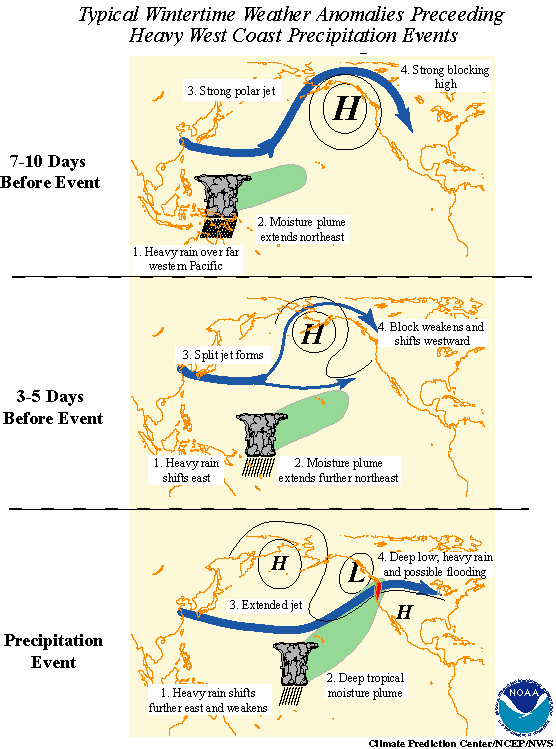
What is the typical scenario linking intraseasonal
oscillations to heavy precipitation events in the western U.S.?
The typical scenario linking the pattern of tropical rainfall
associated with the MJO to extreme precipitation events in the Pacific Northwest features
a progressive (i.e. eastward moving) circulation pattern in the tropics and a retrograding
(i.e. westward moving) circulation pattern in the midlatitudes of the North Pacific (Fig. 1). Typical wintertime weather
anomalies preceding heavy precipitation events in the Pacific Northwest are as follows:
(1) 7-10 days prior to the heavy precipitation event:
Heavy tropical rainfall associated with the MJO shifts eastward from
the eastern Indian Ocean to the western tropical Pacific. A moisture plume extends
northeastward from the western tropical Pacific towards the general vicinity of the
Hawaiian Islands. A strong blocking anticyclone is located in the Gulf of Alaska with a
strong polar jet stream around its northern flank.
(2) 3-5 days prior to the heavy precipitation event:
Heavy tropical rainfall shifts eastward towards the date line and
begins to diminish. The associated moisture plume extends further to the northeast, often
traversing the Hawaiian Islands. The strong blocking high weakens and shifts westward. A
split in the North Pacific jet stream develops, characterized by an increase in the
amplitude and areal extent of the upper tropospheric westerly zonal winds on the southern
flank of the block and a decrease on its northern flank. The tropical and extratropical
circulation patterns begin to "phase", allowing a developing midlatitude trough
to tap the moisture plume extending from the deep tropics.
(3) The heavy precipitation event
As the pattern of enhanced tropical rainfall continues to shift further
to the east and weaken, the deep tropical moisture plume extends from the subtropical
central Pacific into the midlatitude trough now located off the west coast of North
America. The jet stream at upper levels extends across the North Pacific with the mean jet
position entering North America in the northwestern United States. Deep low pressure
located near the Pacific Northwest coast can bring up to several days of heavy rain and
possible flooding. These events are often referred to as "pineapple express"
events, so named because a significant amount of the deep tropical moisture traverses the
Hawaiian Islands on its way towards western North America.
Throughout this evolution, retrogression of the large-scale atmospheric
circulation features is observed in the eastern Pacific-North American sector. Many of
these events are characterized by the progression of the heaviest precipitation from south
to north along the Pacific Northwest coast over a period of several days to more than one
week. However, it is important to differentiate the individual synoptic-scale storms,
which generally move west to east, from the overall large-scale pattern which exhibits
retrogression.
There is a coherent simultaneous relationship between the longitudinal
position of maximum MJO-related rainfall and the location of extreme west coast
precipitation events. Extreme events in the Pacific Northwest are accompanied by enhanced
precipitation over the western tropical Pacific and Indonesia (typically centered near 120oE)
with suppressed precipitation over the Indian Ocean and the central Pacific. As the region
of interest shifts from the Pacific Northwest to California, the region of enhanced
tropical precipitation shifts further to the east. For example, extreme rainfall events in
southern California are typically accompanied by enhanced precipitation near 170oE.
However, it is important to note that the overall linkage between the MJO and extreme
west coast precipitation events weakens as the region of interest shifts southward along
the west coast of the United States. A summary of the simultaneous relationship
between the location of maximum MJO-related rainfall and heavy rainfall in west coast of
the U.S. is as follows:
west coast location
longitude of maximum MJO-related rainfall
western Washington:
120°E
northwestern Oregon
125°E
southwestern Oregon
130°E
northwestern California
140°E
north central California
150°E
west central California
160°E
southwestern California
165°E
southern California
170°E
It should be noted that there is case-to-case variability in the
amplitude and longitudinal extent of the MJO-related precipitation, so this should be
viewed as a general relationship only.
Do intraseasonal oscillations influence the weather
during the summer months?
The North American warm season precipitation regime experiences
climate variations on time scales ranging from intraseasonal to decadal. During the summer
months low-frequency variability in the tropics is dominated by interannual variations
associated with ENSO and by intraseasonal variations such as the MJO. Both of these
phenomena feature near-global patterns of anomalous atmospheric circulation that are
closely related to variations in precipitation in many regions of the tropics and
subtropics. The MJO can have a significant impact on regions that experience rainy
seasons both during winter and summer seasons. For example, during the Northern Hemisphere
summer season the MJO-related effects on the Indian summer monsoon are well documented.
MJO-related effects on the North American summer monsoon also occur, though they are
relatively weaker. However, the relative influences of ENSO and the MJO on the summer
precipitation regime of North America are not well understood.
MJO-related impacts on the North American summer precipitation patterns
are strongly linked to meridional (i.e. north-south) adjustments of the precipitation
pattern in the eastern tropical Pacific. A strong relationship between the leading mode of
intraseasonal variability of the North American Monsoon System, the MJO and the points of
origin of tropical cyclones is also present.
Although tropical cyclones occur throughout the NH warm season
(typically May-November) in both the Pacific and the Atlantic basins, in any given year
there are periods of enhanced / suppressed activity within the season. There is evidence
that the MJO modulates this activity (particularly for the strongest storms) by providing
a large-scale environment that is favorable (unfavorable) for development (Fig. 2). The strongest tropical cyclones tend to develop when
the MJO favors enhanced precipitation. As the MJO progresses eastward, the favored region
for tropical cyclone activity also shifts eastward from the western Pacific to the eastern
Pacific and finally to the Atlantic basin. While this relationship appears robust, we
caution that the MJO is one of many factors that contribute to the development of tropical
cyclones. For example, it is well known that SSTs must be sufficiently warm and vertical
wind shear must be sufficiently weak for tropical disturbances to form and persist.


