| SUMMARY
There is a 45% probability of a near-normal Atlantic hurricane season in 2002, a
35% probability of an above-normal season, and a 20% chance of a below-normal season,
according to a consensus of scientists at the National Oceanic and Atmospheric
Administration's (NOAA) Climate Prediction Center (CPC), the Hurricane Research Division
(HRD), and the National Hurricane Center (NHC). This outlook represents
the mixed combination of weak El Niño conditions and ongoing
decadal-scale anomalies that are more conducive to an above-normal season.
The projected 2002 activity is centered approximately on the border between a near
normal and an above-normal season, with a somewhat higher probability of being in the
near-normal range. The 2002 season is not expected to be extremely active, as was observed
during four of the last seven seasons (1995, 1996, 1998, 1999). However, it is expected to be more active than
most of the relatively quiet 1971-1994 period.
DISCUSSION
1. Expected Level of Overall Activity - Near-normal
to slightly above normal
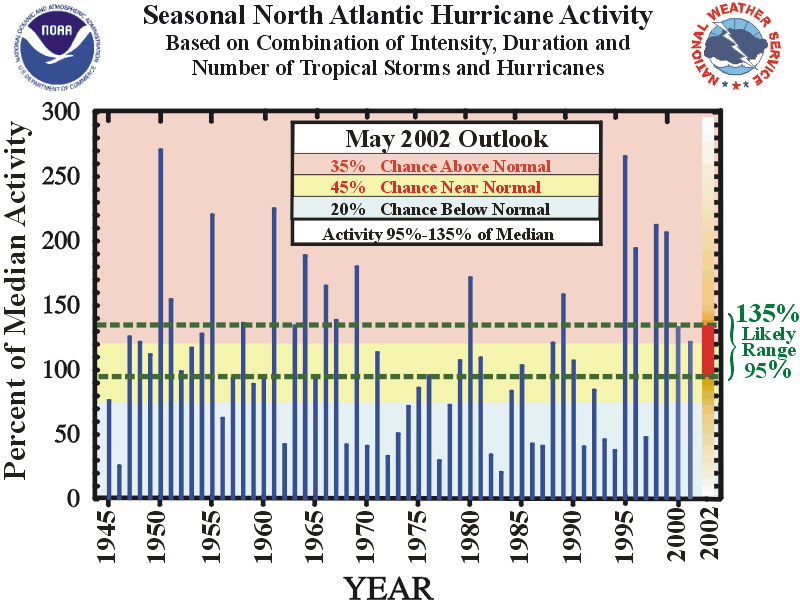
Based on the current and
expected climate conditions there is a 45% probability of a near-normal Atlantic hurricane
season in 2002, a 35% probability of an above-normal season, and a 20% chance of a
below-normal season. Using the
"Accumulated Cyclone Energy" (ACE) index as the basis for measuring overall
seasonal activity (see Background Information),
the total 2002 activity is expected to range between 95%-135% of the long-term median ACE
value (Fig. 1). This
predicted range is centered slightly below the border (120% of median) between near normal
and above normal activity, and emphasizes the higher probability of the near-normal range.
The historical record
indicates a likely range of 9-13 tropical storms this season, which reflects larger
uncertainty in the number of named storms when no significant El Nino or La Nina is
present. The historical record also indicates
that 85% of comparable seasons featured 6-8 hurricanes, and 70% featured 2-3 major
hurricanes [categories 3-4-5 on the Saffir-Simpson scale]. Only 55% of these seasons
yielded the combination of 9-13 tropical storms, 6-8 hurricanes and 2-3 major hurricanes.
Thus, while it is reasonable to expect the above range of tropical storms and
hurricanes, the season can certainly feature near-to slightly above- normal levels of
activity without all three of these criteria being met.
Based on past historical
data similar seasons have also averaged 2 landfalling hurricanes in the continental
United States and 1-2 hurricanes in the region around the Caribbean Sea. However, it is important to recognize that it is
currently not possible to confidently predict at these extended ranges the number of U.S.
landfalling hurricanes, the intensity of the landfalling hurricanes, or whether a
particular locality will be impacted by a hurricane this season.
2. Expected Climate Conditions-
Weak El Nino-related impacts expected to be minimal
The ongoing multi-decadal signal that is conducive to increased
hurricane activity, combined with a developing weak El Niño with minimal expected
impacts, will likely result in overall levels of activity approximately bordering between
a near-normal and above-normal season. The
impacts from these climate conditions are expected to be approximately similar to those
observed during the 2001 season.
For the past several hurricane seasons the favorable decadal
signal has been evident in above-normal North Atlantic sea-surface temperatures, in an
overall amplified West African monsoon system, in a favorable configuration of the African
easterly jet, and most importantly in reduced vertical wind shear over the heart of the
hurricane development region. Similar
conditions contributed to the active decades of the 1950's and 1960's, and to the dramatic
upturn in hurricane activity observed since 1995. See
the recent paper by Goldenberg et al. (2001) in Science for more details.
A secondary climate factor, anomalously westerly winds in the
lower stratosphere, is expected to provide a slightly enhancing influence on overall
Atlantic hurricane activity this season.
Collectively, these climate conditions indicate a 45% chance of a near-normal hurricane
season, a 35% chance of an above-normal season, and a 20% chance of a below-normal season.
3. Uncertainties in the Outlook
This outlook is based on the expectation of continued weak El
Niño conditions, coupled with a modestly active multi-decadal signal, during the normal
August-October peak in Atlantic hurricane activity. The
main uncertainty for this outlook is the El Niño intensity during these three months.
If the El Niño becomes stronger than expected it
would likely increase the vertical wind shear in the heart of the hurricane development
region and cause a decrease in overall activity.
We will closely monitor these evolving climate conditions prior to the
release of an updated outlook in early August, which is the traditional beginning of the
active portion of the Atlantic hurricane season.
CAUTIONARY NOTES
1) It is important to recognize that it is
currently not possible to confidently predict at these extended ranges the number of U.S.
landfalling hurricanes, the intensity of the landfalling hurricanes, or whether a
particular locality will be impacted by a hurricane this season.
Therefore, residents and government agencies
coastal and near-coastal regions should always maintain hurricane preparedness efforts
regardless of the overall seasonal outlook
2) Far more damage can be done by one
major hurricane hitting a heavily populated area than by several hurricanes hitting
sparsely populated areas or, of course, not making landfall at all. Therefore, hurricane-spawned disasters can occur
even in years with near-normal or below-normal levels of activity. Examples of years
with near-normal levels of activity that featured extensive hurricane damage and numerous
fatalities include 1960 (Hurricane Donna), 1979 (Hurricanes David and Frederic), and 1985
(Hurricanes Elena, Gloria and Juan). Moreover,
the nation's most damaging hurricane, Andrew in 1992, occurred during a season with
otherwise below normal overall activity.
FORECASTERS
Dr. Lixion Avila, Meteorologist, National Hurricane
Center; ph: 305-229-4410; lixion@nhc.noaa.gov
Dr. Gerald Bell, Meteorologist, Climate Prediction
Center; ph: 301-763-8000 x7536; gerry.bell@noaa.gov
Dr. Muthuvel Chelliah, Physical Scientist, Climate
Prediction Center; ph: 301-763-8000 x 7546; muthuvel.chelliah@noaa.gov
Mr. Stanley Goldenberg, Meteorologist, Hurricane
Research Division; ph: 305-361-4362; stanley.goldenberg@noaa.gov
Dr. Christopher Landsea, Meteorologist, Hurricane
Research Division; ph: 305-361-4357; chris.landsea@noaa.gov
Dr. Richard Pasch, Meteorologist, National
Hurricane Center; ph: 305-229-4411; richard@nhc.noaa.gov |


