|
The 2012 Atlantic hurricane season outlook is an official product of
the National Oceanic and Atmospheric Administration (NOAA) Climate Prediction Center (CPC). The outlook is produced in
collaboration with hurricane experts from the National Hurricane Center (NHC) and the Hurricane Research Division (HRD). The
Atlantic hurricane region includes the North Atlantic Ocean, Caribbean Sea, and Gulf of Mexico.
Interpretation of NOAA’s Atlantic hurricane season outlook
This outlook is a general guide to the expected overall activity during the upcoming hurricane season. It is not a seasonal
hurricane landfall forecast, and it does not predict levels of activity for any particular region.
Preparedness
Hurricane disasters can occur whether the season is active or relatively quiet. It only takes one hurricane (or tropical storm)
to cause a disaster. Residents, businesses, and government agencies of coastal and near-coastal regions are urged to prepare
for every hurricane season regardless of this, or any other, seasonal outlook. NOAA, the Federal Emergency Management Agency
(FEMA), the National Hurricane Center (NHC), the Small Business Administration, and the American Red Cross all provide
important hurricane preparedness information on their web sites.
NOAA does not make seasonal hurricane landfall predictions
NOAA does not make seasonal hurricane landfall predictions. Hurricane landfalls are largely determined by the weather patterns
in place as the hurricane approaches, which are only predictable when the storm is within several days of making landfall.
Nature of this Outlook and the "likely" ranges of activity
This outlook is probabilistic, meaning the stated “likely” ranges of activity have a certain likelihood of occurring. The
seasonal activity is expected to fall within these ranges in 70% of seasons with similar climate conditions and uncertainties
to those expected this year. They do not represent the total possible ranges of activity seen in past similar years.
This outlook is based on 1) predictions of large-scale climate factors known to influence seasonal hurricane activity, 2)
current and evolving atmospheric and oceanic conditions, and 3) climate models that directly predict seasonal hurricane
activity.
Sources of uncertainty in this seasonal outlook
1. Predicting the strength of El Niño and its impacts is an ongoing scientific challenge facing climate scientists today. Such
predictions are even more challenging when there are competing climate factors.
2. Many combinations of named storms and hurricanes can occur for the same general set of climate conditions. For example, one
cannot know with certainty whether a given climate signal will be associated with several short-lived weaker storms or fewer
longer-lived stronger storms.
3. Seasonal model predictions of sea-surface temperatures, vertical wind shear, moisture, and atmospheric stability have
limited skill.
4. Weather patterns that are unpredictable on seasonal time scales can sometimes develop and last for weeks or months,
possibly affecting seasonal hurricane activity.
2012 Atlantic Hurricane Season Outlook: Summary
NOAA’s updated 2012 Atlantic Hurricane Season Outlook indicates a high likelihood (85% chance) of a
near- or above-normal season. The outlook calls for a 50% chance of a near-normal season, a 35% chance of an above normal
season, and only a 15% chance of a below-normal season. See NOAA definitions
of above-, near-, and below-normal seasons. The Atlantic hurricane region includes the North Atlantic Ocean, the Caribbean Sea,
and the Gulf of Mexico.
All indications are that the 2012 Atlantic hurricane season will reflect competing factors, some supporting stronger hurricane
activity and some likely suppressing hurricane activity later in the season.
Favoring more activity are very conducive conditions now in place, which are linked to the ongoing the
tropical multi-decadal signal. This climate pattern has been associated with increased Atlantic
hurricane activity since 1995. It is linked to above-average sea surface temperatures (SSTs) across the tropical Atlantic
Ocean and to an enhanced west African monsoon, both of which are in place as was predicted in the May pre-season outlook.
El Niño is a competing factor that acts to suppress Atlantic hurricane activity by increasing the vertical wind shear over the
tropical Atlantic. The timing of El Niño is very important to this outlook. El Niño is expected to
develop during August or September, but its suppressing influence is not expected until later in
the season. The possibility of near-average SSTs in the far eastern tropical Atlantic also suggests a more moderate hurricane
season.
Based on these competing factors, we estimate a 70% probability for
each of the following ranges of activity for the entire 2012 Atlantic hurricane season:
- 12-17 Named Storms, (top winds of 39 mph or higher), including:
- 5-8 Hurricanes (top winds of 74 mph or higher), of which:
- 2-3 are expected to become Major Hurricanes (Cat. 3-5, wind speeds at least 111 mph).
- An Accumulated Cyclone Energy (ACE) range of 75%-135% of the median.
The seasonal activity is expected to fall within these ranges in 70% of seasons with similar climate conditions and
uncertainties to those expected this year. These ranges do not represent the total possible ranges of activity seen in past
similar years.
Changes from the pre-season outlook issued on May 24th:
This updated outlook differs from the May outlook in that it calls for a higher likelihood of an
above-normal season and a reduced chance for a below-normal season. Also, the predicted range of named storms has been shifted
upward, and the range of hurricanes and major hurricanes has been narrowed.
This increase in expected seasonal activity reflects three factors. First, the conducive high-activity era conditions that
were predicted in May are now present. Second, early-season activity in the deep tropics, as seen this year, generally
indicates an above-normal season. Finally, the timing of El Niño and its impacts is far more confident that was indicated in
the May pre-season outlook. That outlook reflected the possibility that El Niño could form in time to suppress hurricane
activity throughout the season’s peak months. Now, although there is an increased confidence that El Niño will develop during
August or September, we are more confident that its suppressing influence on hurricane activity will be delayed until later in
the season.
Activity to Date:
To date, the Atlantic basin has produced six named storms, which includes four tropical storms (Alberto, Beryl, Debby and
Florence) and two hurricanes (Chris and Ernesto). For the remainder of the season, an additional 6-11 named storms are
expected, with 3-6 becoming hurricanes and 2-3 reaching major hurricane status.
Hurricane Landfalls:
It only takes one storm hitting your area to cause a disaster, regardless of the overall activity predicted in the seasonal
outlook. Therefore, residents, businesses, and government agencies of coastal and near-coastal regions are urged to prepare
every hurricane season regardless of this, or any other, seasonal outlook.
Predicting where and when hurricanes will strike is related to daily weather patterns, which are not reliably predictable
weeks or months in advance. Therefore, it is currently not possible to reliably predict the number or intensity of landfalling
hurricanes at these extended ranges, or whether a given locality will be impacted by a hurricane this season.
DISCUSSION
1. Expected 2012 activity
Climate signals, evolving oceanic and atmospheric conditions, and model forecasts, indicate a high likelihood (85% chance) for
a near- or above-normal 2012 Atlantic hurricane season. This outlook calls for a 50% chance of a
near-normal season, a 35% chance of an above-normal season, and only a 15% chance of a below-normal season.
This updated outlook calls for a higher probability (increased to 35% from 25%) of an above-normal season compared to the May
pre-season outlook, and for a lower probability (reduced to 15% from 25%) of a below-normal season.
An important measure of the total overall seasonal activity is NOAA’s Accumulated Cyclone Energy (ACE)
index, which accounts for the intensity and duration of named storms and hurricanes during the season. This outlook
indicates a 70% chance that the 2012 seasonal ACE range will be 75%-135% of the median. This ACE range is narrower than the
65%-140% range indicated in the May outlook, and is also consistent with a higher likelihood of an above-normal season.
According to NOAA’s hurricane season classifications, an ACE range of 71%-111% of
the median reflects a near-normal season, and a value above 111% reflects an above-normal season.
Consistent with the predicted ACE range, the 2012 Atlantic hurricane season is expected to produce
(with 70% probability for each range) 12-17 named storms (NS), of which 5-8 are expected to become hurricanes (H), and 2-3 are
expected to become major hurricanes (MH).
Compared to the May outlook, the predicted range of named storms has been shifted upward, and the range of hurricanes and major
hurricanes has been narrowed by raising the lower bound of the each range.
To date six named storms, which includes four tropical storms (Alberto, Beryl, Debby and Florence) and two hurricanes (Chris
and Ernesto), have formed in the Atlantic basin. For the remainder of the season, an additional 6-11 named storms are expected,
with 3-6 becoming hurricanes and 2-3 reaching major hurricane status.
2. Science behind the 2012 Outlook
The increase in expected seasonal activity compared to the May outlook reflects three factors. First, the conducive
high-activity era conditions we predicted in May are now present. These conditions are linked to the
ongoing tropical multi-decadal signal, and include above-average SSTs in the Main Development Region
(MDR, which includes the Caribbean Sea and tropical Atlantic Ocean between 9oN-21.5oN; Goldenberg et al. 2001), along with
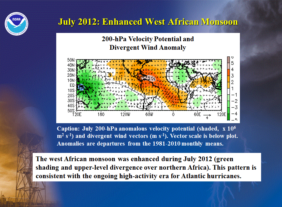
an enhanced west African monsoon. Second, early-season activity in the deep tropics, as seen this
year, is generally indicative of an above-normal season. Finally, although the
most recent CPC/ IRI forecast indicates that El Niño is likely to
form during August or September, its suppressing influence on hurricane activity is not expected until later in the season.
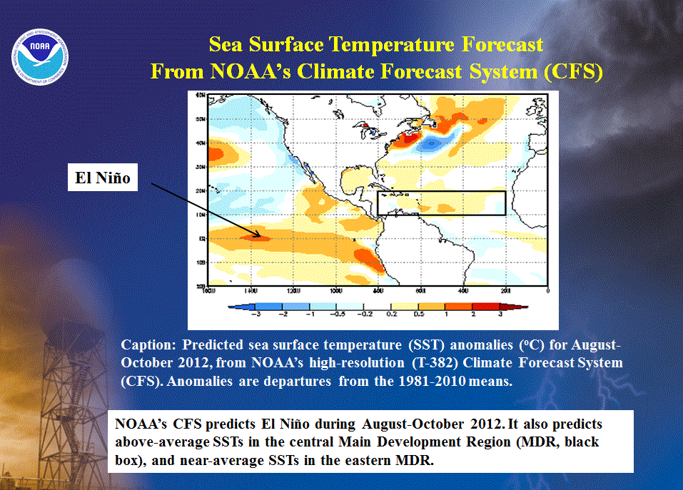
This hurricane outlook also takes into account dynamical model predictions from the NOAA Climate
Forecast System (CFS), NOAA’s Geophysical Fluid Dynamics Lab (GFDL) model CM2.1 and Hi-Ram, the European Centre for Medium
Range Weather Forecasting (ECMWF), the United Kingdom Meteorology (UKMET) office, and the EUROpean Seasonal to Interannual
Prediction (EUROSIP) ensemble.
All of these models predict El Niño for the August-October 2012 season as a whole. For all model
forecasts combined, the seasonal ranges (± 1 σ) of activity are 10.7-14.2 NS, 4.2-7.0 H, 2.5-3.5 MH, and an ACE range of
78.5%-124% of the median. These ranges are centered on 12.5 NS, 5.6 H, and 3.0 MH, and 101% of median ACE, each of which is
near the 1981-2010 seasonal average.
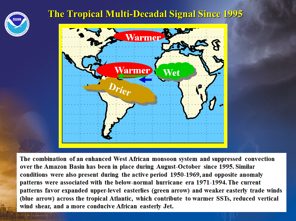
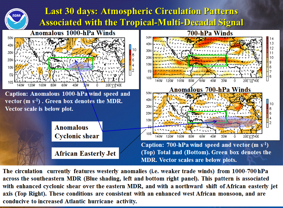
a. Expected continuation of tropical multi-decadal signal
One factor guiding this outlook is the continuation of the tropical multi-decadal signal
(Bell and Chelliah 2006), which has contributed to the current high-activity era in the Atlantic basin that began in 1995.
This signal incorporates the warm phase of the Atlantic Multi-decadal Oscillation (AMO) and an
enhanced west African monsoon system, both of which are now present and are expected to persist
through August-October.
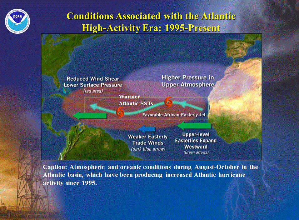
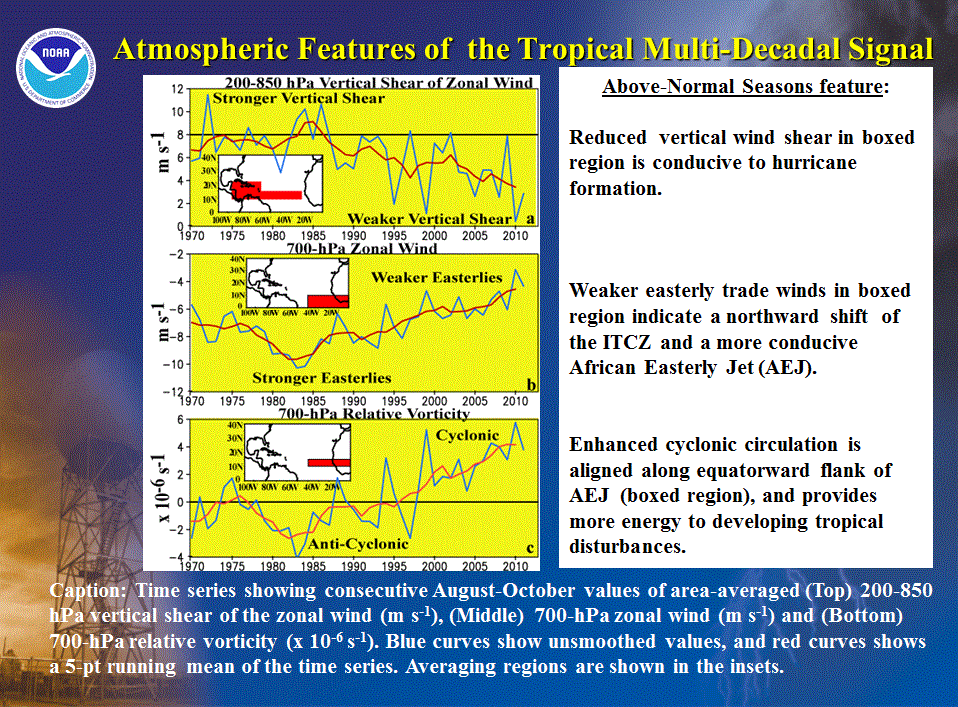
During 1995-2011, key atmospheric features within the MDR have been related to the tropical
multi-decadal signal, including warmer Atlantic temperatures, reduced vertical wind shear, weaker
easterly trade winds, and a stronger mid-to-lower level cyclonic circulation.
Currently, these latter features are very conducive to increased activity in the MDR. They are
associated with a northward shift of the African easterly jet (AEJ) axis, and with a configuration of the AEJ that is more
conducive to hurricane development from African Easterly waves. These waves produce tropical cloud systems that move westward
from Africa, and are responsible for the vast majority of hurricanes and major hurricanes during the peak months
(August-October) of the hurricane season.
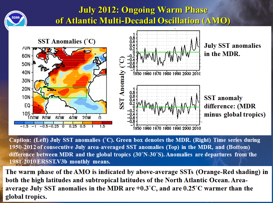
b. Expected above-average SSTs in central Main Development Region
The second factor guiding this outlook is above-average SSTs across the central MDR during August-October, and possibly
near-average SSTs in the far eastern tropical Atlantic. These expectations are based on current observations and
model forecasts.
July SSTs measured over the entire MDR were 0.3oC above average. SSTs were above average across the
western and central MDR, and near-average in the southeastern MDR. The area-averaged SST departure in the MDR was +0.25oC
warmer than that of the global tropics, which is also suggestive of an above-normal season.
However, seasonal Atlantic hurricane activity can also be sensitive to SST departures in the eastern tropical Atlantic, where
easterly waves emerge from the African coast. Near-average SSTs are possible for that region during August-October, and are
typically associated with stronger northeasterly trade winds and less conducive thermodynamics in the northern MDR, both of which
can moderate hurricane activity.
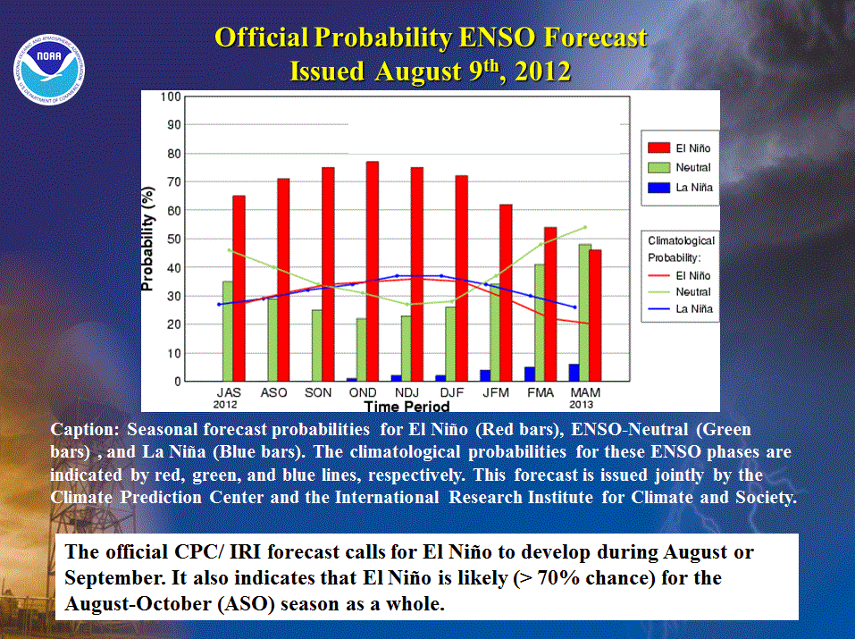
c. El Niño likely, but with impacts delayed until later in the season
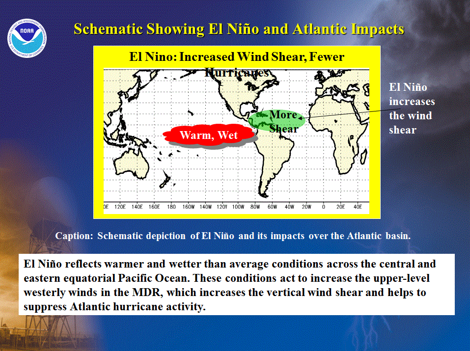
The ENSO (El Niño/Southern Oscillation) is another climate factor known to significantly impact Atlantic hurricane activity.
The three phases of ENSO are El Niño, La Niña, and ENSO-Neutral. El Niño tends to suppress Atlantic
hurricane activity, while La Niña tends to enhance it (Gray 1984). These typical impacts can be strongly modulated by
conditions associated with a low- or high-activity era.
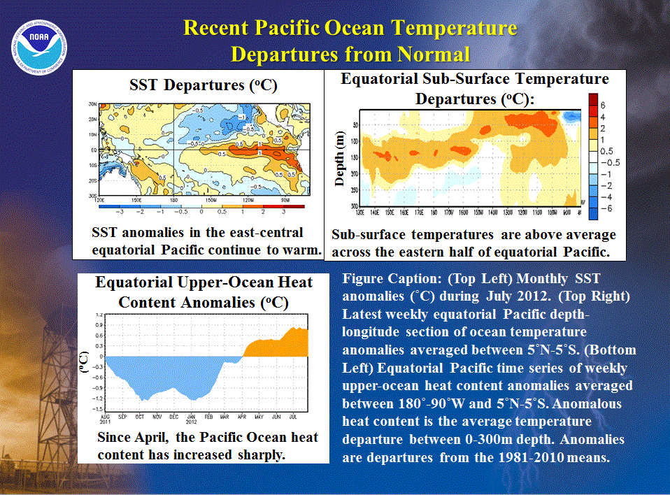
The equatorial Pacific has warmed considerably following the dissipation of La Niña in April. For
July, equatorial SSTs were more than 0.5oC above average east of ~160°W and more than 1.0oC above
average east of ~135oW. The Niño 3.4 index value (used by the CPC to classify ENSO phase and strength), was +0.6
by the last week in July, although El Niño-related circulation anomalies had not yet developed. Pacific sub-surface
temperatures along the equator have also warmed during the last two months, with large areas now recording departures
of 2-4oC. Consistent with this evolution, the oceanic thermocline has become anomalously deep and the equatorial
heat content has increased sharply.
Most dynamical models predict either a weak El Niño (Niño 3.4 SST anomaly range of +0.5oC to +0.9oC)
or moderate El Niño (Niño 3.4 SST anomaly range of +1oC to +1.4oC) for the August-October 2012 period as a whole. Several
statistical models also predict El Niño during this period.
In its latest ENSO Diagnostic Advisory, the CPC/ IRI forecast
indicates that El Niño is likely to form during August or September. That forecast favors the
dynamical model predictions and indicates that once formed, El Niño will likely continue at least into early next year.
However, there remains considerable variability in the predicted strength of El Niño. For example, those dynamical models
which are also used to help predict the seasonal hurricane activity indicate El Niño strengths during August-October ranging
from weak (e.g., CFS high-resolution model) to moderate (CFS low-resolution, V2) to strong (UKMET). Historically, the
combination of a weak El Niño and a high-activity era has been associated with a wide range of seasonal hurricane activity,
from an extremely active season in 2004 to a below-normal season in 2009.
El Niño’s impacts on the vertical wind shear and seasonal hurricane activity not only depend on its
strength, but also on when it forms and on the atmospheric response time once it does form. A slower development of El Niño
and/or a slower atmospheric response time would favor more Atlantic hurricane activity. A faster El Niño development and a
relatively fast atmospheric response would favor less Atlantic hurricane activity.
The timing of El Niño and its impacts is far more confident that was indicated in the May pre-season outlook. That outlook
reflected the possibility that El Niño could form in time to suppress hurricane activity throughout the season’s peak months.
Now, although there is an increased confidence that El Niño will develop during August or September, we are more confident
that its suppressing influence on hurricane activity will be delayed until later in the season.
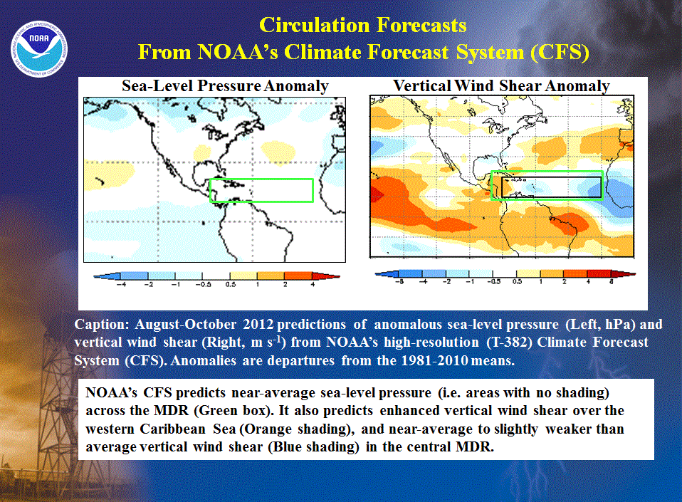
Taking these factors into account, the CFS high-resolution model predicts near-average sea-level
pressure in the MDR during August-October, along with above-average vertical wind shear over the western Caribbean Sea and
near-average vertical wind shear across the central MDR. These conditions are consistent with competing climate factors
(El Niño and the tropical multi-decadal signal), and with that model’s prediction for a near-normal Atlantic hurricane season.
3. Multi-decadal fluctuations in Atlantic hurricane activity
Atlantic hurricane seasons exhibit extended periods lasting decades of generally above-normal or
below-normal activity (high- and low-activity eras, respectively). These fluctuations in hurricane activity result almost
entirely from differences in the number of hurricanes and major hurricanes forming from tropical storms that first develop in
the MDR.
The current high-activity era has been in place since 1995 (Goldenberg et al. 2001). Hurricane seasons during 1995-2011 have
averaged about 15 named storms, 8 hurricanes, and 4 major hurricanes, with an ACE index of 153% of the median. NOAA classifies
12 of the 17 seasons since 1995 as above normal, with eight being extremely active (i.e., hyperactive defined by ACE > 165% of
median). Only five seasons since 1995 have not been above normal, which include the 2007 season and four El Niño years (1997,
2002, 2006, and 2009).
This high level of activity since 1995 contrasts sharply to the low-activity era of 1971-1994, which averaged only 8.5 named
storms, 5 hurricanes, and 1.5 major hurricanes, and had an average ACE index of only 74% of the median. One-half of the
seasons during this low-activity era were below normal, only three were above normal (1980, 1988, 1989), and none were
hyperactive.
Within the MDR, the atmospheric circulation anomalies that contribute to these long-period fluctuations in hurricane activity
are strongly linked to the Tropics-wide multi-decadal signal (Bell and Chelliah 2006), which
incorporates the warm phase of the AMO and an enhanced west African monsoon system. A change in the phase of the tropical
multi-decadal signal coincides with the transition in 1995 from an Atlantic low-activity era to the current Atlantic
high-activity era.
NOAA FORECASTERS
Climate Prediction Center
Dr. Gerry Bell, Lead Forecaster, Meteorologist; Gerry.Bell@noaa.gov
Dr. Jae Schemm, Meteorologist; Jae.Schemm@noaa.gov
National Hurricane Center
Eric Blake, Hurricane Specialist; Eric.S.Blake@noaa.gov
Todd Kimberlain, Hurricane Specialist; Todd Kimberlain@noaa.gov
Dr. Chris Landsea, Meteorologist; Chris.Landsea@noaa.gov
Dr. Richard Pasch, Hurricane Specialist; Richard.J.Pasch@noaa.gov
Hurricane Research Division
Stanley Goldenberg, Meteorologist; Stanley.Goldenberg@noaa.gov
REFERENCES
Bell, G. D., and M. Chelliah, 2006: Leading tropical modes associated with interannual and multi-decadal fluctuations in North Atlantic hurricane activity. J. of Climate. 19, 590-612.
Goldenberg, S. B., C. W. Landsea, A. M. Mestas-Nuñez, and W. M. Gray, 2001: The recent increase in Atlantic hurricane activity: Causes and implications. Science, 293, 474-479.
Gray, W. M., 1984: Atlantic seasonal hurricane frequency: Part I: El Niño and 30-mb quasi-bienniel oscillation influences. Mon. Wea. Rev., 112, 1649-1668.
|


