The 2023 Atlantic Hurricane Season Outlook is an official product of the National Oceanic and Atmospheric Administration (NOAA) Climate Prediction Center (CPC). The outlook is produced in collaboration with hurricane experts from NOAA's National Hurricane Center (NHC) and Atlantic Oceanic and Meteorological Laboratory (AOML). The Atlantic hurricane region includes the North Atlantic Ocean, Caribbean Sea, and Gulf of Mexico.
Interpretation of NOAA's Atlantic hurricane season outlook:
This outlook is a general guide to the expected overall activity during the upcoming hurricane season. It is not a seasonal hurricane landfall forecast, and it does not predict levels of activity for any particular location.
Preparedness:
Hurricane-related disasters can occur whether the season is active or relatively quiet. It only takes one hurricane (or tropical storm) to cause a disaster. It is crucial that residents, businesses, and government agencies of coastal and near-coastal regions prepare for every hurricane season regardless of this, or any other, seasonal outlook. The Federal Emergency Management Agency (FEMA) through www.ready.gov and www.listo.gov, the NHC, the Small Business Administration, and the American Red Cross all provide important hurricane preparedness information on their web sites.
NOAA does not make seasonal hurricane landfall predictions:
NOAA does not make seasonal hurricane landfall predictions. Hurricane landfalls are largely determined by the weather patterns in place as the hurricane approaches, and those patterns are only predictable when the storm is within several days of making landfall.
Nature of this outlook and the "likely" ranges of activity:
This outlook is probabilistic, meaning the stated "likely" ranges of activity have a certain likelihood of occurring. The seasonal activity is expected to fall within these ranges in 7 out of 10 seasons with similar climate conditions and uncertainties to those expected this year. They do not represent the total possible ranges of activity seen in past similar years.
This outlook is based on 1) predictions of large-scale climate factors known to influence seasonal hurricane activity, and 2) climate forecast models that directly predict seasonal hurricane activity. This outlook also takes into account uncertainties inherent in such climate outlooks.
Preparedness for tropical storm and hurricane landfalls:
It only takes one storm hitting an area to cause a disaster, regardless of the overall activity for the season. Therefore, residents, businesses, and government agencies of coastal and near-coastal regions are urged to prepare every hurricane season regardless of this, or any other, seasonal outlook.
Sources of uncertainty in the seasonal outlooks:
-
Predicting El Niño and La Niña events (also called the El Niño-Southern Oscillation, or ENSO) and their impacts on North Atlantic basin hurricane activity, is an ongoing scientific challenge facing scientists today. Such forecasts made during the spring generally have limited skill.
-
Many combinations of named storms, hurricanes and major hurricanes can occur for the same general set of climate conditions. For example, one cannot know with certainty whether a given climate signal will be associated with several shorter-lived storms or fewer longer-lived storms with greater intensity.
-
Model predictions of sea-surface temperatures (SSTs), vertical wind shear, moisture, atmospheric stability, and other factors known to influence overall seasonal hurricane activity have limited skill this far in advance of the peak months (August-October) of the hurricane season.
-
Shorter-term weather patterns that are unpredictable on seasonal time scales can sometimes develop and last for weeks or months, possibly affecting seasonal hurricane activity.
2023 Atlantic Hurricane Season Outlook Summary
a. Predicted Activity
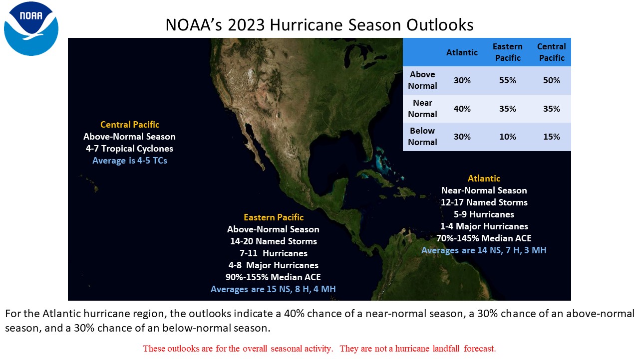
NOAA's outlook for the 2023 Atlantic Hurricane Season indicates that a near-normal season is most likely, with lower but equal possibilities the season could be above- or below-normal. The outlook calls for a 40% chance of a near-normal season, along with a 30% chance for an above-normal and 30% chance for a below-normal season. See NOAA definitions of above-, near-, and below-normal seasons. The Atlantic hurricane region includes the North Atlantic Ocean, Caribbean Sea, and Gulf of Mexico.
The 2023 outlook calls for a 70% probability for each of the following ranges of activity during the 2022 hurricane season, which officially runs from June 1st through November 30th:
- 12-17 Named Storms, which includes the unnamed, short-lived storm in January
- 5-9 Hurricanes
- 1-4 Major Hurricanes
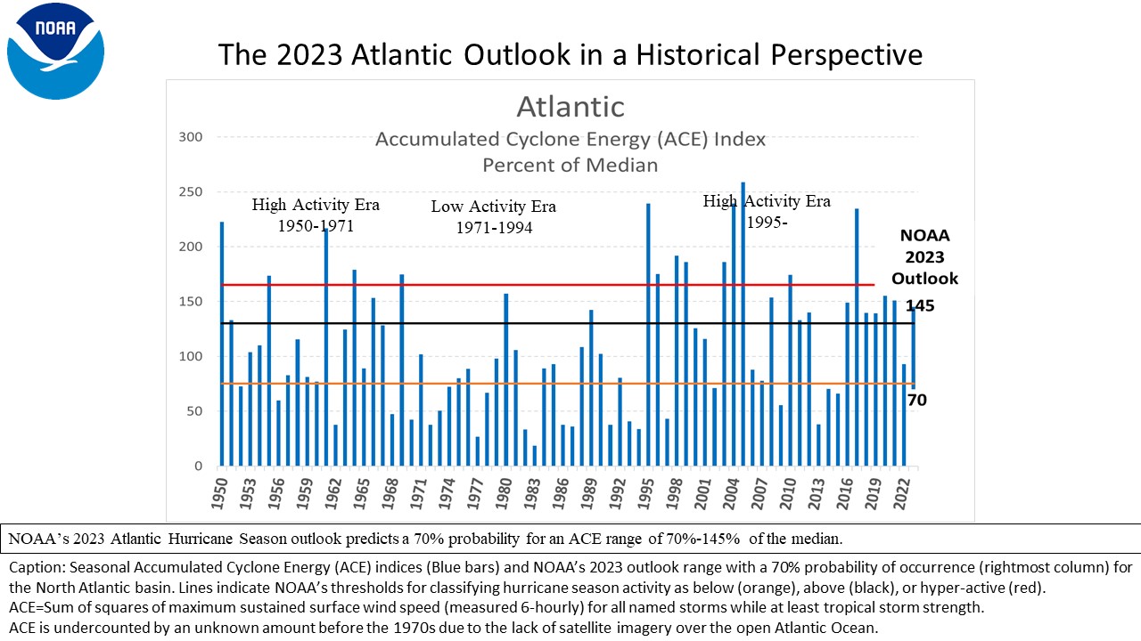
- Accumulated Cyclone Energy (ACE) range of 70%-145% of the median
The seasonal activity is expected to fall within these ranges in 70% of seasons with similar climate conditions and uncertainties to those expected this year. These ranges do not represent the total possible ranges of activity seen in past similar years. These expected ranges are centered near the 1991-2020 seasonal averages of 14 named storms, 7 hurricanes, and 3 major hurricanes. Most of the predicted activity is likely to occur during the peak months (August-October, ASO) of the hurricane season. The predicted range does include the one short-lived subtropical storm that developed in January 2023.
The North Atlantic hurricane season officially runs from June 1st through November 30th. This outlook will be updated in early August to coincide with the onset of the peak months of the season (ASO).
b. Reasoning behind the outlook
This 2023 seasonal hurricane outlook reflects the expectation of either competing or non-reinforcing climate factors during August-October (ASO), and these factors historically produce Atlantic hurricane seasons with a wide range of activity. Seasons with competing large-scale factors often produce seasons with wide ranges of tropical activity. Wide ranges in historical activity when coupled with changing atmospheric responses to El Niño conditions can lead to increased uncertainty in the outlooks. The main climate factors for this outlook are:
-
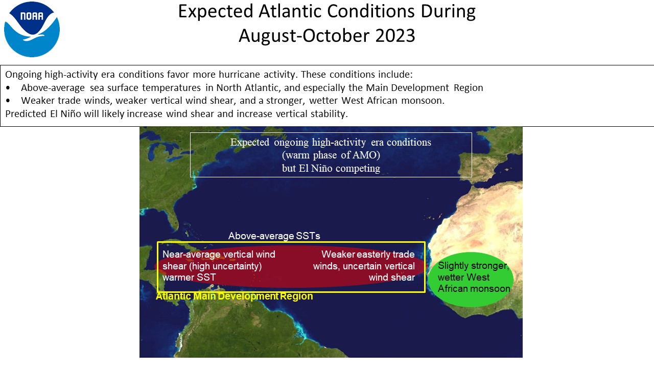
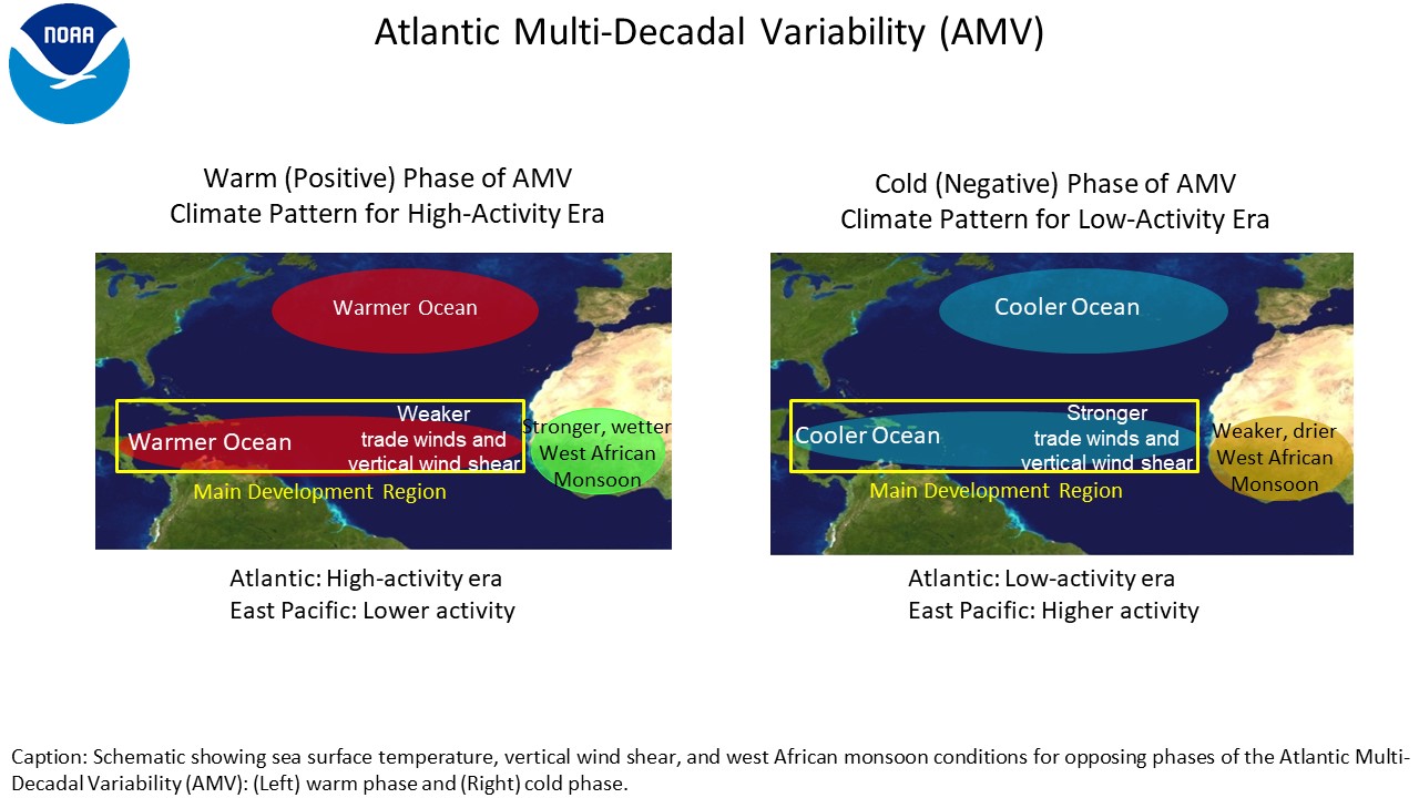
The set of conditions that have produced the ongoing high-activity era for Atlantic hurricanes which began in 1995 are likely to continue in 2023. These conditions include warmer sea-surface temperatures (SSTs) and weaker trade winds in the Atlantic hurricane Main Development Region (MDR), along with weaker vertical wind shear and an enhanced West African monsoon. The oceanic component of these conditions is often referred to as the Atlantic Multidecadal Oscillation (AMO), while the ocean/atmosphere combined system is sometimes referred to as Atlantic Multidecadal Variability (AMV). The MDR spans the tropical North Atlantic Ocean and Caribbean Sea (Goldenberg and Shapiro 1996). Of note, these conditions are not as prominent or amplified at this point in the year as they were in the past 3 seasons (2020, 2021, 2022). SSTs in the MDR are warmer than last year, but the tradewind response is more mixed with weaker winds over the Gulf of Mexico, but stronger tradewinds near the lesser Antilles.
-
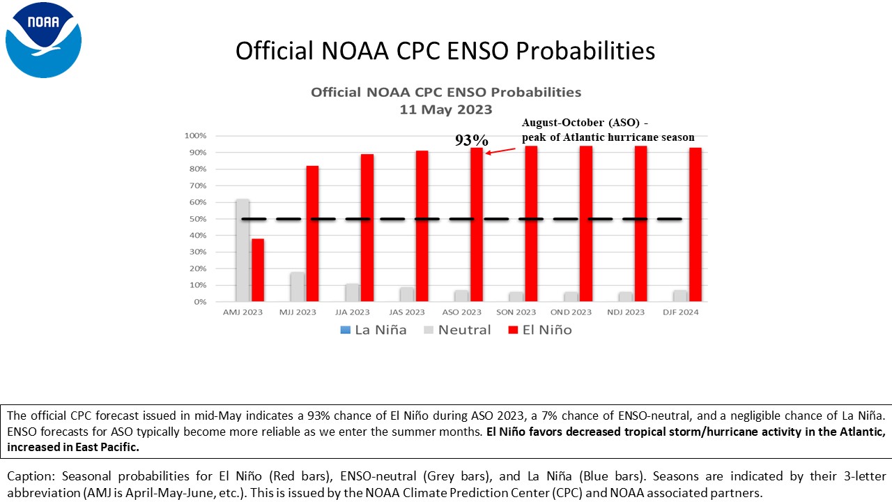
The most recent forecast from the NOAA Climate Prediction Center indicates El Niño conditions are likely through the hurricane season. The odds are highest for El Niño (93%), with a small probability for ENSO-neutral (7%), and a negligible chance of a La Niña event (~0%). During a high-activity era, ENSO-neutral is typically associated with above-average levels of activity. La Niña tends to reinforce those high-activity era conditions and further increases the likelihood of an above-normal season with activity near the upper ends of the predicted ranges. Moderate or strong El Niño events typically have a dampening impact on tropical cyclone activity in the Atlantic basin.
DISCUSSION
1. Expected 2023 activity
NOAA's outlook for the 2023 Atlantic Hurricane Season indicates that a near-normal season is most likely (40% chance). The outlook also includes a 30% chance of an above-normal season, and a 30% chance of a below-normal season.
The 2023 North Atlantic hurricane season is predicted to produce (with 70% probability for each range) 12-17 named storms, of which 5-9 are expected to become hurricanes, and 1-4 of those are expected to become major hurricanes. These ranges are centered near the 1991-2020 period averages of about 14 named storms, 7 hurricanes, and 3 major hurricanes.The 2023 North Atlantic hurricane season could be the second consecutive near-normal season. The last pair of near-normal seasons was 2006 and 2007. Since the current Atlantic high-activity era began in 1995, 19 of 28 (about 68%) seasons have had above-normal activity, and only 5 (18%) and 4 (15%) have had near- and below-normal activity, respectively, based on the 1951-2020 climatology. Also, 9 (almost half) of the above-normal years (thus 32% of the 28 years) have been hyper-active (% median ACE ≥ 165%).
An important measure of the total seasonal activity is NOAA's Accumulated Cyclone Energy (ACE) index, which accounts for the combined intensity and duration of all named storms and hurricanes during the year. This 2023 outlook indicates a 70% chance that the seasonal ACE range will be 70%-145% of the median. According to NOAA's hurricane season classifications, an ACE value between 75.4% and 130% of the 1951-2020 median reflects a near-normal season. Values above (below) this range reflect an above-normal (below-normal) season. The 2023 predicted ACE range is centered on the near-normal range, with small overlaps into the above-normal and below-normal ranges, hence the relatively flat percentages.
Predictions of the location, number, timing, and intensity of hurricane landfalls are ultimately related to the daily weather patterns which determine storm genesis locations and steering patterns. These patterns are not predictable weeks or months in advance. As a result, it is not possible to reliably predict the number or intensity of landfalling hurricanes in a seasonal outlook, or whether a given locality will be impacted by a tropical storm or hurricane this season.
2. Science behind the Outlook
NOAA's North Atlantic Hurricane Season Outlooks are based on predictions of the main climate factors and their associated conditions known to influence seasonal Atlantic hurricane activity. These predictions are based on extensive monitoring, analysis, research activities, a suite of statistical prediction tools, and dynamical models. The dynamical model predictions come from the NOAA Climate Forecast System (CFS), NOAA Geophysical Fluid Dynamics Lab (GFDL) HiFLOR-S and SPEAR-MED models, the North American Multi-Model Ensemble (NMME), the United Kingdom Met Office (UKMET) GloSea6 model, and the European Centre for Medium-Range Weather Forecasting (ECMWF) Seas5 model. ENSO forecasts are also provided from the NMME dynamical models contained in the suite of Niño 3.4 SST forecasts, which is compiled by NOAA's CPC. Newly added this year is a regression model based on the work at AOML. (West et al. 2022).
NOAA's 2023 North Atlantic hurricane season outlook reflects the expectation of competing climate factors during August-October (ASO), as follows:
-
The underlying climate factor again this season is the continuation of the high-activity era for Atlantic hurricanes, which began in 1995 in association with a transition to the warm phase of the Atlantic Multidecadal Oscillation (AMO) (Goldenberg et al. 2001, Bell and Chelliah 2006, Klotzbach and Gray 2008). The recently observed and predicted atmospheric conditions for ASO 2023 reflect the warm AMV phase, and with several factors conducive for higher levels of activity such as weaker trade winds and warmer SSTs across much of the MDR, a more conducive African easterly jet, weaker vertical wind shear, and an enhanced West African monsoon. When the oceanic and atmospheric conditions are considered as a whole, the variability is being more commonly referred to as Atlantic Multidecadal Variability (AMV) in recent literature. The observations and predictions of these values are not as anomalous as in the prior three years (2020, 2021, and 2022). The trade winds over the Atlantic are weaker over the Gulf of Mexico and the northern portions of the MDR, while stronger near the Lesser Antilles. Flow out of the top of the West African Monsoon is not yet well established, but this is likely an impact of intraseasonal oscillations able to move more freely during ENSO-neutral conditions. Predictions of wind shear during 2020-2022 were for almost record low wind shear, while this year, the predictions are closer to normal. Contrasting that are the SSTs which are warmer than last year in much of the Atlantic including the MDR, so a bit counter to some of the atmospheric signals being observed.
-
The most recent NOAA ENSO probability forecast indicates a 93% chance that El Niño conditions will develop through the hurricane season, and a 7% chance that ENSO-neutral conditions could be in place during the peak months (ASO) of the season. Additionally, the ENSO outlook calls for elevated odds of a moderate to strong El Niño this year, though uncertainty at these leads prevents us from delineating between a moderate or a strong El Niño. Strong El Niño conditions were last present in 2015 during ASO, and that year had below-normal activity.
a.El Niño favored
El Niño represents one phase of the climate phenomenon known as ENSO (El Niño-Southern Oscillation). The three phases of ENSO are El Niño, La Niña, and ENSO-neutral. El Niño tends to suppress Atlantic hurricane activity, while La Niña tends to enhance it (Gray 1984; Goldenberg and Shapiro 1996). These impacts can be strongly modulated by conditions associated with a low- or high-activity era, and also by short-lived conditions during any specific year.
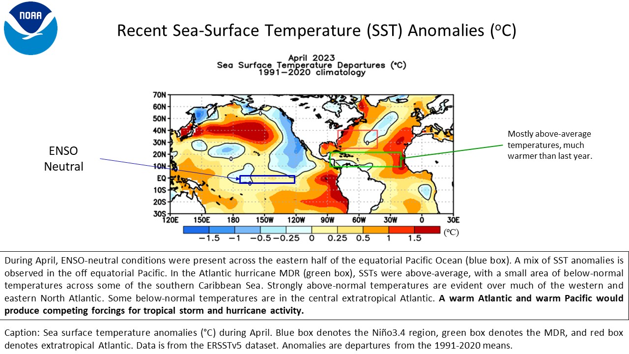
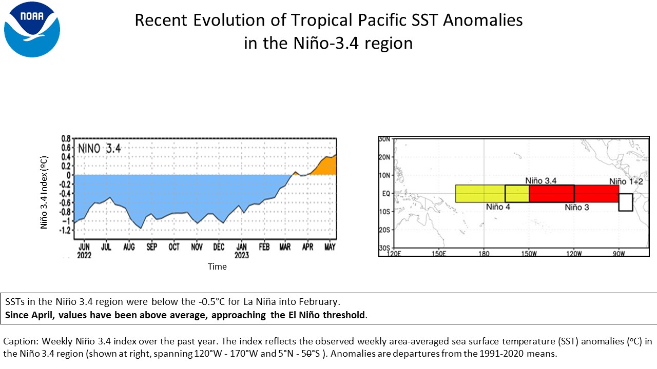
As of May 22, 2023, ENSO-neutral conditions are present. The weekly SSTs are currently slightly above average across much of the central and eastern equatorial Pacific and the SST index for the Niño 3.4 region is +0.5°C. The Niño 3.4 index has shown a significant warming trend since December 2022 and the weekly Niño 3.4 index has increased from -0.5°C in February of 2023 to its current value of +0.5°C. The wind and outgoing longwave radiation patterns over the central Pacific are also reflecting a breakdown of atmospheric response to last year’s La Niña forcings, and are currently showing more influence from intraseasonal modes.
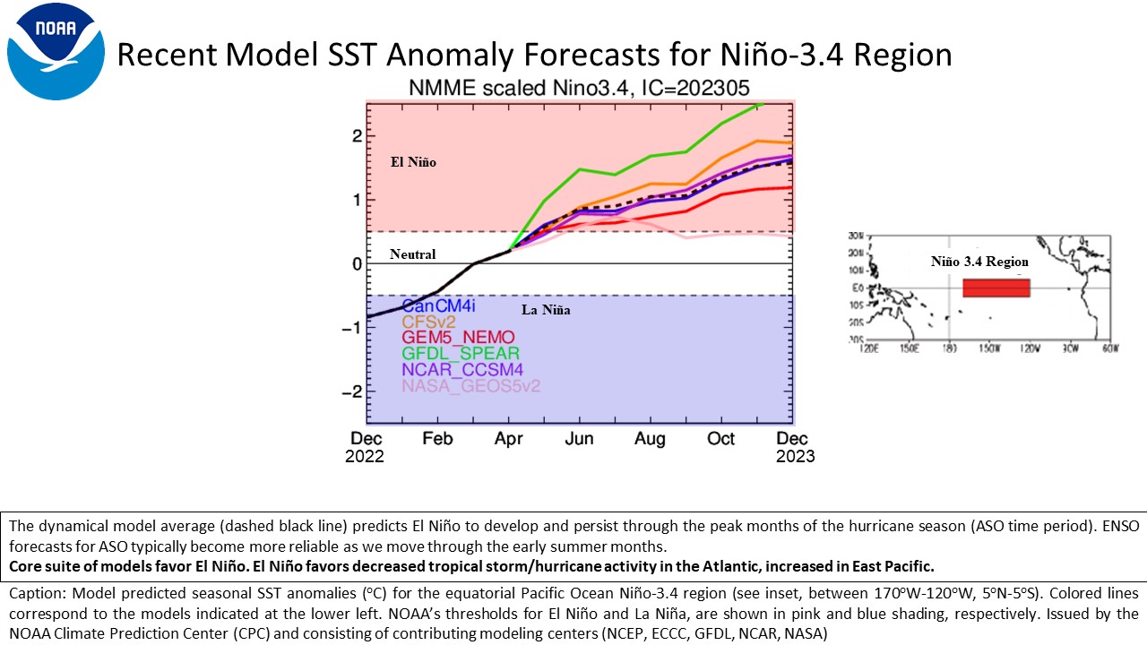
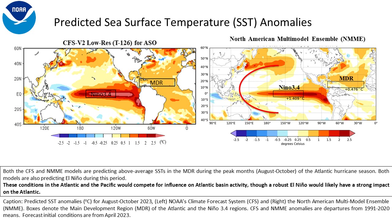
Looking forward, model-predicted SST anomalies in the Niño 3.4 region generally indicate El Niño (Niño 3.4 index greater than +0.5°C) conditions throughout the hurricane season. The dynamical model average (dashed black line) indicates El Niño through the summer and autumn of 2023, with only one modeling system indicating ENSO-neutral conditions, but still showing positive anomalies. When using a larger pool of models that includes multiple dynamical models, multiple statistical models, and unique combinations of those models, 21 of 24 models indicate El Niño conditions, with 3 results not as amplified but still showing positive anomalies.
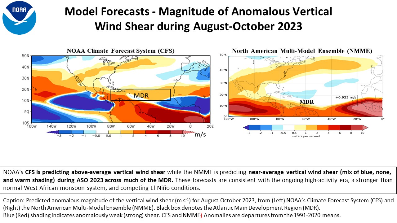
NOAA's Climate Forecast System (CFS) and the North American Multi-model Ensemble (NMME) are predicting El Niño. The CFS predicts above-normal shear over the MDR while the NMME predicts about near-normal shear for the same region. The shear predicted by the NMME this year is closer to climatology than what was predicted last year for much of the Atlantic basin. This is likely associated with the model predictions of El Niño, which is typically associated with near- or above-normal vertical wind shear.
The official NOAA ENSO outlook from May of 2023 indicates about a 93% chance of El Niño during the peak months (ASO) of the hurricane season, only a 7% chance of ENSO-neutral and negligible chance of La Niña. Furthermore, the ENSO team also has indicated a 72% chance of a moderate to strong El Niño event (i.e. ASO Niño 3.4 SST anomaly of +1.0°C or more), making the likelihood of teleconnections to the Atlantic more likely if we reach those higher Niño 3.4 values (L’Heureux et al. 2019). These teleconnections typically increase shear over the MDR thus reducing Atlantic basin hurricane activity. Therefore, the current hurricane season outlook reflects the expectation that the El Niño conditions will compete with, and would likely interfere with, the ongoing set of conditions associated with the current high-activity era for Atlantic hurricanes (discussed below).
b. Predicted conditions within the MDR
SSTs are currently above-average across nearly all of the MDR, with an area-averaged anomaly during April of +0.46°C, compared to only +0.02°C during April last year. For the MDR as a whole, both the CFS and NMME models predict slightly above-average SSTs during ASO. The differences between MDR SSTs and the global tropics is another predictor favoring an above-normal season, and has been linked to some hyper-active years (Blake et al. 2018). Among the NMME models, the predicted values of MDR SST anomalies range from +0.17°C to +0.62°C, with the multi-model, spatial average being +0.48°C. The outlook for SSTs in the MDR is warmer than last year’s prediction, but this year the difference in the MDR from the global tropics is about the same as 2022. However, most models tend to have only modest skill in predicting the strength of the Atlantic SST anomalies this far in advance, though these model predictions are consistent with the ongoing warm phase of the AMV. SSTs across the North Atlantic basin are presently above-normal and predicted to stay above-normal at least through ASO.
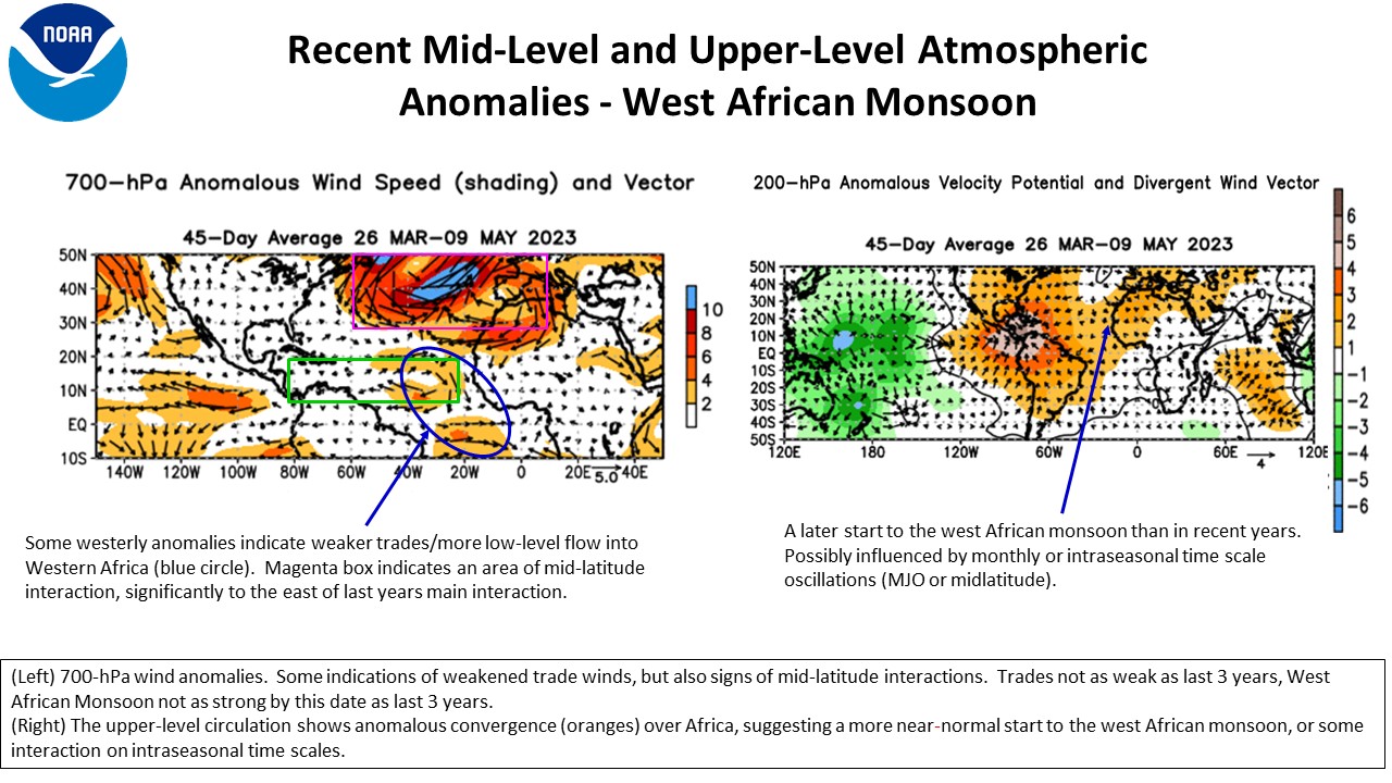
Two inter-related atmospheric features, also related to the warm phase of the AMO/AMV that are typically analyzed, are anomalous winds at 700-hPa across the central and eastern tropical Atlantic and the strength of the West African monsoon system. The 700-hPa winds show a weak anticyclonic circulation, which would be indicative of weaker trade winds. The outflow at the top of the West African Monsoon, as analyzed by 200-hPa Velocity Potential Anomaly and divergent wind is showing a weaker than normal circulation. The Madden-Julian Oscillation (MJO) may have played a role in some early suppression of upper-level divergence and rainfall totals, so if the MJO continues to propagate eastward, some more favorable circulations would likely develop. If the monsoon stays enhanced as indicated in many of the model outlooks, these conditions are expected to contribute to an interrelated set of conditions during ASO within the MDR, all of which favor increased Atlantic hurricane activity. These interrelated features include 1) anomalously warm SSTs and decreased vertical wind shear, 2) an African Easterly Jet structure that allows for increased rotation of low-pressure cloud systems (aka African easterly waves) moving westward from Africa, and 3) the combination of increased moisture and decreased atmospheric stability. Because of these conditions, the enhanced African easterly waves can develop more easily into tropical storms and hurricanes, thus creating a forcing that would be in opposition to those expected and associated with El Niño, increasing the uncertainty in the outlook and supporting a forecast for near-normal activity this season rather than below-normal typically associated with El Niño.
c. Factors increasing the uncertainty
The main uncertainty in this seasonal hurricane outlook is the interplay between the predicted El Niño which favors lower activity and the predicted set of conditions in the MDR that are conducive to more activity. So even though El Niño conditions will probably develop in the Pacific and create the traditional teleconnection patterns associated with lower tropical storm and hurricane activity in the Atlantic Basin, the local (MDR) conditions could be strong enough to dominate and thus allow high-activity era conditions to rule, resulting in a season near the upper end of our forecast range. SSTs in the MDR are much warmer, relative to normal, but exhibit a different spatial structure than at this same point last year, suggesting there are differences in the overlying atmospheric circulation patterns. This suggests that the change from La Niña to El Niño already being felt in the MDR In addition, the NMME model-predicted shear values are in the near normal range, suggesting some local feedback to counteract the traditional El Niño influence, so that interplay creates a heightened amount of uncertainty for this outlook. The impact of combination of these various climate factors should be much more clear by the time of the August update of this outlook.
NOAA FORECASTERS
Climate Prediction Center
- Matt Rosencrans, Physical Scientist; Matthew.Rosencrans{at}noaa.gov
- Dr. Hui Wang, Physical Scientist; Hui.Wang{at}noaa.gov
- Dr. Daniel Harnos, Meteorologist; Daniel.Harnos{at}noaa.gov
National Hurricane Center
- Eric Blake, Senior Hurricane Specialist; Eric.S.Blake{at}noaa.gov
- Dr. Chris Landsea, Branch Chief; Chris.Landsea{at}noaa.gov
- Dr. Richard Pasch, Senior Hurricane Specialist; Richard.J.Pasch{at}noaa.gov
Atlantic Oceanographic and Meteorological Laboratory
- Stanley Goldenberg, Meteorologist; Stanley.Goldenberg{at}noaa.gov
- Dr. Hosmay Lopez, Oceanographer; Hosmay.Lopez{at}noaa.gov
REFERENCES
Bell, G. D., and M. Chelliah, 2006: Leading tropical modes associated with interannual and multi-decadal fluctuations in North Atlantic hurricane activity. J. Climate, 19, 590-612. Blake, E. S., P. Klotzbach, and G. D. Bell, 2018: Climate factors causing the extremely active 2017 Atlantic hurricane season. Presented at AMS 33rd Conference on Hurricanes and Tropical Meteorology, April 2018. Goldenberg, S. B., C. W. Landsea, A. M. Mestas-Nuñez, and W. M. Gray, 2001: The recent increase in Atlantic hurricane activity: Causes and implications. Science, 293, 474-479. Goldenberg, S. B. and L. J. Shapiro, 1996: Physical mechanisms for the association of El Niño and West African rainfall with Atlantic major hurricane activity. J. Climate, 9, 1169-1187. Gray, W. M., 1984: Atlantic seasonal hurricane frequency: Part I: El Niño and 30-mb quasi-bienniel oscillation influences. Mon. Wea. Rev., 112, 1649-1668. Klotzbach, P.J., and W. M. Gray, 2008: Multi-decadal Variability in North Atlantic Tropical Cyclone Activity. J. Climate, 21, 3929 - 3935. L’Heureux, M. L., and Coauthors, 2019: Strength Outlooks for the El NiñoSouthern Oscillation. Wea. Forecasting, 34, 165175, https://doi.org/10.1175/WAF-D-18-0126.1. West, R., Lopez, H., Lee, S. K., Mercer, A. E., Kim, D., Foltz, G. R., & Balaguru, K. (2022). Seasonality of interbasin SST contributions to Atlantic tropical cyclone activity. Geophysical Research Letters, 49(4), e2021GL096712.
|


