[Previous Article] [Next Article]
Canonical correlation analysis (CCA) is used here to predict the SST adjacent to the U.S. coast around Hawaii,
the mainland West Coast, the Gulf of Mexico coast and the Southeast Coast. Coastal SST forecasts are provided for
commercial fishing interests as well as tourists (e.g. bathers and surfers). As described in several other articles in this
Bulletin, CCA identifies linear relationships between multicomponent predictors and multicomponent predictands. In
the present application, fields of near-global SST, Northern Hemisphere 700 mb height and the coastal SST predictand
itself are used as predictors, covering four consecutive 3-month periods ending at the time of the forecast. To prevent
overfitting in the weaker predictors, the SST field is weighted double on entry to the analysis, following standardization.
The predictand is the coastal SST at various 3-month periods following the time of the forecast, ranging from zero lead
(beginning at forecast time) out to a year ahead. The predictand SST is presented in 2o x 2 o boxes, using COADS data
from 1955 to 1979 and optimum interpolation data from 1990 to the present. The predictor and predictand data are
filtered separately using standard EOF analyses prior to the CCA, as done originally by Barnett and Preisendorfer (1987)
and in subsequent applications such as Graham et al. (1987a,b), Barnston and Ropelewski (1992), Barnston (1994),
He and Barnston (1996), Shabbar and Barnston (1996) and Johansson et. al (1997).
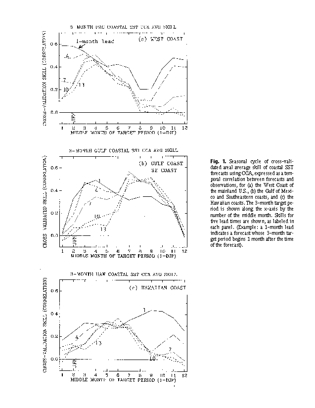
The expected skill of the forecasts was estimated using cross-validation, in which each year in turn was held out
of the model development sample and used as the forecast target. Figure 1 shows the seasonal cycle of areal average
skill of the SST forecasts (temporal correlation between forecasts and observations), for (a) the West Coast of the
mainland U.S., (b) the Gulf of Mexico and Southeastern coasts, and (c) the Hawaiian coasts. The 3-month target period
is shown on the horizontal axis by the middle month number. Skills for five lead times are shown, as labeled in months.
A 1-month lead indicates a forecast whose 3-month target period begins 1 month after the time of the forecast. Moderate
skills are found for the SST along the West Coast for the cold half of the year for leads of up to 4 months, and for the
Gulf/Southeast coasts for all seasons except winter at short leads and for late summer/early fall at both short and long
leads. In the Hawaiian region skills are relatively lower. CCA skills are higher than the skill of persistence forecasts
(with respect to the fourth of the four predictor periods), except for the Hawaiian skills for 1-month lead which are
actually lower than persistence skills in the fall.
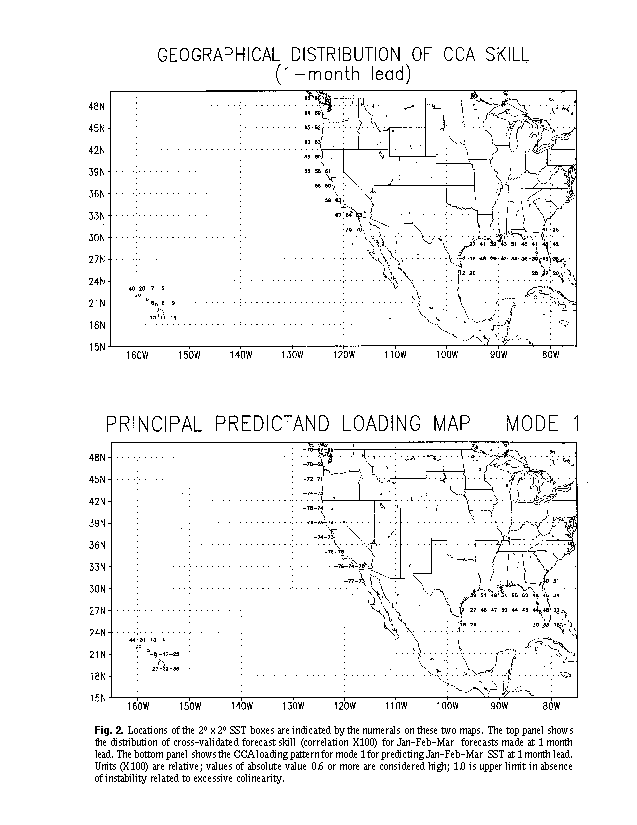
The top panel of Fig. 2 shows the geographical distribution of skill for Jan-Feb-Mar forecasts at 1 month lead. Skill
is moderately high along the west U.S. coast, modest in the eastern Gulf of Mexico and along the east coast of Florida,
and low around most of Hawaii. The bottom panel shows the loading pattern of the predictand for CCA mode 1 for this
same forecast. The predictor loading pattern for this mode (not shown) clearly indicates the development of a cold
ENSO episode during the summer and fall of the previous year. The predictand pattern shows that the SST anomalies
associated with a cold ENSO Jan-Feb-Mar: negative anomalies along the West Coast, positive anomalies in the Gulf
of Mexico and Southeast Coast, and negative (positive) anomalies in southern (northern) Hawaii. The fact that Hawaii
lies in a south-north transition zone with respect to ENSO-related anomalies leads to lower predictive skill there, since
it cannot benefit greatly from knowledge about the likely ENSO state as can many of the other coastal regions examined
here.
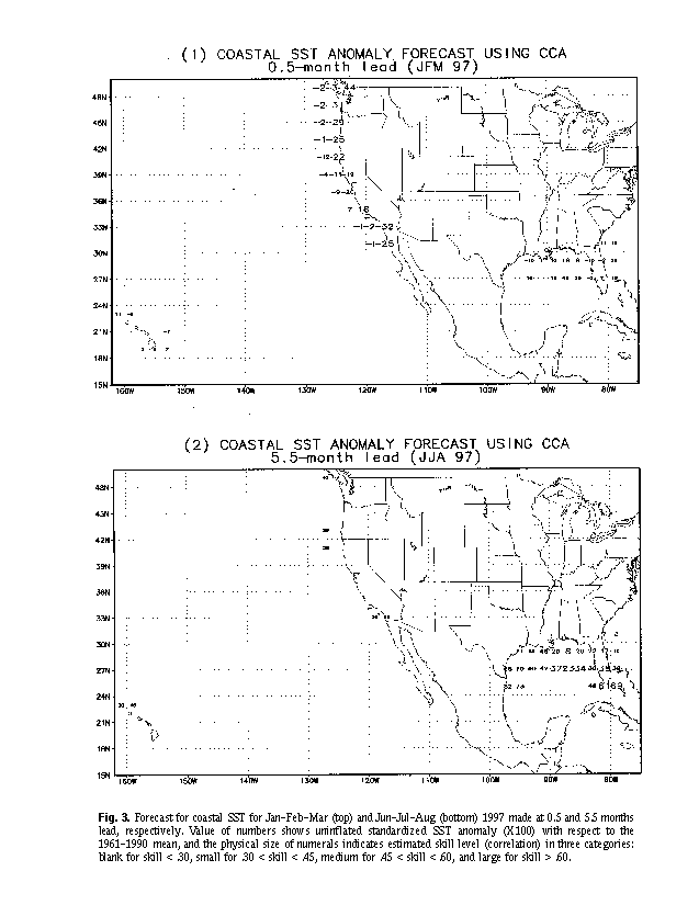
Figure 3 shows the coastal SST forecasts for Jan-Feb-Mar (top) and Jun-Jul-Aug (bottom) of 1997, made in mid-December 1996. For Jan-Feb-Mar weak negative anomalies are forecast for the West Coast of the U.S. with moderate
skill. Negative anomalies in this region are already in place in mid-December, and are related to the cool ENSO episode
throughout 1966. In the Gulf of Mexico, the Southeast Coast and Hawaii, mainly weak anomalies are forecast with low
skill. The forecast for Jun-Jul-Aug features warmth in the Gulf of Mexico with highest skill in the eastern Gulf and near
southern Florida. With lower skill, positive anomalies are also suggested in portions of the West Coast and northern
Hawaii.
Barnett, T.P. and R. Preisendorfer, 1987: Origins and levels of monthly and seasonal forecast skill for United
States surface air temperatures determined by canonical correlation analysis. Mon. Wea. Rev., 115, 1825-1850.
Barnston, A.G., 1994: Linear statistical short-term climate predictive skill in the Northern Hemisphere. J. Climate,
7, 1513-1564.
Barnston, A.G. and C.F. Ropelewski, 1992: Prediction of ENSO episodes using canonical correlation analysis.
J. Climate, 5, 1316-1345.
Barnston, A.G. and Y. He, 1996: Skill of CCA forecasts of 3-month mean surface climate in Hawaii and Alaska.
J. Climate, 9, 2579-2605.
Graham, N.E., J. Michaelsen and T. Barnett, 1987a: An investigation of the El Niño-Southern Oscillation cycle
with statistical models. 1. Predictor field characteristics. J. Geophys. Res., 92, 14251-14270.
Graham, N.E., J. Machaelsen and T. Barnett, 1987b: An investigation of the El Niño-Southern Oscillation cycle
with statistical models. 2. Model results. J. Geophys. Res., 92, 14271-14289.
He, Y. and A.G. Barnston, 1996: Long-lead forecasts of seasonal precipitation in the tropical Pacific islands Using
CCA. J. Climate, 9, 2020-2035.
Johansson, Å., A.G. Barnston, S. Saha and H.M. van den Dool, 1997: The level and origin of seasonal forecast
skill in northern Europe. J. Atmos. Sci., 54, accepted.
Shabbar, A. and A.G. Barnston, 1996: Skill of seasonal climate forecasts in Canada using canonical correlation
analysis. Mon. Wea. Rev., 124, 2370-2385.
Fig. 1. Seasonal cycle of cross-validated areal average skill of coastal SST forecasts using CCA, expressed as a
temporal correlation between forecasts and observations, for (a) the West Coast of the mainland U.S., (b) the Gulf of
Mexico and Southeastern coasts, and (c) the Hawaiian coasts. The 3-month target period is shown along the x-axis by
the number of the middle month. Skills for five lead times are shown, as labeled in each panel. (Example: a 1-month
lead indicates a forecast whose 3-month target period begins 1 month after the time of the forecast).
Fig. 2. Locations of the 2o x 2o SST boxes are indicated by the numerals on these two maps. The top panel shows
the distribution of cross-validated forecast skill (correlation X100) for Jan-Feb-Mar forecasts made at 1 month lead. The
bottom panel shows the CCA loading pattern for mode 1 for predicting Jan-Feb-Mar SST at 1 month lead. Units (X100)
are relative; values of absolute value 0.6 or more are considered high; 1.0 is upper limit in absence of instability related
to excessive colinearity.
Fig. 3. Forecast for coastal SST for Jan-Feb-Mar (top) and Jun-Jul-Aug (bottom) 1997 made at 0.5 and 5.5 months
lead, respectively. Value of numbers shows uninflated standardized SST anomaly (X100) with respect to the 1961-1990
mean, and the physical size of numerals indicates estimated skill level (correlation) in three categories: blank for skill
< .30, small for .30 < skill < .45, medium for .45 < skill < .60, and large for skill > .60.