[Previous Article] [Next Article]
Prediction of Precipitation in Northeast Brazil for Boreal Spring 1997
Using an Atmospheric GCM with Persisted SST Anomalies
contributed by Nicholas Graham
Scripps Institution of Oceanography, La Jolla, California
Interannual rainfall variability has long been a concern to agricultural and water management
interests in northeastern Brazil. The Nordeste is climatologically dry much of the year, with
significant rainfall concentrated mainly in February, March and April. Some of the interannual
variance of this rainfall has been found to be predictable using statistical methods (Hastenrath and
Greischar 1993, Ward and Folland 1991; the forecasts of which are shown in the Greischar and
Colman sections of this issue, respectively). Here we predict this rainfall using a dynamical
approach.
Since 1993, forecasts of precipitation in northeastern Brazil have been prepared using a general
circulation model forced with persisted or model-forecast SST anomalies from the beginning of
the Feb-Mar-Apr-May wet season. The forecasts are made using the Max-Planck Institute for
Meteorology (MPI)/University of Hamburg ECHAM3.2 atmospheric GCM, configured with T42
truncation (giving a physical grid resolution of approximately 2.5 degrees) and 19 vertical layers.
The forecasts of most value to planners in northeastern Brazil are those produced in early January,
early February and early March.
Figure 14 of the March 1994 issue of this Bulletin shows the spatial distribution of estimated
correlation skill in predicting South American precipitation from near-simultaneous SST for
boreal spring (Mar-Apr-May) over the 1970-93 period. Skill maxima were found on the west
coast of equatorial South America and in northeast Brazil, with the latter value 0.69. Still higher
skills are produced when only the wettest and driest years are forecast (Graham 1994). Skill
would be somewhat lower for persisted previous SST rather than near-simultaneous SST. On the
other hand, the ECHAM3 model was used in 1994; an improved ECHAM3.2 version is now
used. An updated estimate of skill is given below with the forecast presentation.
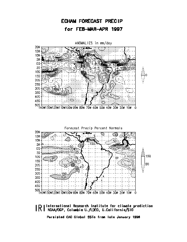
Figure 1 shows the predicted rainfall in South America and surrounding oceans as an anomaly
(top) and as a percent of normal precipitation (bottom) for Feb-Mar-Apr 1997. Persisted global
SST anomalies for the last week of January 1996 are used as boundary forcing (added to the
climatologies for the respective months) for the ECHAM3.2 atmospheric GCM. While this is a
zero-lead forecast, the integrations extend several months into the future. An ensemble of 6
simulations was used, covering January through April, each member using different atmospheric
initial conditions (chosen at random from restart files for the same time of year). Evaluation of the
results from retrospective forecasts over the period 1970-91 (in this case with ensembles of 3
simulations each year) using this approach resulted in correlations of up to 0.4 to 0.6 for the
individual grid squares over the central portion of the Nordeste region of Brazil and north of the
Amazon. Elsewhere, correlation skills typically range from 0 to 0.4. The forecast map depicts
dry (40 to 75% of normal) conditions over the Nordeste, with wetter than normal conditions
to the north at the equator and to the south at 10-20S. A forecast using the NCEP coupled model
(not shown) produced a similar precipitation pattern for this period. This pattern is consistent with
the current SST anomaly patterns in the tropical Atlantic: There are more positive SST anomalies
in the north tropical Atlantic, especially near the African coast, than in the south and
near-equatorial tropical Atlantic--a pattern that is statistically not favorable for Nordeste
precipitation. While cool SSTs in the tropical central and eastern Pacific are associated with
wetter than normal conditions in the Nordeste, the negative Pacific anomalies have been
weakening and may become neutral or even slightly warm by the end of the April 1997.
Forecasts such as these have proven useful to regional agencies (e.g. FUNCEME in the state of
Ceara) responsible for managing water resources and providing guidance on crop selection and
planting. For example, based on a forecast of continued severe drought in 1993, construction of
hydrologic facilities was instituted that prevented water shortages later in the year. In 1994, a
forecast of normal to slightly wetter than normal conditions allowed agricultural managers to
devise a planting strategy that resulted in record agricultural production in the state of Ceara.
Ward, M.N. and C.K. Folland, 1991: Prediction of seasonal rainfall in the North Nordeste of Brazil using eigenvectors of sea surface temperature. Int. J. Climatol., 11, 711-743.
Hastenrath, S. and L. Greischar, 1993: Further work on the prediction of northeast Brazil rainfall
anomalies. J. Climate, 6, 743-758.
Graham, N.E., 1994: Experimental predictions of wet season precipitation in northeastern Brazil.
Proceedings of the 18th Annual Climate Diagnostics Workshop, Boulder, Colorado, November
1-5, 1993, 378-381.
Fig. 1. Precipitation forecast for Feb-Mar-Apr 1997 using the ECHAM3.2 atmospheric GCM
with persisted global SST anomalies from the last week of January 1997. Top: actual precipitation
anomalies; bottom: percentage of normal.