A Dynamical One-Month Lead Seasonal Rainfall Prediction for
March to May 1997 for the North-eastern Area of South America
contributed by Mike Harrison1, Tony Evans1,
Ruth Evans1, Mike Davey2, and Andrew Colman2
1NWP Division 2Ocean Applications Branch
UK Meteorological Office, Bracknell, United Kingdom
One objective of the European PROVOST experiment (PRediction Of climate
Variations On Seasonal and interannual Timescales) is to estimate potential
dynamical seasonal predictability given ideal surface boundary conditions
on a global scale. To this end, four European models (the UKMO Unified
Model at climate resolution, the ECMWF T63 model and the ARPEGE model run
at T42 by Mätäo-France and T63 by EDF) have been integrated in
9-member ensembles initialized at 24-hour intervals for four months for
each season over 15 years from 1979 to 1993 (climatologies are calculated
over the same period). Common initial conditions and verifying analyses
obtained from the ECMWF reanalysis as well as common SST anomalies from
the UKMO GISST and Reynold's OI data sets were used in all experiments.
All initializations were at 0000Z finishing on the day prior to the start
of the season. The north-eastern region of South America has been identified
through these PROVOST experiments using the UKMO model as an area of relatively
high predictability and in this paper a real-time seasonal forecast at
one month lead is provided for the region based on these assessments.
The area with higher predictability broadly stretches through much of
eastern Brazil, the Amazon Basin, French Guiana, Surinam and Guyana, even
covering the southeastern parts of the Caribbean. Within this area correlations
over the 15 years between ensemble-mean rainfall anomalies and anomaly
values obtained from the gridded observed land-surface rainfall data set
of Hulme (1994) exceed 0.5, with correlations in excess of 0.8 in the vicinity
of the Nordeste region of Brazil (Fig. 1). The observed data set is gridded
to the same resolution as the model (2.5° x 3.75°), but in order
to reduce noise 4° x 4° blocks have been joined together to produce
Figure 1; only blocks with adequate data were retained. Time series of
en-semble mean rainfall and the Hulme data for selected regions illustrate
the fact that the dynamical model, although able to capture the interannual
variability reasonably well, has insufficient variability (Fig. 2). Hence
a variance inflation has been calculated using en-semble means for each
gridded area and applied to the forecasts from both the members and the
ensemble means given below. Also shown in Figure 2 are correlations between
ensemble mean predictions and some of the common rainfall indices for the
Nordeste (see Colman et al. 1997 for index details); again the model has
a high level of predictability (correlations approach 0.9) but requires
variance inflation (here done against the FQ index, but results for other
indices are almost identical). Note that observed anomalies frequently
lie within the ranges of the inflated ensembles or are close outliers to
those ranges.
Forecasts as produced for the 1997 March to May season are derived from
nine-member ensemble runs, but with two major design differences from the
predictability experiments outlined above. First, initialization for the
predictions is from late January rather than late February as in the PROVOST
runs. Secondly, the real-time experiments use persisted SST anomalies (from
January) throughout. Neither is thought likely to have significant negative
impacts on the model's ability to provide real-time predictions. Skill
over the region as deduced from the PROVOST runs remains high throughout
the year, whether for months 1 to 3 or 2 to 4 of the simulations. Indeed,
equivalent levels of skill tend to be present on a monthly time scale,
although with some drop-off into the fourth month. Hence the shift in the
start date is considered highly unlikely to affect potential predictability
for the region from that deduced for the "standard" seasons.
Concerning use of persisted SST anomalies, experiments for six winter seasons
have been carried out to date with persisted SST anomalies. While there
is some inevitable loss of predictability associated with the use of persisted
anomalies, this appears to be minimal in areas of relatively high predictability
such as considered here, and certainly does not eliminate predictability
in terms of the levels normally associated with seasonal forecasts (Fig.
3). Use of persisted anomalies fails, of course, during seasons in which
there is a substantial readjustment of SST anomalies over ocean areas related
to a given region's rainfall; experience has been gained of such failed
forecasts for the Nordeste in preliminary work with the model. Currently
there is no solution to this problem of rapid intraseasonal SST anomaly
distribution changes: the forecasts given below are conditional on the
assumption of continuity of the January anomalies.
The ensemble provides a consistent prediction of above-average rainfall
during March to May 1997 across the region except over the continental
interior (area E - below average in all members) and over the Nordeste
(area D), where five members are below-average (Fig. 4 and Table 1). A
southward displacement of the ITCZ from its model climatological location
is suggested. Inflated ensemble-mean, together with maximum and minimum,
rainfall anomalies for each of the gridded areas depicted in Fig. 1, plus
for various Nordeste rainfall indices, are listed in Table 1. Note that
the gridded prediction for the Nordeste is somewhat less than for the indices,
mainly because the block includes signal from the oceanic dry area representing
the shift in ITCZ location (Fig. 4).
For the first time since this research began, the dynamical model forecasts
for the Nordeste rainfall indices are entirely inconsistent with those
from the empirical techniques developed at UKMO (Colman et al. 1997; this
issue), techniques with an extended history of high skill. Examination
of the empirical methods indicates that most of the information this season
is being extracted from the Atlantic dipole, with a sign associated with
dry Nordeste conditions. An ENSO predictor is also included in the empirical
model, but this is currently weak. Scrutiny of Atlantic SST anomalies in
January 1997 reveals a region of warm anomalies extending eastward from
the Nordeste/Bahia coastal regions. Brief analysis suggests that anomalies
of this sign in this region are typically associated with above-average
Nordeste rainfall. It is hypothesized, therefore, that the difference in
the empirical and dynamical predictions may result from the dynamical model's
ability to respond to SST anomalies off Bahia whereas the UKMO empirical
methods are tuned only to basin-scale anomalies and hence do not give much
weight to the relatively localized effects from the Bahia region.
Colman, et al., 1997: Multiple regression and discriminant analysis
predictions of Mar-Apr-May 1997 rainfall in northeast Brazil. Experimental
Long-Lead Forecast Bulletin, Vol. 6, No. 1 (this issue).
Hulme, M., 1994: Validation of large-scale precipitation fields in general
circulation models. Global Precipitation and Climate Change, M.
Desbois and F. Desalmand, Eds., NATO ASI Series, Vol. 23, Springer-Verlag,
387-406.
Table 1. March to May 1997 seasonal forecast rainfall percentages of
normal for the unmodified Ensemble Mean (E Mean - with respect to the model
1979-1993 climate) and inflated Mean (I Mean - with respect to the Hulme
data for 1979-1983) and for the highest and lowest (inflated) ensemble
members for each of the 6 areas depicted in Figure 1. Also shown are equivalent
predictions for three Nordeste rainfall indices (FQ - Fortaleza-Quixeramobim;
N -Nobre; H - Hastenrath; see Colman et al., 1997), inflated using the
FQ index, estimated from the closest two and four model grid points; the
equivalent Hulme area is D. Note that the rainfall indices refer to different
periods although all have been predicted using March to May model rainfall
(FQ - March-May; Nobre - February-May; Hastenrath - March-April); thus
the Nobre prediction is not at long lead.
| Forecast | A | B | C | D | E | F | 2 Grid Points | 4 Grid Points | ||||||||
| (%) | FQ | N | H | FQ | N | H | ||||||||||
| E Mean | 172 | 224 | 121 | 101 | 87 | 142 | 121 | 121 | 121 | 138 | 138 | 138 | ||||
| I Mean | 299 | 377 | 146 | 103 | 57 | 198 | 146 | 145 | 145 | 166 | 149 | 153 | ||||
| I Highest | 344 | 429 | 215 | 118 | 99 | 273 | 164 | 160 | 164 | 188 | 178 | 183 | ||||
| I Lowest | 188 | 324 | 138 | 85 | 23 | 126 | 130 | 128 | 130 | 134 | 127 | 131 | ||||
Fig. 1. Correlations for hindcasts over March
to May 1979-93 between ensemble mean rainfall and the Hulme gridded rainfall
set over 10 x 15 degree blocks.
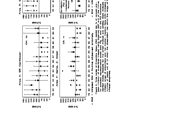
Fig. 2. Time series of Ensemble Mean (EM) rainfall
(as % of normal) pre- and post-inflation of ensembles created using observed
SST and of the Hulme dataset for selected representative areas (see Fig.
1) and for the FQ Nordeste rainfall index. Results for the other indices
are similar. Bars indicate inflated range of ensembles and the median.
Capture Rate (CR) indicates the number of years out of 15 when the observations
lies within the range of the inflated ensemble.
Fig. 3. Ensemble mean January to March one
month lead hindcasts as % of normal for Area D (Fig. 1) for ensembles using
observed and persisted SSTs from 1989 to 1994. Correlation between observed
and persisted SST hindcasts is 0.78. Results for the other regions and
the Nordeste indices are similar. Symbols: circle-observed SSTs; triangle-persisted
SSTs; square-Hulme observed anomaly.