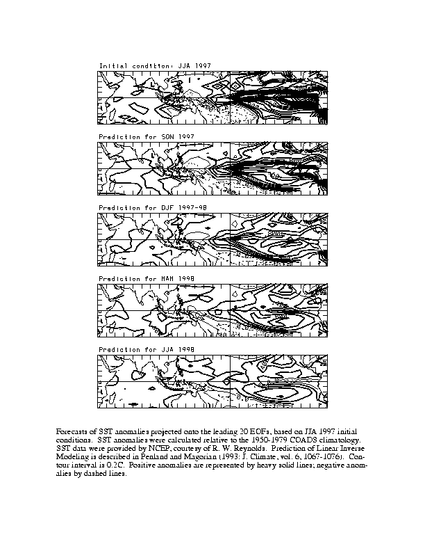
Using the methods previously described in issues of the Experimental Long-Lead Forecast Bulletin, in Penland and Magorian (1993), and in Penland and Matrosova (1997), the pattern of IndoPacific sea-surface temperature anomalies (SSTAs; Fig. 1), as well as SSTA in the Niño 3 region (6oN-6oS, 90 -150 oW; Fig. 2a), the SSTA in the Niño 4 region (6oN-6oS, 150oW-160oE; Fig. 2b), the tropical North Atlantic (Figs. 3 and 4), and the Caribbean (Figs. 3 and 5) are predicted. A prediction at lead time is made by applying a statistically-obtained Green function G() to an observed initial condition consisting of SSTAs in an appropriate domain. Although the parameters of the model are obtained statistically, the dynamical assumption of stable linearity implicit in the method (an assumption that in the case of tropical SSTs is largely corroborated by data) requires a fixed-point attractor in phase space. The technique, therefore, cannot be considered a purely statistical prediction method (Penland 1989; Penland and Sardeshmukh 1995). Data have been provided by NCEP, courtesy of R.W. Reynolds. Two sets of predictor/predictands are used, one for the IndoPacific and one for the tropical Atlantic. In both cases, three-month running means of the temperature anomalies are used, the seasonal cycle has been removed, and the data have been projected onto the 20 leading empirical orthogonal functions (EOFs).
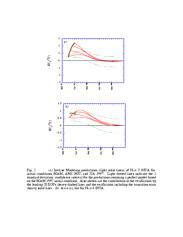
The prediction of IndoPacific SSTAs used tropical SSTAs in the region 30oN-30oS, 30oE-70oW as predic-tors. The COADS 1950-79 climatological annual cycle has been removed, and the leading 20 EOFs explain about 70% of the variance. The Niño 3 region has an RMS temperature anomaly of about 0.7oC; the inverse modeling prediction method has an RMS error of about 0.5oC at a lead time of nine months and approaches the RMS value at lead times of 18 months to two years. The predicted IndoPacific SSTA patterns based on the JJA 1997 initial condition for the following SON, DJF, MAM and JJA are shown in Fig. 1 (contour interval = 0.2oC). Figure 2a shows the predictions (light solid lines) of the Niño 3 anomaly for initial conditions MAM, AMJ, MMJ and JJA, 1997. Light dotted lines indicate the 1 standard deviation expected error for the prediction assuming a perfect model based on the MAM 1997 initial conditions. Figure 2b is the same, but for the Niño 4 region. Verifications including the truncation error (heavy solid line) and omitting the truncation error (heavy dotted line) are also shown. While nearly all the SSTA variability in Niño 3 has been contained in the leading 20 EOFs recently (the difference is indistinguishable on a black-and-while plot), we see that much of the Niño 4 SSTA allows us to be optimistic. The corresponding transition in the Niño 3 region is not so smooth, consistent with LIM's tendency to predict a premature decay of Niño 3 SSTA when initialized during the warmest phase of the ENSO cycle.
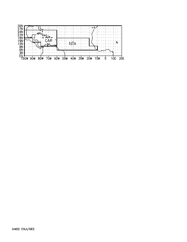
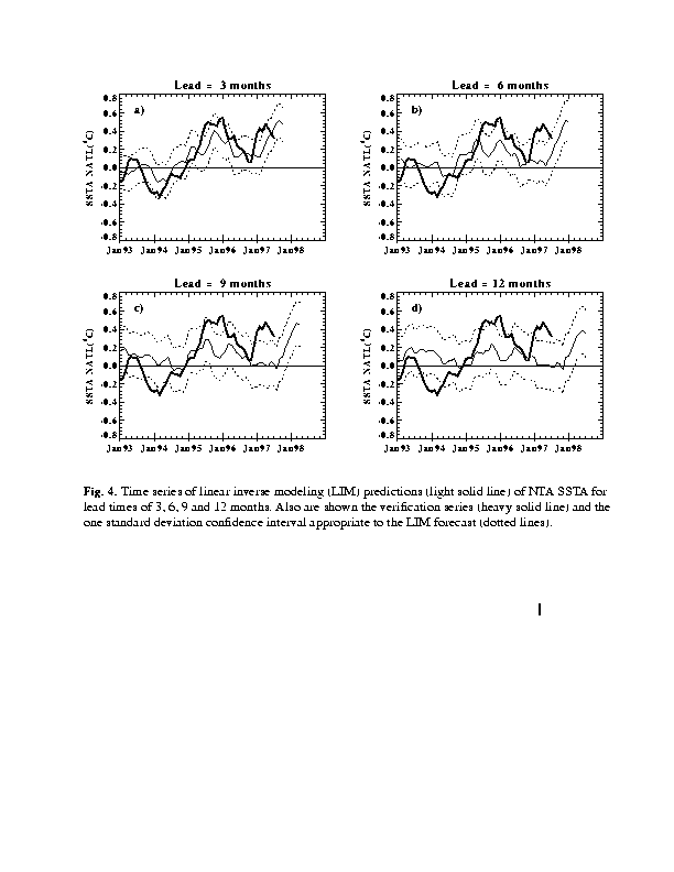
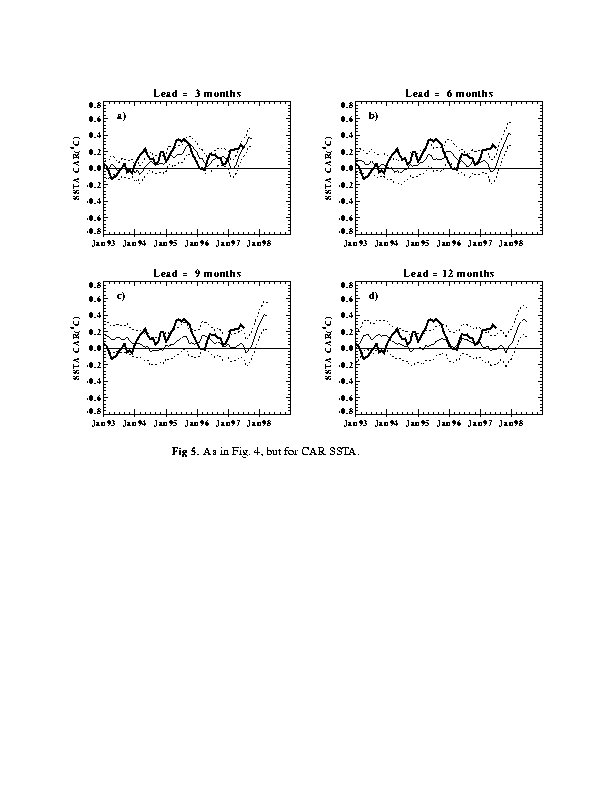
The prediction of tropical Atlantic SSTAs is confined to the north tropical Atlantic (NTA) and Caribbean (Car) sectors (Fig. 3) since persistence is a remarkably good predictor of SSTA in the equatorial and south tropical Atlantic (Penland and Matrosova 1997). The added predictability in the northern tropical Atlantic is primarily due to the effect of El Niño, so SSTAs in the global tropical strip (30oN-30oS) are used as predictors. Forecast skill is indicated in the March 1997 issue of this Bulletin. The COADS annual cycle has been removed from three-month running means of SSTs and anomalies were projected onto the leading 20 EOFs containing about 67% of the variance. The SSTA is predicted to rise in those regions, followed by an SSTA decrease after about 9 months (Figs. 4 and 5).
Penland, C., 1989: Random forcing and forecast-ing using Principal Oscillation Pattern Analysis. Mon. Wea. Rev., 117, 2165-2185.
Penland, C. and T. Magorian, 1993: Prediction of Niño 3 sea-surface temperatures using linear inverse- modeling. J. Climate, 6, 1067-1076.
Penland, C. And P.D. Sardeshmukh, 1995: The optimal growth of tropical sea surface temperature anomalies. J. Climate, 8, 1999-2024.
Penland, C. and L. Matrosova, 1997: Prediction of tropical Atlantic sea surface temperatures using Linear Inverse Modeling. J. Climate, 10, in press.
Fig. 1. Linear inverse modeling forecasts of SST anomalies, relative to the standard 1950-79 COADS climatology both for the training period (1950-84) and for these forecasts. Forecast anomalies are projected onto 20 leading EOFs, based on Jun-Jul-Aug 1997 initial conditions (top panel). Contour interval is 0.2oC. Positive anomalies are represented by heavy solid lines, negative anomalies by dashed lines. SST data have been provided by NCEP, courtesy of R.W. Reynolds. Prediction by linear inverse modeling is described in Penland and Magorian (1993: J. Climate, 1067-1076).
Fig. 2. (a): Inverse modeling predictions (light solid lines) of Niño 3 SSTA for initial conditions Mar-Apr-May, Apr-May-Jun, May-Jun-Jul and Jun-Jul-Aug 1997. Light dotted lines indicate the 1 standard deviation confidence interval for the prediction assuming a perfect model based on the Mar-Apr-May 1997 initial condition. Also shown are the contribution to the verification by the 20 leading EOFs (heavy dashed lines) and the verification including the truncation error (heavy solid lines). (b): As in (a) except for Niño 4.
Fig. 3. Map showing the North Tropical Atlantic (NTA) and Caribbean (CAR) regions, within which the average SSTA is predicted.
Fig. 4. Time series of linear inverse modeling (LIM) predictions (light solid line) of NTA SSTA for lead times of 3, 6, 9 and 12 months. Also shown are the verification series (heavy solid line) and the one standard deviation confidence interval appropriate to the LIM forecast (dotted lines).
Fig. 5. As in Fig. 2, but for CAR SSTA.