Skip Navigation Links www.nws.noaa.gov 
NOAA logo - Click to go to the NOAA home page National Weather Service   NWS logo - Click to go to the NWS home page
Climate Prediction Center

 
HOME > Expert Assessments > Climate Diagnostics Bulletin  
 

figure t17

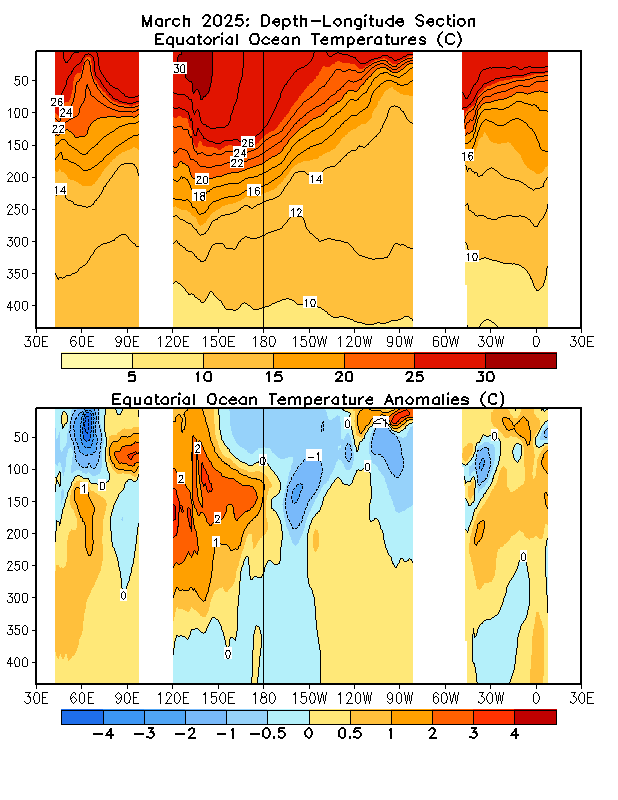
FIGURE T17. Equatorial depth-longitude section of ocean temperature (top) and ocean temperature anomalies (bottom). Contour interval is 1°C. Dashed contours in bottom panel indicate negative anomalies. Data are derived from the NCEP’s global ocean data assimilation system which assimilates oceanic observations into an oceanic GCM (Behringer and Xue, Proceedings of Eighth Symposium on Integrated Observing and Assimilation Systems for Atmospher, Oceans, and Land Surface, Seattle, Washington, 11-15 January 2004). Anomalies are departures from the 1981-2010 base period means.


NOAA/ National Weather Service
NOAA Center for Weather and Climate Prediction
Climate Prediction Center
5830 University Research Court
College Park, Maryland 20740
Page Author: Climate Prediction Center Internet Team
Page last modified: August 16, 2005
Disclaimer
Information Quality
Credits
Glossary
Privacy Policy
Freedom of Information Act (FOIA)
About Us
Career Opportunities