|
Latest Monthly Assessment -
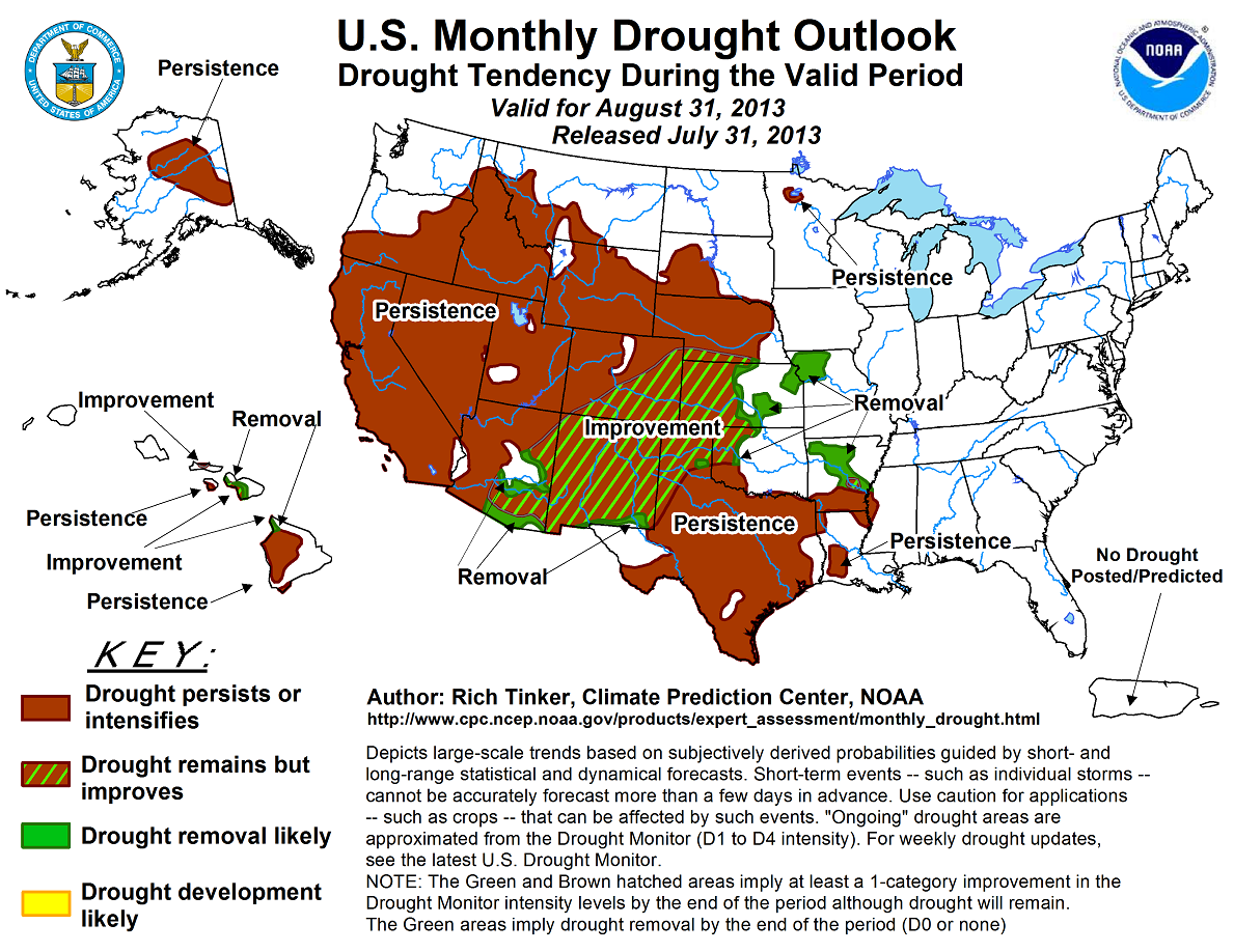
During July 2013, heavy rains fell on many of the drought areas from the central Plains southward through central Texas, and generally above-normal totals were observed in most
monsoon-affected areas from western Texas westward through Arizona and northward into the central Rockies. Below-normal precipitation dominated Iowa, northern Missouri, and
eastern Nebraska while seasonably dry weather was observed across the northern Intermountain West and along the West Coast. Drought persisted across a swath in central Alaska and
through central and southwestern Hawaii, but the remnants of Tropical Storm Flossie dropped heavy rains on some of Hawaii’s drought areas late in the month. Many locations
received over an inch of rain, with 3 to 6 inches soaking a few locations, primarily in Maui. Flossie’s remnants should bring improvement to areas receiving the heaviest
precipitation from the northern Big Island across Maui and Molokai, with persistence forecast elsewhere. August is expected to be warm across Alaska, and with no strong
indications of wetness or dryness, this should serve to keep drought intact there considering the time of year. In the contiguous 48 states, drought improvement or removal is
anticipated in typically monsoon-affected areas in the Southwest and southern Rockies as far west as central Arizona. Drought should also improve across the central Plains from
Nebraska, northeastern Colorado, and Missouri southward through central Arkansas, central Oklahoma, and the northern Texas Panhandle. where a stalled front should serve as a
focus for rainfall during at least the first half of the month. This front could also bring above-normal precipitation to the northern Intermountain West, but given expected
above-normal temperatures, the relatively dry time of year, and the climatological tendency for soil moisture to drop during August, drought should persist in southwest Montana
and central Idaho. Drought persistence is also expected in seasonably-dry areas of the West and in the northern and southern reaches of the Plains, away from the anticipated
frontal boundary.
|
|
Tools used in the monthly U.S. Drought Outlook (MDO) included the official CPC temperature and precipitation outlooks
for August 2013, various short- and medium-range forecasts and
models such as the 6-10 day and 8-14 day forecasts, the NAEFS precipitation outlooks, the soil moisture tools based
on the Constructed Analog on Soil (CAS) moisture, dynamical models (CFSv2, NMME, and IMME), the 384-hour
total precipitation forecasts from several runs of the GFS, the 7-day quantitative precipitation forecast from the NCEP Weather
Prediction Center, climatology, and initial conditions. As of July, we remain in ENSO Neutral conditions.
For the first half of August, or much of it, a front is expected to stall along lower sections of the central Plains, serving as a focus for precipitation. Several
inches are possible in areas from southernmost Nebraska and northern Missouri southward through Kansas, eastern Colorado, much of the Texas and Oklahoma Panhandles,
and the northern two-thirds of Oklahoma and Arkansas, thus drought should improve in these areas. South of this swath, substantial precipitation seems less likely
and given the climatological tendency toward soil moisture loss, persistence seems the best bet here, including southern sections of the Texas Big Bend where
monsoonal rains could be lacking early in the month at least. Farther north in the northern Plains, there is some indication that above-normal precipitation may occur
for the first half of the month, but with lesser amounts and lower likelihoods. Given the climatologically-greater tendency for soil moisture to decline in these
areas, persistence is also forecast for areas north of the swath of improvement.
Forecast confidence is high in the central Plains, moderate farther north and south away from the expected position of the frontal boundary.
In the northern Rockies and Intermountain West, drought persistence is forecast despite indicators favoring above-normal precipitation during at least the first half
of the month, and for the month as a whole in southwestern Montana and adjacent Idaho and Wyoming. Despite the potential short-term precipitation surplus, August is
climatologically dry relative to other times of the year, especially in the northern Intermountain West, and soil moisture is depleted on the order of 5% to 15% more
often than not in these areas. Furthermore, warmer than normal conditions are expected for August, so despite some indicators, climatology and other considerations
indicate that drought should persist in northern sections of the Rockies and Intermountain West.
Forecast confidence in the northern Rockies and Intermountain West is moderate.
In the southern and east-central Rockies, including the Southwest, August is one of the wetter times of the year due to the seasonal monsoon that begins to wind down
as the month progresses. Some places near the Arizona/New Mexico border typically get 20% to 25% of their annual rainfall during August. From eastern Arizona and
central Colorado to the south and east, enhanced chances for a wetter-than-normal August further points toward increased soil moisture content and drought
improvement, and this is the forecast for that area. Farther north and west, across western and northern Arizona, western Colorado, and Utah, the August 2013
indicators for monsoonal precipitation are not as robust, and across the west-central Rockies soil moisture declines as often as not climatologically despite this
being a wetter time of year. All things considered, persistence seems the best forecast in these areas.
Forecast confidence is high in New Mexico and eastern Arizona, moderate elsewhere.
Across the Far West, August is climatologically quite dry and soil moisture content almost always declines regardless of whether it is wetter or drier than normal,
so persistence is forecast.
Forecast confidence in the Far West is high.
There is no strong indication that Alaska will be significantly wetter or drier than normal, but a warmer than normal month is strongly indicated. Given the time of
year, persistence seems the best forecast.
Forecast confidence in Alaska is moderate.
Hawaii is a tough forecast. Outside of tropical systems, this is typically a dry time of year, so any improvement made would be caused by the recent heavy rains from
the remnants of Tropical Storm Flossie. Many areas received over an inch, with 3 to 6 inches falling on parts of Maui. Given how quickly the rain fell, it is unclear
how much benefit will eventually be realized, but at this juncture, the odds slightly favor some improvement in the areas that were the wettest, specifically the
northern reaches of the Big Island, Maui, and Molokai. Persistence is expected elsewhere.
Forecast confidence in Hawaii is low.
|


