|
Latest Seasonal Assessment -
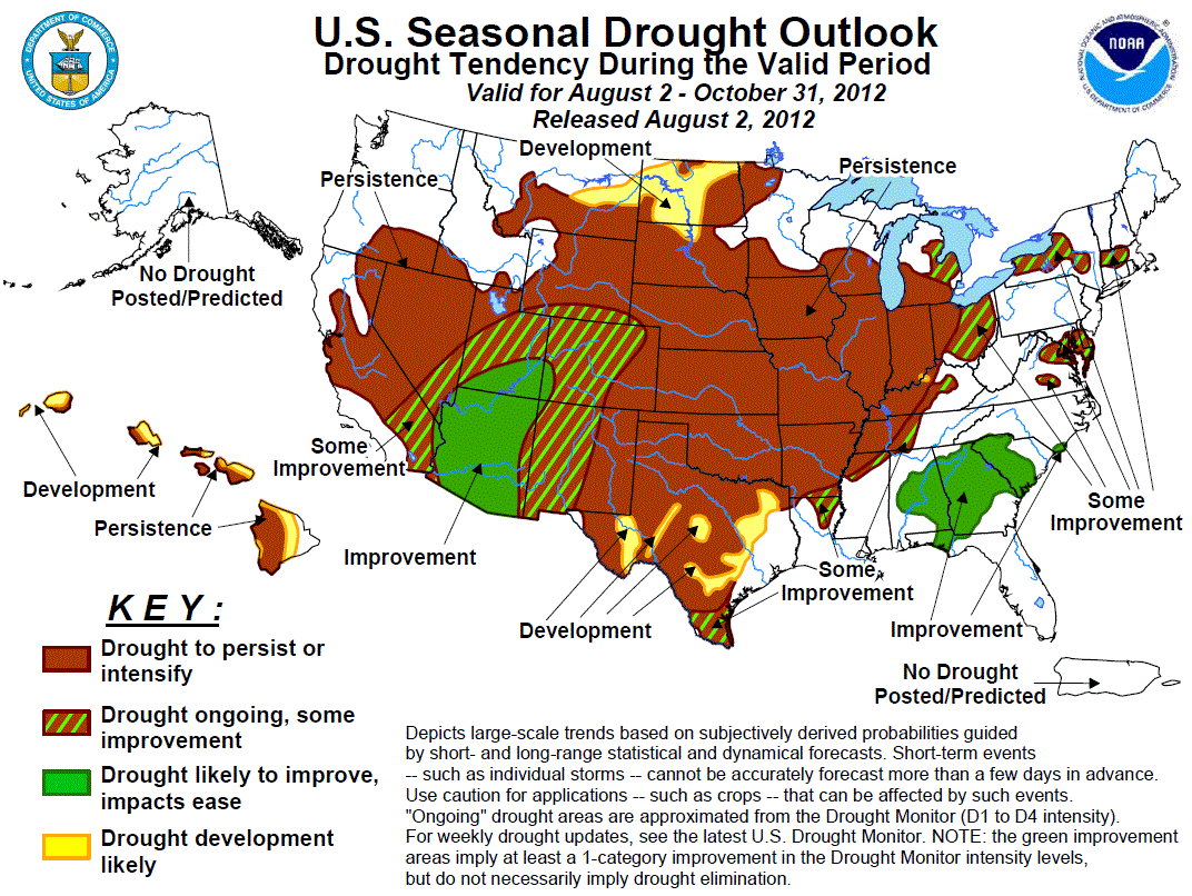
Dryness and drought, exacerbated by above-normal temperatures, have been increasing both in extent and intensity across much
of the central and northern U.S. Based upon the July 24 U.S. Drought Monitor, almost 64 percent of the contiguous U.S. was in
drought (D1-D4), the highest such value for the U.S. Drought Monitor since its inception in 2000. The last time the lower 48
States had a comparable area of drought (based upon the monthly Palmer Drought Index) was in 1956, according to NCDC. The
drought and heat arrived at a critical time for Midwestern agriculture, especially corn. The combination of heat and dryness
has severely reduced the quality and quantity of the corn and soybean crop, with 48 percent of the corn and 37 percent of the
soybeans rated as poor or very poor as of July 29 by NASS/USDA. Over half the corn was adversely rated in 8 major
corn-producing states, including 83, 79, 71, and 69 percent in Missouri, Kentucky, Illinois, and Indiana, respectively.
Similarly, the soybean crop rated poor to very poor exceeded 50 percent in Missouri, Kansas, Illinois, Indiana, and Kentucky.
Unfortunately, drought is expected to develop, persist, or intensify across these areas, and temperatures are likely to
average above normal. With dry weather expected in the northern Plains the next few weeks and most locations already abnormally
dry, D1 development was added in eastern Montana and North Dakota. Some widely-scattered relief may come in the form of cold
front passages or organized thunderstorm clusters (MCSs), but widespread relief for much of the area is not expected. In the
Southeast, recent widespread thunderstorm activity has somewhat eased drought there. The 6-10 and 8-14 day outlooks favor
above-normal rainfall, August-October is a climatologically wet period in southern Texas, and the 3-month outlook favors
increased odds for above normal precipitation along the central Gulf. Therefore, improvement to some improvement is expected
across the Deep South, from southern Texas eastward to South Carolina. In New England and the mid-Atlantic, recent scattered
thunderstorms have provided relief to some locations from abnormal dryness and moderate drought, but where the rains missed,
D0 and D1 have persisted or slightly expanded. With wet weather expected during the next few weeks, some improvement is
expected from the eastern Ohio Valley into the Northeast. Across the Southwest, the odds favor an active (wet) southwest
monsoon in both the 1- and 3-month precipitation outlooks. As a result, improvement is anticipated across much of Arizona,
southern Utah, and southwestern Colorado as the summer monsoon continues, with some improvement in other parts of the region.
Drought persistence is the best bet across the remaining portions of the Western U.S. since late summer and early fall are
typically dry. In Hawaii, subnormal seasonal rainfall is expected which should maintain drought on the leeward (west) sides
while expanding it into the windward (east) sides. Lastly, an El Niño Watch continues, with the forecaster consensus
reflecting increased chances of an El Niño beginning in July-September.
|
|
Tools used in the U.S. Drought Outlook (USDO) included the official CPC temperature and precipitation outlooks
for August 2012 and the long lead forecast for
August through October 2012, various medium- and short-range forecasts and models such as
the 6-10 day and 8-14 day forecasts, the most recent 384-hour GFS total precipitation amounts, the
soil moisture tools based on the Constructed Analog on Soil (CAS) moisture, the Climate
Forecast System (CFS, versions 1 and 2), the four-month Palmer drought termination and amelioration probabilities, climatology,
and initial conditions.
After receiving heavy to excessive rains in May from Tropical Storm Beryl and from Tropical Storm Debby in June, drought
was alleviated from most of Florida and southeastern Georgia by late June. But subnormal rainfall returned to most of
Florida, eastern Georgia, and parts of Alabama during July. In the remainder of the Southeast, however, July was
generally wet with temperatures close to normal, and some drought improvement has occurred. The extended-range forecasts
(6-10 day and 8-14 day) and 384-hour GFS anticipate elevated odds of above normal median rainfall in most of the
Southeast. Though CPC’s updated August outlook calls for Equal Chances (EC) of below-, near-, and above-median
precipitation across much of the Southeast (except for below normal odds for northern Arkansas and western Tennessee),
the seasonal outlook for August-October, as well as the CFSv2 model, favors wetter-than-median conditions over the
central Gulf Coast region. In addition, the odds for at least some improvement are elevated closer to the coast which is
often affected by sea-breeze induced thunderstorms and the “wild card factor” - tropical systems – where ASO are usually
the peak months. In addition, it is difficult to sustain a drought in an area where the normal annual precipitation is
40 to 50 inches (e.g. Georgia, Alabama, and Tennessee) and evenly distributed per month. Monthly and seasonal temperature
outlooks also favor above-normal temperatures mainly in northern regions, with decreasing odds as one heads south and
east to the Gulf and Atlantic. Therefore, drought should persist or show some improvement in the north, and show
improvement in the south. Note that improvement in the south does not mean elimination of drought as this area has
accumulated long-term deficits that would be difficult to eradicate by the end of October.
Forecast confidence for the Southeast (including lower Mississippi and Tennessee Valleys) is moderate.
During the past 2 weeks, moderate to heavy rains (2-5 inches) in the Northeast and mid-Atlantic and less oppressive
temperatures have somewhat eased abnormal dryness and drought in the Northeast. Unfortunately, some areas (e.g. Delmarva
Peninsula, central and southern Virginia, and Maine) saw no improvement or deteriorated as significant precipitation
bypassed them. Although the short and medium-term models predict some moderate to heavy rain in the mid-Atlantic and New
England (although above normal temperatures), there are no clear indications in the August and ASO precipitation outlooks
for dry or wet odds (equal chances). But since most of the D0 and D1 have recently developed in the Northeast and
mid-Atlantic (short-term), a brief period of wet weather could alleviate the accumulated deficiencies (2 to 4 inches at
30- and 60-days) - hence the Some Improvement label. Farther west, recent heavy rains (3 to 7 inches), expected
short-term wetness, and an updated August precipitation outlook of EC (instead of odds for dryness) indicates some
possible improvement of drought in the eastern Ohio Valley and western New England instead of development.
Forecast confidence for the Northeast and Mid-Atlantic regions is moderate.
The critical growing month of July became the third consecutive month with unseasonable warmth and dryness across much of
the Nation’s midsection, expanding and intensifying the Midwestern drought while adversely impacting agriculture. July
deficits ranged between 3 to 6 inches from the central Great Plains to the eastern Ohio Valley. Temperatures averaged at
least 6 degrees F above normal across much of the Midwest and central Plains, with triple-digit highs common during the
month. The 8-14 day, updated August, and ASO Outlooks call for enhanced chances of below-median rainfall and
above-normal temperatures for most of the region. An exception is the upper Midwest which may see decent rains in the
short-term. Unfortunately, the self-perpetuation of regional drought conditions, with very dry soils and very limited
evapotranspiration, tends to inhibit widespread development of or weaken existing thunderstorm complexes. It would
require a dramatic shift in the weather pattern to provide significant relief to this drought, and most tools and models
do not forecast this. Accordingly, drought is maintained across the Midwest and expanded northwest to encompass North
Dakota and eastern Montana. In the eastern Ohio Valley (see Northeast and mid-Atlantic discussion), some improvement is
possible.
Forecast confidence for the Midwest (including Ohio Valley) is moderate.
Similar to the Midwest, July brought subnormal rainfall and above normal temperatures to most of the Plains. Only
portions of southern Texas, southeastern New Mexico, northeastern Colorado, eastern Montana, and parts of the Dakotas
reported surplus July precipitation. Monthly temperatures averaged 4 to 8 degrees F above normal. During the last 90
days, most of the central Plains accumulated deficits of 4 to 8 inches, with 8 to 12 inch shortages in eastern Kansas
and northeastern Oklahoma. For the first 5-days of this outlook, an upper-air ridge will continue to steer moisture and
storms around its periphery, resulting in little to no rainfall for the southern Plains. Fortunately, some rain is
expected from North Dakota southward into Nebraska as southwestern monsoonal moisture interacts with a cold front.
Unfortunately, the CPC 6-10 and 8-14 day precipitation forecasts maintain unfavorable odds for rainfall in the southern
half of the Great Plains. CPCs updated 30-day outlook favors enhanced odds for subnormal precipitation in the central
Great Plains, with equal chances elsewhere. CPCs 90-day precipitation outlook has no odds either way (equal chances).
Climatologically, the northern and southern Plains reach their normal wet time of the year during the late spring and
early summer, so by the fall their precipitation is usually waning. Unfortunately, all indicators (short and medium-term,
August, and August-October) favor above normal temperatures. With much of the Plains already in drought and getting
worse, above normal temperatures expected into the fall, and a dry short-term and 30-day forecast, the drought should
persist, with some possible development in the northern Plains.
Forecast confidence for the Plains is moderate.
In the Southwest and southern High Plains, the June-September period is critical for producing monsoonal rains. In parts
of Arizona, New Mexico, western Texas, and eastern Colorado, a large majority of its normal annual precipitation occurs
during these 4 months. Therefore, a forecast for above normal monthly and seasonal precipitation during this period may
bring drought-relieving rains. Since July 1, the southwest monsoon has been generous across much of the Southwest, with
most areas also reporting surpluses out to 30-days, and some portions (most of Arizona and southeast California) out to
60 and 90 days. CPCs precipitation outlook suite for the extended-, monthly-, and seasonal ranges (including the
seasonal CFSv2 forecast) all favor near- to above-median rainfall across this region. With most tools and models in
agreement, improvement is forecast for Arizona, southern Utah, and southwestern Colorado, with some improvement for the
remainder of the Southwest.
Forecast confidence for the Southwest is moderate to high.
Widespread moderate to severe drought covers the rest of the western U.S. except for the Northwest. While the
southwestern monsoon can bring moisture throughout the Four Corners States, southeastern California, and southern Nevada,
the summer is climatologically dry across the Great Basin, the rest of California, and the Northwest. In addition,
persistent wet and cool weather in the Northwest during the past several months has accumulated surpluses at 2 to 6
months out, making it difficult for drought to develop anytime soon. CPCs extended range forecasts show near normal
probabilities at 6-10 days, and tilt toward subnormal precipitation at 8-14 days. The monthly and seasonal outlooks favor
slightly enhanced odds of below-median precipitation over the Northwest, and equal chances in the Great Basin and
northern Rockies. Therefore the seasonal drought forecast calls for the existing drought to continue without any areas of
improvement or new development.
Forecast confidence for the West is moderate to high.
The summer months are climatologically dry in Hawaii, but as the fall commences rainfall normally increases. The latest
Hawaiian monthly and seasonal outlooks (from dynamical models) slightly tilt toward subnormal rainfall. Therefore,
drought is expected to persist in existing areas (mainly leeward sides), and slowly spread eastward into the windward
sides, especially later in the period. The exception is Kauai where D1 covers the eastern portion, with drought
development expected to push westward.
Forecast confidence for Hawaii is moderate to high.
|


