|
Tools used in the U.S. Drought Outlook (USDO) included the official CPC temperature and precipitation outlooks
for June 2012 and the long lead forecast for
June through August 2012,
various medium- and short-range forecasts and models such as the 6-10 day and
8-14 day forecasts, the most recent 384-hour GFS total precipitation amounts, the soil moisture tools
based on the Constructed Analog on Soil (CAS) moisture, the Climate Forecast System (CFS, versions 1 and 2), the
four-month Palmer drought termination and amelioration probabilities, climatology, and initial conditions.
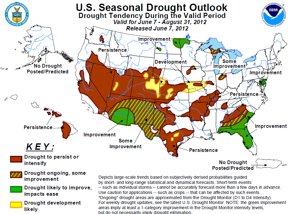
Tropical Storm Beryl brought locally torrential rainfall to much of Florida and the southeastern Coastal Plain,
with Wellborn Florida receiving 15 inches of rain from the storm. The storm brought much needed rainfall to
these regions, extinguishing 80 percent of the 25 active wildfires in northern Florida, but also caused flash
flooding and minor damage. Short term forecasts indicate 1-3 inches of new rainfall across all of Florida north
of Lake Okeechobee including the Panhandle, with heavier amounts possible across southern Georgia. The wet
pattern is expected to continue into the week 2 period. Seabreeze driven thunderstorm activity during the
summer months contributes a significant portion of the annual rainfall across the coastal Southeast, and CPC's
monthly and seasonal outlooks maintain equal chances for near, below or above median rainfall. Therefore,
continued drought reduction is expected across Florida and the coastal Southeast due to the wet short term
forecasts and rainy climatology.
Forecast confidence for Florida and coastal areas of the Southeast is moderate to high.
Extreme to exceptional drought extends across parts of eastern Alabama, central Georgia, and western South
Carolina. Little additional rainfall fell across these regions during the previous two weeks, despite the
passage of Tropical Storm Beryl to the east. Much of this drought is deeply entrenched, with 6 month rainfall
deficits of 12-16 inches in central Georgia. While short and medium range guidance indicates the possibility of
heavy rainfall along the Gulf Coast, the expected precipitation decreases substantially in Piedmont locales.
CPC monthly and seasonal outlooks indicate equal chances for near, below or above median rainfall across the
Southeast. Based on these outlooks, it is unlikely that summer convective activity will significantly reduce
the long term rainfall deficits across north-central Georgia, middle Tennessee, and the upstate of South
Carolina. Therefore, persistence is forecast across the interior Southeast.
Forecast confidence for the interior Southeast is moderate.
Widespread heavy thunderstorms associated with cold fronts overspread the mid-Atlantic and Northeastern states
during late May and early June, bringing continued improvement to the remaining areas of moderate drought.
Unsettled weather and below average temperatures are expected in the short term, with dry, warmer weather
overspreading the East by the end of the week. Medium range forecasts, including the CPC 8-14 day outlook and
the GFS indicate a return to rainy weather during week 2. CPC's monthly and seasonal outlooks maintain equal
chances for near, below or above median rainfall. Based on these forecasts, it is likely that summer convection
will bring further improvements to the relatively shallow drought areas of the mid-Atlantic.
Forecast confidence for the mid-Atlantic and Northeast is moderate.
Although much of the central Corn Belt is suffering from short-term dryness, development is not forecast for
Iowa and most of Illinois since the CPC monthly and seasonal outlooks indicate equal chances for below, near, or
above median precipitation. Some improvement is forecast for the small areas of moderate drought in Iowa and
northern Indiana since summer climatology tends to be relatively wet for these areas.
Forecast confidence for the central Corn Belt is low.
Abnormal dryness and drought have expanded rapidly across the lower and middle Mississippi Valley due to
inadequate late spring rainfall and above normal temperatures. Persistence is expected across the ongoing
drought areas across the middle Mississippi Valley, lower Ohio Valley, and Arkansas since a wet signal is not
apparent among the precipitation tools and above normal temperatures are favored in the CPC monthly and seasonal
outlooks. Development is forecast across northern Missouri where the largest 30-day precipitation deficits (more
than 4 inches) exist.
Forecast confidence for the lower/middle Mississippi Valley and lower Ohio Valley is low.
Moderate drought has expanded across much of Kansas, Oklahoma, and Texas due to a lack rainfall during a
typically wet time of year. Since none of the precipitation tools indicate a wet signal and the CPC
monthly/seasonal outlooks indicate enhanced odds for above normal temperatures, persistence is forecast for the
ongoing drought areas. Heavy rainfall that is expected at the beginning of the outlook period is expected to
occur in the drought-free areas of Oklahoma and northeast Texas.
Forecast confidence for the central/southern Plains is low.
Persistence is forecast for the ongoing drought areas of Colorado, while development likely for eastern Colorado
where abnormal dryness is depicted on the U.S. Drought Monitor. These forecasts are based on very dry initial
conditions, CPC’s June outlook favoring below median precipitation, and enhanced odds for above normal
temperatures in the CPC June/June-August outlooks.
Forecast confidence for Colorado is moderate.
Severe to extreme drought is ongoing across southern Arizona and New Mexico. The Southwestern Monsoon onset
typically occurs in July, with peak rainfall occurring during August. Monsoon thunderstorms have the potential
to bring local drought relief, but there is quite a bit of uncertainty in the monsoon's intensity and extent
forecast. A lack of snow cover in the southern Rockies may promote an early development of the Southwestern
heat low, which could bring monsoon rains as early as June, but some forecast tools indicate a below average
monsoon signal, particularly in eastern locations. Even given an average monsoon, annual rainfall deficits are
large across southern New Mexico and the Texas panhandle. Therefore, some improvement is forecast across the
monsoon region of the Southwest, with a small area of improvement in southeastern Arizona and southwestern New
Mexico.
Forecast confidence for the Southwest is low.
Widespread moderate to severe drought covers much of the remainder of the Southwestern U.S., and a small area of
moderate drought has developed in central Washington. While the Southwestern Monsoon can bring moisture
throughout the Four Corners States, the summer is climatologically dry across the Great Basin, California, and
the Northwest. The CPC 6-10 and 8-14 day outlooks both favor abnormal dryness across the Southwest, while the
monthly and seasonal outlooks indicate enhanced odds for below median precipitation in the Northwest. Based on
these forecasts, persistence is expected across the drought areas of the western U.S.
Forecast confidence for the remainder of the West is high.
Improvement or some improvement is forecast for the upper Mississippi Valley due to expected rainfall early in
the period, enhanced odds for above median precipitation in the 6-10/8-14 day outlooks, and a wet climatology.
Forecast confidence for the upper Mississippi Valley is moderate.
The summer months are climatologically dry in Hawaii. Therefore, little improvement in existing drought areas
is expected through August.
Forecast confidence for Hawaii is high.
|


